Hays, North Carolina

Last updated

Hays, North Carolina
CDP
NCMap-doton-Hays.PNG
Location of Hays, North Carolina
Coordinates: 36°15′17″N81°07′50″W / 36.25472°N 81.13056°W / 36.25472; -81.13056
Country United States
State North Carolina
County Wilkes
Area
[1]
  Total6.16 sq mi (15.95 km2)
  Land6.16 sq mi (15.95 km2)
  Water0.00 sq mi (0.00 km2)
Elevation
[2]
1,339 ft (408 m)
Population
 (2020)
  Total1,595
  Density259.01/sq mi (100.00/km2)
Time zone UTC-5 (Eastern (EST))
  Summer (DST) UTC-4 (EDT)
ZIP code
28635
Area code 336
FIPS code 37-30340 [3]
GNIS feature ID2402572 [2]

Hays is a census-designated place (CDP) in Wilkes County, North Carolina, United States. The population was 1,595 at the 2020 census. North Wilkes High School, one of Wilkes County's four public high schools, is located in Hays.

Contents

Geography

According to the United States Census Bureau, the CDP has a total area of 6.1 square miles (16 km2), all land.

Demographics

Historical population
CensusPop.Note
2020 1,595
U.S. Decennial Census [4]

As of the census [3] of 2000, there were 1,731 people, 686 households, and 526 families residing in the CDP. The population density was 283.1 inhabitants per square mile (109.3/km2). There were 729 housing units at an average density of 119.2 per square mile (46.0/km2). The racial makeup of the CDP was 98.21% White, 0.52% African American, 0.23% Asian, 0.75% from other races, and 0.29% from two or more races. Hispanic or Latino of any race were 1.04% of the population.

There were 686 households, out of which 34.3% had children under the age of 18 living with them, 62.8% were married couples living together, 9.3% had a female householder with no husband present, and 23.2% were non-families. 20.3% of all households were made up of individuals, and 8.0% had someone living alone who was 65 years of age or older. The average household size was 2.51 and the average family size was 2.88.

In the CDP, the population was spread out, with 23.2% under the age of 18, 8.1% from 18 to 24, 32.8% from 25 to 44, 24.6% from 45 to 64, and 11.4% who were 65 years of age or older. The median age was 37 years. For every 100 females, there were 96.5 males. For every 100 females age 18 and over, there were 96.5 males.

The median income for a household in the CDP was $37,642, and the median income for a family was $40,144. Males had a median income of $27,601 versus $21,520 for females. The per capita income for the CDP was $16,869. About 12.6% of families and 17.6% of the population were below the poverty line, including 29.2% of those under age 18 and 11.5% of those age 65 or over.

Related Research Articles

<span class="mw-page-title-main">Pelican Bay, Florida</span> Census-designated place in Florida

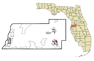
Pelican Bay is a census-designated place (CDP) in Collier County, Florida, United States. The population was 6,346 at the 2010 census. It is part of the Naples–Marco Island Metropolitan Statistical Area.

<span class="mw-page-title-main">High Point, Hernando County, Florida</span> Census-designated place in Florida, United States

High Point is an unincorporated area and census-designated place (CDP) in Hernando County, Florida, United States. The population was 3,686 at the 2010 census.

<span class="mw-page-title-main">Zephyrhills North, Florida</span> CDP in Florida, United States

Zephyrhills North is a census-designated place (CDP) in Pasco County, Florida, United States. The population was 2,544 at the 2000 census.

<span class="mw-page-title-main">Cricket, North Carolina</span> CDP in North Carolina, United States

Cricket is a census-designated place (CDP) located between Wilkesboro and North Wilkesboro in Wilkes County, North Carolina, United States. The population was 2,053 at the 2000 census.

<span class="mw-page-title-main">Fairplains, North Carolina</span> CDP in North Carolina, United States

Fairplains is a census-designated place (CDP) in Wilkes County, North Carolina, United States. The population was 2,051 at the 2000 census. The community was named "fairplains" because it was located at the geographic point where the foothills of the Blue Ridge Mountains begin to level off to the gently rolling Piedmont region of central North Carolina.

<span class="mw-page-title-main">Millers Creek, North Carolina</span> CDP in North Carolina, United States

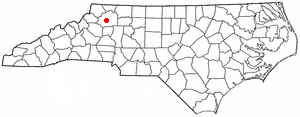
Millers Creek is a census-designated place (CDP) in Wilkes County, North Carolina, United States. The population was 2,112 at the 2010 census. West Wilkes High School, one of the four public high schools in Wilkes County, is located in Millers Creek.

<span class="mw-page-title-main">Moravian Falls, North Carolina</span> CDP in North Carolina, United States

Moravian Falls is a census-designated place (CDP) in Wilkes County, North Carolina, United States. The population was 1,802 as of the 2020 census.

<span class="mw-page-title-main">Mulberry, Wilkes County, North Carolina</span> CDP in North Carolina, Wilkes

Mulberry is a census-designated place (CDP) in Wilkes County, North Carolina, United States. The population was 2,332 at the 2010 U.S. Census. The community was given its name by the first European pioneers to settle the area in the 1750s. These settlers called the region "Mulberry Fields", after the many mulberry trees in the area. Mulberry Creek, one of the largest streams in Wilkes County, takes its name from the community of Mulberry, and flows through the area.

<span class="mw-page-title-main">Pleasant Hill, Wilkes County, North Carolina</span> CDP in North Carolina, United States

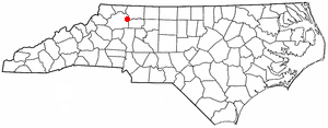
Pleasant Hill is a census-designated place (CDP) in Wilkes County, North Carolina, United States. The population was 1,109 at the 2000 census.

<span class="mw-page-title-main">Gloverville, South Carolina</span> Census-designated place in South Carolina, United States of America

Gloverville is a census-designated place (CDP) in Aiken County, South Carolina, United States. The population was 2,831 at the 2010 census. It is part of the Augusta, Georgia metropolitan area. Gloverville is located in historic Horse Creek Valley.

<span class="mw-page-title-main">Socastee, South Carolina</span> CDP in South Carolina, United States

Socastee is a census-designated place (CDP) in Horry County, South Carolina, United States. The population was 19,952 at the 2010 census.

Seven Oaks is a census-designated place (CDP) in Lexington County, South Carolina, United States, 8 miles (13 km) northwest of downtown Columbia, the state capital. The population of the CDP was 15,144 at the 2010 census. It is part of the Columbia Metropolitan Statistical Area.

<span class="mw-page-title-main">St. Andrews, South Carolina</span> Census-designated place in South Carolina, United States

St. Andrews is a census-designated place (CDP) in Richland County, South Carolina, United States. The population was 20,493 at the 2010 census. It is part of the Columbia, South Carolina Metropolitan Statistical Area.

<span class="mw-page-title-main">Mayo, South Carolina</span> CDP in South Carolina, United States

Mayo is a census-designated place (CDP) in Spartanburg County, South Carolina, United States. The population was 1,592 at the 2010 census.

Southern Shops is a census-designated place (CDP) in Spartanburg County, South Carolina, United States. The population was 3,767 at the 2010 census.

<span class="mw-page-title-main">India Hook, South Carolina</span> CDP in South Carolina, United States

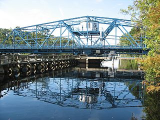
India Hook is a census-designated place (CDP) in York County, South Carolina, United States. The majority of India Hook is annexed into the city of Rock Hill, but as of 2010 India Hook is still considered to be a CDP. It is one of the three communities located on Lake Wylie.

<span class="mw-page-title-main">Jolivue, Virginia</span> Census-designated place in Virginia, United States

Jolivue is a census-designated place (CDP) in Augusta County, Virginia, United States. The population was 1,129 at the 2010 census. It is part of the Staunton–Waynesboro Micropolitan Statistical Area.

<span class="mw-page-title-main">West Side Highway, Washington</span> Former CDP in Washington, United States

West Side Highway was a census-designated place (CDP) in Cowlitz County, Washington, named after a state highway running north–south between Longview and Castle Rock. As of the 2010 census, the CDP population was 5,517. Prior to the 2020 census, the CDP was split into two new CDPs, Beacon Hill and Lexington.

<span class="mw-page-title-main">Weallup Lake, Washington</span> Former CDP in Washington, United States

Weallup Lake is a former census-designated place (CDP) in Snohomish County, Washington, United States. The population was 882 at the 2000 census. The CDP was discontinued at the 2010 census.

<span class="mw-page-title-main">Milo (CDP), Maine</span> CDP in Maine, United States

Milo is a census-designated place (CDP) in the town of Milo in Piscataquis County, Maine, United States. The population was 1,898 at the 2000 census.

References

  1. "ArcGIS REST Services Directory". United States Census Bureau. Retrieved September 20, 2022.
  2. 1 2 U.S. Geological Survey Geographic Names Information System: Hays, North Carolina
  3. 1 2 "U.S. Census website". United States Census Bureau . Retrieved January 31, 2008.
  4. "Census of Population and Housing". Census.gov. Retrieved June 4, 2016.