Sumter County is a county located in the U.S. state of South Carolina. As of the 2010 census, the population was 107,456. In a 2018 census estimate, the population was 106,512. Its county seat is Sumter.
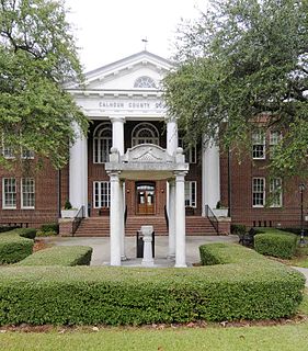
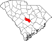
Calhoun County is a county in the U.S. state of South Carolina. As of the 2010 census, its population was 15,175, making it the third-least populous county in the state. Its county seat is St. Matthews.

Calhoun County is a county located in the U.S. state of Mississippi. As of the 2010 census, the population was 14,962. Its county seat is Pittsboro. The county is named after John C. Calhoun, the U.S. Vice President and U.S. Senator from South Carolina.

Calhoun Falls is a town in Abbeville County, South Carolina, United States. The population was 2,004 at the 2010 census.

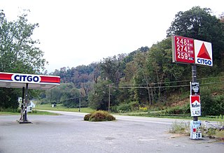
Cameron is a town in Calhoun County, South Carolina, United States. The population was 424 at the 2010 census. It is part of the Columbia, South Carolina Metropolitan Statistical Area.
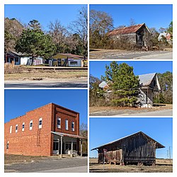
St. Matthews is a town in Calhoun County, South Carolina, United States. The population was 2,021 at the 2010 census, a decline from 2,107 in 2000. It is the county seat of Calhoun County.
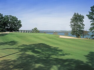
Santee is a town in Orangeburg County along the Santee River Valley in central South Carolina, United States. It has become a resort town of note located centrally north-south along the Atlantic Seaboard of South Carolina. The region has been rural, with a primarily agricultural economy typical of Orangeburg County, but is now known primarily for its several golf courses in proximity to Lake Marion, Santee State Park and other Lake Marion attractions. Interstate 95 connects its attractions easily with tourists traveling by automobile. I-95 crosses a narrow arm of the lake into the town lands, along a causeway. Lake Marion is a man-made hydroelectric reservoir, which at 110,000 acres is one of the fifty largest lakes in the country.

Clemson is a city in Pickens and Anderson counties in the U.S. state of South Carolina. Clemson is home to Clemson University; in 2015, the Princeton Review cited the town of Clemson as ranking #1 in the United States for "town-and-gown" relations with its resident university. The population of the city was 13,905 at the 2010 census.
Vanderpool is a small unincorporated community in Bandera County in the U.S. state of Texas, in the Texas Hill Country, which is part of the Edwards Plateau. It lies 30 miles (48 km) west of Bandera. Hunting, ranching and tourism are prime contributors to the regional economy. Vanderpool had a population of 22 in 1990. It is considered part of the San Antonio Metropolitan Statistical Area. The area zip code is 78885. The town is named after the first postmaster, L.B. Vanderpool.

Orangeburg–Calhoun Technical College (OCtech) is a Public community college in Orangeburg, South Carolina. It is part of the South Carolina Technical College System and serves Orangeburg and Calhoun counties.

Area codes 803 and 839 are telephone area codes in the North American Numbering Plan (NANP) for the central part of the U.S. State of South Carolina. The numbering plan area (NPA) is anchored by the city of Columbia, the state capital. It also includes most of the South Carolina portions of the Charlotte, North Carolina and Augusta, Georgia metropolitan areas. 839, an all-service overlay, was approved by the South Carolina Public Service Commission in 2019.

WHXT is an urban contemporary radio station licensed to Orangeburg, South Carolina and serves the Columbia, South Carolina market. The Alpha Media outlet is licensed by the Federal Communications Commission (FCC) to broadcast at 103.9 MHz with an effective radiated power (ERP) of 9.2 kW. The station goes by the name Hot 103.9 and its current slogan is "Columbia's #1 Choice for Blazin' Hip-Hop and R&B." Its studios are on Pineview Road in Columbia, while the transmitter tower is located west of St. Matthews, South Carolina, southeast of Columbia.
Mouth of Wilson is an unincorporated community, in Grayson County in the U.S. state of Virginia, just north of the North Carolina state line. The community lies in the Blue Ridge Highlands section of the Blue Ridge Mountains which are part of what is considered the 'Middle Appalachian Mountains' on the western banks of the New River, where the Big Wilson Creek empties its waters. The main road through the area is U.S. Route 58; other major roads include Virginia Route 16 and Virginia Route 93.
Whitetop is an unincorporated community in Grayson County, Virginia, United States. It is the southern terminus of the Virginia Creeper Trail. Whitetop is named for nearby Whitetop Mountain, the second-tallest independent mountain in the State of Virginia, behind Mount Rogers. The town is about four miles northeast of the North Carolina–Tennessee–Virginia Corners.
Sandy Run is an unincorporated community in Calhoun County, South Carolina, United States. Its elevation is 154 feet (47 m). Sandy Run is best known for hosting the United States Marine Corps semi-annual Mud Run. Sandy Run is named after a local stream, Sandy Run, which flows through Sandy Run and neighboring communities, Gaston and Swansea which flows into the Congaree River. Those who live in Sandy Run have a Gaston or Swansea address.
Sumter High School is a co-educational four-year public high school serving grades 9 through 12 in Sumter School District located in the south side of Sumter, South Carolina, United States. With an enrollment of approximately 2,300 students, Sumter High is the second-largest high school in the Midlands of South Carolina and the fifth largest in the state of South Carolina. In 2004 Sumter High School was designated The Model School for SC and one of thirty model schools nationwide by a national organization funded by the Bill and Melinda Gates Foundation.

The Regional Medical Center of Orangeburg & Calhoun Counties is a 286-bed non-profit hospital in Orangeburg, South Carolina. It is owned and operated jointly by the counties of Orangeburg and Calhoun, governed by a 17-member board representing both counties. It is the only hospital for the two counties.
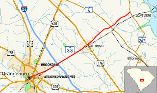
South Carolina Highway 33 (SC 33) is a 19.360-mile-long (31.157 km) state highway in the U.S. state of South Carolina. The highway connects Orangeburg with the Lone Star area, via Cameron.
South Carolina Highway 267 (SC 267) is a 23.200-mile-long (37.337 km) state highway in the U.S. state of South Carolina. The highway connects the Santee area with rural areas of Orangeburg and Calhoun counties, via Elloree.

Turnersburg Township is a nonfunctioning administrative division in northeastern Iredell County, North Carolina, United States. Turnersburg township was established in 1868. The only major town in Turnersburg township is Harmony, which is also partially within Eagle Mills township.