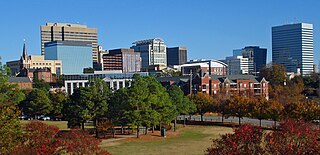
Columbia is the capital city of the U.S. state of South Carolina. With a population of 136,632 at the 2020 census, it is the second-most populous city in South Carolina. The city serves as the county seat of Richland County, and a portion of the city extends into neighboring Lexington County. It is the center of the Columbia, SC Metropolitan Statistical Area, which had an estimated population of 858,302 in 2023, and is the 70th-most populous metropolitan statistical area in the United States. The name Columbia is a poetic term used for the United States, derived from the name of Christopher Columbus, who explored for the Spanish Crown. Columbia is often abbreviated as Cola, leading to its nickname as "Soda City".

Lexington is the county seat of Davidson County, North Carolina, United States. As of the 2020 census, the town had a population of 19,632. It is located in central North Carolina, 20 miles (32 km) south of Winston-Salem. Major highways include I-85, I-85B, U.S. Route 29, U.S. Route 70, U.S. Route 52 / I-285 and U.S. Route 64. Lexington is part of the Piedmont Triad region of the state.

Cayce is a city in the U.S. state of South Carolina, along the Congaree River. The population was 12,528 at the 2010 census and rose to 13,789 in the 2020 United States Census, and it is the third-most populated municipality in Lexington County. The city is primarily in Lexington County, with additional, predominantly rural land to the east in Richland County. Cayce is part of the Columbia Metropolitan Statistical Area and is within South Carolina's Midlands region.

Lexington is the most populous town in and the county seat of Lexington County, South Carolina, United States. It is a suburb of the state capital, Columbia. The population was 23,568 at the 2020 Census, and it is the second-most populous municipality in the greater Columbia area. The 2022 estimated population is 24,626. According to the Central Midlands Council of Governments, the greater Lexington area had an estimated population of 111,549 in 2020 and is considered the fastest-growing area in the Midlands.

West Columbia, formerly Brookland, is a city and commuter town in the suburban eastern sections of Lexington County, South Carolina, United States. According to the 2010 census, the population was 14,988, and the 2019 population estimate was 17,998. West Columbia is bordered to the east by Columbia, the state capital, across the Congaree River. It is near Columbia's city center or downtown district as well as the South Carolina State House and the Congaree Vista, known locally as "the Vista". The city is bordered to the south by its sister suburb, Cayce. A small portion of the city borders the town of Lexington to the east. West Columbia is part of the greater Columbia, SC metropolitan statistical area.

Batesburg-Leesville is a town located in Lexington and Saluda counties, South Carolina, United States. The town's population was 5,362 as of the 2010 census and an estimated 5,415 in 2019.

The High Hills of Santee, sometimes known as the High Hills of the Santee, is a long, narrow hilly region in the western part of Sumter County, South Carolina. It has been called "one of the state's most famous areas". The High Hills of Santee region lies north of the Santee River and east of the Wateree River, one of the two rivers that join to form the Santee. It extends north almost to the Kershaw county line and northeasterly to include the former summer resort town of Bradford Springs. Since 1902 the town has been included in Lee County.

This is a list of the National Register of Historic Places listings in Lexington County, South Carolina.

The Greyhound Bus Depot is a former Greyhound Lines intercity bus station in Columbia, South Carolina. It is at 1220 Blanding Street in downtown Columbia. The depot was named to the National Register of Historic Places on December 28, 1989. After the bus terminal was closed, the building became a bank. Currently, it is a physician's office.

The Exeter Waterfront Commercial Historic District encompasses the historic commercial and residential waterfront areas of Exeter, New Hampshire. The district extends along the north side of Water Street, roughly from Main Street to Front Street, and then along both sides of Water and High streets to the latter's junction with Portsmouth Street. It also includes properties on Chestnut Street on the north side of the Squamscott River. This area was where the early settlement of Exeter took place in 1638, and soon developed as a shipbuilding center. The district was listed on the National Register of Historic Places in 1980. It was enlarged in 1986 to include the mill complex of the Exeter Manufacturing Company on Chestnut Street.

Mount Hebron Temperance Hall, also known as Division Room of the Saludavill Division No. 47, Sons of Temperance and Division Room of the Mt. Hebron Division No. 7, Sons of Temperance, is a historic temperance hall located at West Columbia, Lexington County, South Carolina. It was built in 1862, and is a small, one-story rectangular frame building. It is sheathed in weatherboard and has a gable roof. The building originally housed local chapters of the Sons of Temperance. It was restored in 1979, and is located in the churchyard of the Mount Hebron United Methodist Church. The church uses it as a Sunday School building and Boy Scout Hut.
Saluda Factory Historic District is a national historic district located at West Columbia, Lexington County, South Carolina. It encompasses three contributing sites associated with the development of the area along the Saluda River; Saluda Factory, Camp Sorghum and old State Road. The Saluda Factory ruins consist of the granite foundation and sluices from a textile mill that operated on the river between the years 1834 and 1884. The Camp Sorghum site was the site of a Confederate prison camp. It held 1,300 Union soldiers, who were confined there from the autumn of 1864 to February 1865, and subsequently transferred to Charlotte, North Carolina. The old State Road, originally the Cherokee Path, bounded Saluda Factory and Camp Sorghum on the east.

Church Street Historic District is a national historic district located at Batesburg-Leesville, Lexington County, South Carolina. It encompasses nine contributing buildings in a residential section of Leesville. They were largely constructed between about 1865 and 1909, with one house built after 1910. The district includes the Gothic Revival style Leesville Methodist Church (1909) and notable Italianate and Queen Anne style residences.

Leesville College Historic District is a national historic district located at Batesburg-Leesville, Lexington County, South Carolina. It encompasses 28 contributing buildings associated with the Busbee Brothers’ School and the Leesville English and Classical Institute. The district includes institutional and residential buildings in a range of vernacular Victorian architectural styles.

Granby Mill Village Historic District is a national historic district located at Columbia, South Carolina. The district encompasses 97 contributing buildings associated with a cotton mill and associated mill village. The mill was initially constructed in 1896–1897, and is a large four-story, rectangular brick building in the Romanesque Revival style. It features two projecting five-story entrance towers. The Granby Mill Village includes a number of "saltbox" style dwellings reminiscent of a New England mill village. The district also includes the mill gatehouse, the two-story mill office building, commercial buildings, the Gothic Revival style Whaley Street Methodist Church, and operatives' houses.

Columbia Historic District II is a national historic district located at Columbia, South Carolina. The district encompasses 113 contributing buildings and 1 contributing site in a former residential section of Columbia. They were built between the early-19th century and the 1930s and are now mostly used for commercial purposes. The buildings are in the Greek Revival, Gothic Revival, Classical Revival, and the “Columbia Cottage” styles. Notable buildings include the Robert Mills House, Debruhl-Marshall House, Hampton-Preston House, Episcopal Church of the Good Shepherd, Crawford-Clarkson House, Maxcy Gregg House, Hale-Elmore-Seibels House, St. Paul's Lutheran Church, and Ebenezer Lutheran Church.

Lexington Residential Historic District is a national historic district located at Lexington, Davidson County, North Carolina. The district encompasses 804 contributing buildings, 1 contributing site, and 1 contributing structure in a predominantly residential section of Lexington. They were built between about 1854 and 1957, and include notable examples of Queen Anne and Bungalow / American Craftsman style architecture. The subdivisions in the district are Park Place, Robbins Heights, Courtenay, Rosemary Park, Hillcrest, Oak Crest, and Westover Heights; along with the Lexington City Cemetery. Notable buildings include Hillside (1854), Brookshire House (1900), Wennonah Mill houses (1910), N. Earl and Daphne Rose House, Charles M. and Jean Wall House, Parkview Apartments, Lexington Shirt Corporation Factory/Hulin Lumber Company, and Nicholson Supermarket.

Erlanger Mill Village Historic District is a national historic district located at Lexington, Davidson County, North Carolina, USA. The district encompasses 282 contributing buildings and 7 contributing structures in a predominantly residential section of Lexington. The mill village dwellings were built between about 1916 and 1929 and include notable examples of Bungalow / American Craftsman style architecture. The dwellings were constructed by the Erlanger Mill Company as worker's housing and in a subdivision designed by noted landscape architect Earle Sumner Draper (1893–1994). The mill itself is a complex of one- and two-story mill buildings constructed from 1913 through the 1960s. Also located in the district are the Erlanger Baptist Church (1936) and Erlanger Graded School.

West Durham Historic District is a national historic district located at Durham, Durham County, North Carolina. The district encompasses 101 contributing buildings in a mixed industrial, commercial, and residential section of Durham. The buildings primarily date after 1892 and include notable examples of Classical Revival, Italianate, and Queen Anne architecture. Located in the district is the separately listed Erwin Cotton Mills Company Mill No. 1 Headquarters Building. Other notable buildings include Erwin Cotton Mills Co. Mill No. 4 (1909–10), Erwin Cotton Mills Co. worker's housing (1910s), Fidelity Bank (1920s), E. K. Powe School (1928), Blacknall Memorial Presbyterian Church (1923), and St. Joseph's Episcopal Church.
Granby was the first European settlement in the area of present-day Columbia in the U.S. state of South Carolina. Settlement began around 1718 with the establishment of a trading post by the British on the Congaree River. Many small farms were settled by German, Swiss, and Scots-Irish immigrants. Granby was the largest town and county seat of Lexington County until the early 19th century, when the town began to gradually decline as Columbia, the state capital, grew. The once thriving colonial town was mostly unoccupied after the first quarter of the 19th century. Today, the area is part of present-day Cayce.


