Gaffney, South Carolina

Last updated

Gaffney, South Carolina
Gaffney HIstorical District.jpg
Gaffney Commercial Historic District is listed on the National Register of Historic Places.
Gaffney, SC City Seal.jpg
Nickname: 
"Peach Capital of South Carolina"
USA South Carolina location map.svg
Red pog.svg
Gaffney
Location of Gaffney, South Carolina
Coordinates: 35°4′18″N81°39′00″W / 35.07167°N 81.65000°W / 35.07167; -81.65000
CountryUnited States
State South Carolina
County Cherokee
Government
  MayorRandy Moss [1]
Area
[2]
  Total8.71 sq mi (22.55 km2)
  Land8.68 sq mi (22.49 km2)
  Water0.02 sq mi (0.06 km2)
Elevation
[3]
784 ft (239 m)
Population
 (2020) [4]
  Total12,764
  Density1,470.00/sq mi (567.55/km2)
Time zone UTC−5 (Eastern (EST))
  Summer (DST) UTC−4 (EDT)
ZIP codes
29340-29342
Area code 864
FIPS code 45-28060
GNIS feature ID1247855 [3]
Website www.getintogaffney.com

Gaffney is a city in and the seat of Cherokee County, South Carolina, United States, [5] in the Upstate region of South Carolina. Gaffney is known as the "Peach Capital of South Carolina". The population was 12,539 at the 2010 census, [6] with an estimated population of 12,609 in 2019. [7] It is the principal city of the Gaffney, South Carolina, Micropolitan Statistical Area, which includes all of Cherokee County and which is further included in the greater Greenville-Spartanburg-Anderson, South Carolina Combined Statistical Area.

Contents

History

Michael Robert Gaffney was born in the town of Granard in County Longford, Ireland, in 1775. [8] He emigrated to the United States in 1797, arriving in New York City and moving to Charleston, South Carolina, a few years later. Gaffney moved again in 1804 to the South Carolina Upcountry and established a tavern and lodging house at what became known as "Gaffney's Cross Roads". The location was perfect for growth because of the two major roads which met here, one from the mountains of North Carolina to Charleston and the other from Charlotte into Georgia. Michael Gaffney died here on September 6, 1854. [9]

In 1872, the area became known as "Gaffney City". Gaffney became the county seat of Cherokee County which was formed out of parts of York, Union, and Spartanburg counties in 1897. Gaffney became a major center for the textile industry in South Carolina, which was the backbone of the county's economy up until the 1980s.

Uptown Gaffney began to languish after Interstate 85 was built in the county as industries located near the new highway.

Two serial killers have at different times attacked residents of Gaffney. In 1967–1968 Lee Roy Martin, known as the Gaffney Strangler, killed four people; two were young girls, a fourteen-year-old and a fifteen-year-old. [10] In 2009, a series of shootings by Patrick Tracy Burris led to five deaths. [11]

Geography

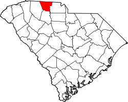
Gaffney is located in northern South Carolina near the center of Cherokee County. It is located 55 miles (89 km) southwest of Charlotte, North Carolina and 50 miles (80 km) northeast of Greenville.

According to the United States Census Bureau, Gaffney has a total area of 8.35 square miles (21.63 km2), of which 8.32 square miles (21.56 km2) is land and 0.03 square miles (0.07 km2), or 0.31%, is water. [6]

Demographics

Historical population
CensusPop.Note
1880 400
1890 1,631307.8%
1900 3,937141.4%
1910 4,76721.1%
1920 5,0656.3%
1930 6,82734.8%
1940 7,63611.9%
1950 8,1236.4%
1960 10,43528.5%
1970 13,25327.0%
1980 13,4531.5%
1990 13,145−2.3%
2000 12,968−1.3%
2010 12,539−3.3%
2020 12,7641.8%
U.S. Decennial Census [12] [4]

2020 census

Gaffney racial composition [13]
RaceNum.Perc.
White (non-Hispanic)5,79845.42%
Black or African American (non-Hispanic)5,76345.15%
Native American 370.29%
Asian 810.63%
Pacific Islander 80.06%
Other/Mixed 4583.59%
Hispanic or Latino 6194.85%

As of the 2020 United States census, there were 12,764 people, 4,220 households, and 2,116 families residing in the city.

2000 census

As of the census of 2000, there were 12,968 people, 5,304 households, and 3,336 families residing in the city. The population density was 1,649.7 inhabitants per square mile (637.0/km2). There were 5,765 housing units at an average density of 733.4 per square mile (283.2/km2). The racial makeup of the city was 50.48% White, 47.19% African American, 0.15% Native American, 0.45% Asian, 0.03% Pacific Islander, 0.99% from other races, and 0.71% from two or more races. Hispanic or Latino of any race were 1.98% of the population. [ citation needed ]

There were 5,304 households, out of which 26.8% had children under the age of 18 living with them, 37.1% were married couples living together, 21.6% had a female householder with no husband present, and 37.1% were non-families. 33.3% of all households were made up of individuals, and 14.2% had someone living alone who was 65 years of age or older. The average household size was 2.32 and the average family size was 2.96.[ citation needed ]

In the city, the population was spread out, with 23.4% under the age of 18, 10.8% from 18 to 24, 25.7% from 25 to 44, 22.6% from 45 to 64, and 17.5% who were 65 years of age or older. The median age was 38 years. For every 100 females, there were 82.1 males. For every 100 females age 18 and over, there were 78.7 males.[ citation needed ]

The median income for a household in the city was $29,480, and the median income for a family was $38,449. Males had a median income of $30,145 versus $22,167 for females. The per capita income for the city was $17,755. About 13.3% of families and 26.2% of the population were below the poverty line, including 19.2% of those under age 18 and 18.0% of those age 65 or over.[ citation needed ]

Arts and culture

Gaffney has a public library, a branch of the Cherokee County Library System. [14]

Located in the historic district of downtown Gaffney, is Harold's Restaurant, a diner founded in 1932 by Harold Tindall. [15] The diner was featured on Food Network's Diners, Drive-ins, and Dives and visited by host Guy Fieri in 2007. [16]

In 2008, the Cherokee County History and Arts Museum opened on the former mustering ground of the South Carolina militia (1812–1914), and is one of the city's three nationally registered historic sites.

Other historic sites listed in the National Register of Historic Places include Archeological Site 38CK1, Archeological Site 38CK44, Archeological Site 38CK45, Carnegie Free Library, Coopersville Ironworks Site (38CK2) and Susan Furnace Site (38CK67), Cowpens Furnace Site (38CK73), Winnie Davis Hall, Ellen Furnace Site (38CK68), Gaffney Commercial Historic District, Gaffney Residential Historic District, Irene Mill Finishing Plant, Jefferies House, Limestone Springs Historic District, Magness-Humphries House, Nesbitt's Limestone Quarry (38CK69), and Settlemyer House. [17]

Parks and recreation

The city's park system include a skatepark, two passive parks, and several children's playgrounds. [18]

Education

Limestone University Curtis Administration Building.jpg
Limestone University

Gaffney is served by the Cherokee County School District, which is one unified school district. Public schools in Gaffney include:

Private schools in Gaffney include:

Colleges & universities:

Media

Infrastructure

Peachoid water tower Peachoid-gaffney.png
Peachoid water tower

Transportation

Gaffney is located on the Interstate 85 corridor, linking it to Atlanta and Charlotte. U.S. Route 29 passes through the center of Gaffney.

Public transit is available through the Gaffney Cab Company.

The region is served by two airports, Greenville–Spartanburg International Airport, and Charlotte Douglas International Airport.

Water tower

The Peachoid water tower is a water tower shaped like a peach, and serves both artistic and practical functions.

Healthcare

Notable people

Fictional politician Frank Underwood, the protagonist of the Netflix series House of Cards , is a native of the city and its congressman in the U.S. House of Representatives (for South Carolina's 5th congressional district) and later President of the United States. The Peachoid was shown, and referred to in multiple episodes. [24] [25]

See also

Related Research Articles

<span class="mw-page-title-main">Washington County, Tennessee</span> County in Tennessee, United States

Washington County is a county located in the U.S. state of Tennessee. As of the 2020 census, the population was 133,001. Its county seat is Jonesborough. The county's largest city and a regional educational, medical and commercial center is Johnson City. Washington County is Tennessee's oldest county, having been established in 1777 when the state was still part of North Carolina. Washington County is part of the Johnson City, TN Metropolitan Statistical Area, which is a component of the Johnson City–Kingsport–Bristol, TN-VA Combined Statistical Area, commonly known as the "Tri-Cities" region.

<span class="mw-page-title-main">Monroe County, Tennessee</span> County in Tennessee, United States

Monroe County is a county located on the eastern border of the U.S. state of Tennessee. As of the 2020 census, the population was 46,250. Its county seat is Madisonville, and its largest city is Sweetwater.

<span class="mw-page-title-main">Spartanburg County, South Carolina</span> County in South Carolina, United States

Spartanburg County is a county located on the northwestern border of the U.S. state of South Carolina. As of the 2020 census, the population was 327,997, making it the fifth-most populous county in South Carolina. Its county seat is Spartanburg.

<span class="mw-page-title-main">Oconee County, South Carolina</span> County in South Carolina, United States

Oconee County is the westernmost county in the U.S. state of South Carolina. As of the 2020 census, the population was 78,607. Its county seat is Walhalla and its largest community is Seneca. Oconee County is included in the Seneca, SC Micropolitan Statistical Area, which is also included in the Greenville-Spartanburg-Anderson, SC Combined Statistical Area. South Carolina Highway 11, the Cherokee Foothills National Scenic Highway, begins in southern Oconee County at Interstate Highway 85 at the Georgia state line.

<span class="mw-page-title-main">Cherokee County, South Carolina</span> County in South Carolina, United States

Cherokee County is a county in the U.S. state of South Carolina. As of the 2020 census, the population was 56,216. The county seat is Gaffney. The county was formed in 1897 from parts of York, Union, and Spartanburg counties. It was named for the Cherokee people who historically occupied this area prior to European encounter.

<span class="mw-page-title-main">Hendersonville, North Carolina</span> City in North Carolina, United States

Hendersonville is a city in and the county seat of Henderson County, North Carolina, United States, located 22 miles (35 km) south of Asheville. Like the county, the city is named for 19th-century North Carolina Supreme Court Chief Justice Leonard Henderson.

<span class="mw-page-title-main">Cullowhee, North Carolina</span> Census-designated place in North Carolina, United States

Cullowhee is a census-designated place (CDP) in Jackson County, North Carolina, United States. It is located on the Tuckasegee River, and the permanent population was 7,682 at the 2020 census up from 6,228 at the 2010 census.

<span class="mw-page-title-main">Bryson City, North Carolina</span> Town in North Carolina, United States

Bryson City is a town in and the county seat of Swain County, North Carolina, United States. The population was 1,558 as of the 2020 census. Located in what was historically the land of the Cherokee, Bryson City was founded as Charleston to serve as the county seat of Swain County when it was formed from parts of surrounding counties. It grew into an important local rail hub. Today the city serves as a popular tourist destination, lying just to the west of the entrance to the Great Smoky Mountains National Park, for outdoor activities in the Nantahala National Forest, and along the Nantahala River and Fontana Lake, and serves as the home of the Great Smoky Mountains Railroad, a heritage railroad that provides tours of the Nantahala valley. The popular Nantahala Outdoor Center provides guide services for many of the outdoor activities in the area.

<span class="mw-page-title-main">Blacksburg, South Carolina</span> Town in South Carolina, United States

Blacksburg is a small town in Cherokee County, South Carolina, United States. The population was 1,848 at the 2010 census. The communities of Cherokee Falls, Kings Creek, Cashion Crossroads, Buffalo, and Mount Paran are located near the town.

<span class="mw-page-title-main">Ninety Six, South Carolina</span> Town in South Carolina, United States

Ninety Six is a town in Greenwood County, South Carolina, United States. The population was 1,998 at the 2010 census.

<span class="mw-page-title-main">Walhalla, South Carolina</span> City in South Carolina, United States

Walhalla is a city in the foothills of the Blue Ridge Mountains in Oconee County, South Carolina. Designated in 1868 as the county seat, it lies within the area of the Blue Ridge Escarpment, an area of transition between mountains and piedmont, and contains numerous waterfalls. It is located 16 miles (26 km) from Clemson University in Clemson, South Carolina.

<span class="mw-page-title-main">Pickens, South Carolina</span> City in South Carolina, United States

Pickens, formerly called Pickens Courthouse, is a city in and the county seat of Pickens County, South Carolina, United States. The population was 3,126 at the 2010 census. Pickens changed its classification from a town to a city in 1998, but it was not reported to the Census Bureau until 2001. It was named after Andrew Pickens (1739–1817), an American revolutionary soldier and US Congressman for South Carolina.

<span class="mw-page-title-main">Inman, South Carolina</span> City in South Carolina, United States

Inman is a city in Spartanburg County, South Carolina, United States, part of the Spartanburg metropolitan area. With a population of 3,665 at the 2020 census, Inman residents have access to nearby Lake Bowen that affords water recreational sports and fishing, and Inman is accessible by Interstate 26 and Interstate 85. The city contains a historic main street district, several houses of worship, and a school district.

<span class="mw-page-title-main">Spartanburg, South Carolina</span> City in South Carolina

Spartanburg is a city in and the seat of Spartanburg County, South Carolina, United States. The city had a population of 38,732 as of the 2020 census, making it the 11th-most populous city in the state. For a time, the Office of Management and Budget (OMB) grouped Spartanburg and Union counties together as the Spartanburg, SC Metropolitan Statistical Area, but the OMB now defines the Spartanburg, SC MSA as only Spartanburg County.

<span class="mw-page-title-main">Valley Falls, South Carolina</span> CDP in South Carolina, United States

Valley Falls is a census-designated place (CDP) in Spartanburg County, South Carolina, United States. The population was 6,299 at the 2010 census.

<span class="mw-page-title-main">Woodruff, South Carolina</span> City in South Carolina, United States

Woodruff is a city in Spartanburg County, South Carolina, United States, located in upstate South Carolina. The population was 4,333 at the 2020 census.

<span class="mw-page-title-main">Union, South Carolina</span> City in South Carolina, United States

The city of Union is the county seat of Union County, South Carolina, United States. The population was 8,393 at the 2010 census. It is the principal city of the Union Micropolitan Statistical Area, which includes all of Union County and which is further included in the greater Greenville-Spartanburg-Anderson, South Carolina Combined Statistical Area.

<span class="mw-page-title-main">Chesnee, South Carolina</span> City in South Carolina, United States

Chesnee is a city in Spartanburg and Cherokee counties, in the U.S. state of South Carolina. The population was 868 as of the 2010 census.

<span class="mw-page-title-main">Greer, South Carolina</span> City in South Carolina, United States

Greer is a city in Greenville and Spartanburg counties in the U.S. state of South Carolina. The population was 35,308 as of the 2020 census, making it the 14th-most populous city in South Carolina. Greer is included in the Greenville-Anderson-Greer, SC Metropolitan Statistical Area, which is part of the Greenville-Spartanburg-Anderson, SC Combined Statistical Area in Upstate South Carolina.

<span class="mw-page-title-main">Vonore, Tennessee</span> Town in Tennessee, United States

Vonore is a town in Monroe County, Tennessee, which is located on the southeast border of the state. The population was 1,574 as of the 2020 census. The city hall, library, community center, police department, and fire department are located on Church Street.

References

  1. "City Council | Gaffney, SC". www.cityofgaffney-sc.gov.
  2. "ArcGIS REST Services Directory". United States Census Bureau. Retrieved October 15, 2022.
  3. 1 2 U.S. Geological Survey Geographic Names Information System: Gaffney, South Carolina
  4. 1 2 "Census Population API". United States Census Bureau. Retrieved October 15, 2022.
  5. "Find a County". National Association of Counties. Archived from the original on May 31, 2011. Retrieved June 7, 2011.
  6. 1 2 "Geographic Identifiers: 2010 Census Summary File 1 (G001): Gaffney city, South Carolina (revision of 02-22-2013)". U.S. Census Bureau, American Factfinder. Archived from the original on February 13, 2020. Retrieved June 30, 2015.
  7. "Population and Housing Unit Estimates" . Retrieved May 21, 2020.
  8. Louise Pettus Archives and Special Collections, Winthrop University, "Michael Gaffney Biography 1775-1854 - Accession 132 - M59 (74)". Finding Aid 163. https://digitalcommons.winthrop.edu/manuscriptcollection_findingaids/163
  9. Black, John (September 28, 1958). "Michael Gaffney (1775-1854), Upstate Pioneer" (PDF). Spartanburg Herals. pp. 1–2. Retrieved August 13, 2023.
  10. PETERS, ROBERT W. DALTON and CRAIG. "Gaffney Strangler terrorized town 40 years ago, murdering 4 women". Spartanburg Herald Journal. Retrieved April 13, 2024.
  11. "Americas | US community fears serial killer". BBC News. July 5, 2009. Retrieved July 7, 2009.
  12. "U.S. Decennial Census". Census.gov. Retrieved June 4, 2013.
  13. "Explore Census Data". data.census.gov. Retrieved December 14, 2021.
  14. "South Carolina libraries and archives". SCIWAY. Retrieved June 7, 2019.
  15. "Harold's Restaurant: Gaffney fixture featured on Food Network". Spartanburg Herald Journal. Retrieved April 13, 2024.
  16. Bureau, JANET S. SPENCER Cherokee County. "Fieri salivates over fatback at Harold's". Spartanburg Herald Journal. Retrieved April 13, 2024.
  17. "National Register Information System". National Register of Historic Places . National Park Service. July 9, 2010.
  18. City of Gaffney, South Carolina (August 13, 2023). "City of Gaffney Parks". City of Gaffney, South Carolina, Website. Retrieved August 13, 2023.
  19. "Cherokee Medical Center - Spartanburg Regional Healthcare System". www.spartanburgregional.com. Retrieved January 28, 2019.
  20. Staff Reports (December 31, 2018). "Spartanburg Regional completes Mary Black acquisition". DiscoverHealth.org. Archived from the original on January 29, 2019. Retrieved January 28, 2019.
  21. "Cancer Treatment at Gibbs Cancer Center - Spartanburg Regional Healthcare System". www.spartanburgregional.com. Retrieved January 28, 2019.
  22. "MGC Immediate Care Center – Gaffney". www.medicalgroupofthecarolinas.com. Retrieved January 28, 2019.
  23. Green Design Advocate Neil Chambers Launches National Book Tour https://www.winthrop.edu/news-events/article.aspx?id=19549
  24. Chris Jancelewicz (February 26, 2013). "House Of Cards Season 1, Episode 3 Recap: Just Peachoid". The Huffington Post . Retrieved February 18, 2014.
  25. Stephen Largen (March 19, 2013). "Upstate town's giant peach is ripe for fame on Netflix drama 'House of Cards'". The Post and Courier . Charleston, South Carolina. Archived from the original on December 22, 2015. Retrieved February 22, 2014.