State Line, South Carolina

Last updated

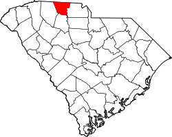
State Line is an unincorporated community in Cherokee County, in the U.S. state of South Carolina. [1]

History

A post office called State Line was established in 1875, and remained in operation until 1904. [2] The community was so named for its location near the South Carolina—North Carolina state line. [3]

Related Research Articles

<span class="mw-page-title-main">Monroe County, Tennessee</span> County in Tennessee, United States

<span class="mw-page-title-main">Blacksburg, South Carolina</span> Town in South Carolina, United States

Blacksburg is a small town in Cherokee County, South Carolina, United States. The population was 1,848 at the 2010 census. The communities of Cherokee Falls, Kings Creek, Cashion Crossroads, Buffalo, and Mount Paran are located near the town.

<span class="mw-page-title-main">East Gaffney, South Carolina</span> Census-designated place in South Carolina, United States

East Gaffney is a census-designated place (CDP) in Cherokee County, South Carolina, United States. The population was 3,085 at the 2010 United States Census.

<span class="mw-page-title-main">Gaffney, South Carolina</span> City in South Carolina, United States

Gaffney is a city in and the seat of Cherokee County, South Carolina, United States, in the Upstate region of South Carolina. Gaffney is known as the "Peach Capital of South Carolina". The population was 12,539 at the 2010 census, with an estimated population of 12,609 in 2019. It is the principal city of the Gaffney, South Carolina, Micropolitan Statistical Area, which includes all of Cherokee County and which is further included in the greater Greenville-Spartanburg-Anderson, South Carolina Combined Statistical Area.

<span class="mw-page-title-main">Ninety Six, South Carolina</span> Town in South Carolina, United States

Ninety Six is a town in Greenwood County, South Carolina, United States. The population was 1,998 at the 2010 census.

<span class="mw-page-title-main">Cowpens, South Carolina</span> Town in South Carolina, United States

Cowpens is a town in Spartanburg County, South Carolina, United States. The population was 2,162 at the 2010 census. The town was founded in 1876, and was incorporated in 1880.

<span class="mw-page-title-main">Smyrna, South Carolina</span> Town in South Carolina, United States

Smyrna is a small town in York and Cherokee counties in the U.S. state of South Carolina. The population was 45 at the 2010 United States Census,..

Tryon County is a former county which was located in the U.S. state of North Carolina. It was formed in 1768 from the part of Mecklenburg County west of the Catawba River, although the legislative act that created it did not become effective until April 10, 1769. Due to inaccurate and delayed surveying, Tryon County encompassed a large area of northwestern South Carolina. It was named for William Tryon, governor of the North Carolina Colony from 1765 to 1771.

<span class="mw-page-title-main">Crowders Mountain State Park</span> State park in North Carolina, United States

Crowders Mountain State Park is a 5,217-acre (21.11 km2) North Carolina state park in Gaston County, North Carolina in the United States. It is near Kings Mountain, North Carolina and on the outskirts of Gastonia, North Carolina, it includes the peaks of Crowder's Mountain and The Pinnacle. Crowders Mountain is named for Crowders Creek which originates near its base. The cliffs are a popular destination for rock climbers.

<span class="mw-page-title-main">Qualla Boundary</span> Land held in trust for the Cherokee of North Carolina

The Qualla Boundary or The Qualla is territory held as a land trust by the United States government for the federally recognized Eastern Band of Cherokee Indians, who reside in western North Carolina. The area is part of the large historic Cherokee territory in the Southeast, which extended into eastern Tennessee, western South Carolina, northern Georgia and Alabama. Currently, the largest contiguous portion of the Qualla lies in Haywood, Swain, and Jackson counties and is centered on the community of Cherokee, which serves as the tribal capital of the Eastern Band of Cherokee Indians. Smaller, discontiguous parcels also lie in Graham and Cherokee counties, near the communities of Snowbird and Murphy respectively.

Cherokee Falls is an unincorporated community in Cherokee County, South Carolina, United States. It is 5 miles (8 km) south of the town of Blacksburg. A former mill community along the Broad River, Cherokee Falls was a town until disincorporation in the 1990s. The former Cherokee Falls Cotton Mill is now a major fireworks distribution center for Herbie's Famous Fireworks.

<span class="mw-page-title-main">Broad River (Carolinas)</span> River in North and South Carolina, United States

The Broad River is a principal tributary of the Congaree River, about 150 miles (240 km) long, in western North Carolina and northern South Carolina in the United States. Via the Congaree, it is part of the watershed of the Santee River, which flows to the Atlantic Ocean.

<span class="mw-page-title-main">Thicketty, South Carolina</span> Unincorporated community in South Carolina, United States

Thicketty is an unincorporated community in Cherokee County, South Carolina, United States. It lies between Gaffney and Cowpens along U.S. Route 29. Thicketty is located approximately 12 miles (19 km) northeast of Spartanburg.

<span class="mw-page-title-main">Overhill Cherokee</span> 18th century Cherokee people who lived on the west side of the Appalachian Mountains

Overhill Cherokee was the term for the Cherokee people located in their historic settlements in what is now the U.S. state of Tennessee in the Southeastern United States, on the western side of the Appalachian Mountains. This name was used by 18th-century European traders and explorers from British colonies along the Atlantic coast, as they had to cross the mountains to reach these settlements.

Cherokee Springs is an unincorporated community in Spartanburg County, in the U.S. state of South Carolina.

Farmers is an unincorporated community in the southwest corner of Franklin Township, Owen County, in the U.S. state of Indiana. It lies just south of US Highway 231 at the intersection of 650 West, which is a community about twelve miles south of the city of Spencer, the county seat of Owen County. Its elevation is 591 feet, and it is located at 39°10′31″N86°53′30″W. This community is also known as Farmers Station.

Stone Station is an unincorporated community in Spartanburg County, in the U.S. state of South Carolina.

Ezell is a ghost town in Cherokee County, in the U.S. state of South Carolina.

Green Pond is an unincorporated community in Colleton County, in the U.S. state of South Carolina.

Kings Creek is an unincorporated community in Cherokee County, South Carolina, United States. It is located in the vicinity of South Carolina Highways 5 and 97. Situated nearby is the NRHP-designated King's Creek Furnace Site. The name of the community comes from a local settler named King who lived close to the locale on the namesake Kings Creek.

References

  1. U.S. Geological Survey Geographic Names Information System: State Line, South Carolina
  2. "Cherokee County". Jim Forte Postal History. Retrieved October 7, 2015.
  3. Foster, Julia H. (January 3, 1932). "Spartanburg County sees countless changes during 35-year period". Herald-Journal. p. 3. Retrieved October 7, 2015.
35°10′36″N81°48′00″W / 35.17667°N 81.80000°W / 35.17667; -81.80000