Cherokee County, South Carolina

Last updated

Cherokee County
Limestone College.png
Cherokee County Flag.gif
Cherokee County Seal, SC.webp
Map of South Carolina highlighting Cherokee County.svg
Location within the U.S. state of South Carolina
South Carolina in United States.svg
South Carolina's location within the U.S.
Coordinates: 35°03′N81°37′W / 35.05°N 81.61°W / 35.05; -81.61
CountryFlag of the United States.svg United States
StateFlag of South Carolina.svg  South Carolina
Founded1897
Named for Cherokee Indians
Seat Gaffney
Largest communityGaffney
Area
  Total397.47 sq mi (1,029.4 km2)
  Land392.96 sq mi (1,017.8 km2)
  Water4.51 sq mi (11.7 km2)  1.13%
Population
 (2020)
  Total56,216
  Estimate 
(2023)
56,714
  Density143.06/sq mi (55.24/km2)
Time zone UTC−5 (Eastern)
  Summer (DST) UTC−4 (EDT)
Congressional district 5th
Website www.cherokeecountysc.com

Cherokee County is a county in the U.S. state of South Carolina. As of the 2020 census, the population was 56,216. [1] The county seat is Gaffney. [2] The county was formed in 1897 from parts of York, Union, and Spartanburg counties. It was named for the Cherokee people who historically occupied this area prior to European encounter. [3]

Contents

Cherokee County comprises the Gaffney, SC Micropolitan Statistical Area, which is also included in the Greenville-Spartanburg-Anderson, SC Combined Statistical Area.

History

This area was occupied for thousands of years by indigenous peoples and by the historic Cherokee people before the arrival of Europeans.

When European traders and settlers entered the area, they used the existing Native American paths: called collectively the Trading Path. The Upper Road and Lower Cherokee Traders Path were paths that passed through the piedmont. The former connected to Fredericksburg, Virginia, leading from the Virginia Tidewater, into the Piedmont, and continue down further South.

The Lower Cherokee Traders Path especially connected areas in present-day western North Carolina, upstate South Carolina and northeastern Georgia. In the mid-18th century, waves of British migrants and immigrants, an estimated 250,000 people, traveled by these paths into Cherokee and neighboring counties in the piedmont. This backcountry area was initially settled especially by immigrant Ulster Scots people, along with Germans and Anglo-Americans migrating into the area. Up until the mid-19th century, plantations were developed in the county. Enslaved African-Americans, for their labor, and as “property,” were the basis of the county's economy until the end of the Civil War.

During the American Revolutionary War, the Battle of Cowpens was fought on January 17, 1781, in northwestern Cherokee County, north of the town of Cowpens, South Carolina, an engagement in the American Revolution's southern theatre resulting in a Patriot victory.

Geography

Cherokee County, South Carolina
Interactive map of Cherokee County

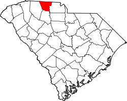
According to the U.S. Census Bureau, the county has a total area of 397.47 square miles (1,029.4 km2), of which 392.96 square miles (1,017.8 km2) is land and 4.51 square miles (11.7 km2) (1.13%) is water. [4] It is the third-smallest county in South Carolina by land area and fourth-smallest by total area.

Mountain peaks

Draytonville Mountain is known to locals as McKown's Mountain, named for a farmer who owned much of the land in that area.

Major water bodies

National protected areas

State and local protected areas/sites

Adjacent counties

Demographics

Historical population
CensusPop.Note
1900 21,359
1910 26,17922.6%
1920 27,5705.3%
1930 32,20116.8%
1940 33,2903.4%
1950 34,9925.1%
1960 35,2050.6%
1970 36,7914.5%
1980 40,98311.4%
1990 44,5068.6%
2000 52,53718.0%
2010 55,3425.3%
2020 56,2161.6%
2023 (est.)56,714 [1] 0.9%
U.S. Decennial Census [6]
1790–1960 [7] 1900–1990 [8]
1990–2000 [9] 2010 [10] 2020 [1]

2020 census

Cherokee County racial composition [11]
RaceNum.Perc.
White (non-Hispanic)39,57670.4%
Black or African American (non-Hispanic)11,29220.09%
Native American 1610.29%
Asian 3410.61%
Pacific Islander 140.02%
Other/Mixed 2,0553.66%
Hispanic or Latino 2,7774.94%

As of the 2020 census, there were 56,216 people, 20,699 households, and 11,592 families residing in the county.

2010 census

At the 2010 census, there were 55,342 people, 21,519 households, and 14,941 families residing in the county. [12] [10] The population density was 140.9 inhabitants per square mile (54.4/km2). There were 23,997 housing units at an average density of 61.1 per square mile (23.6/km2). [13] The racial makeup of the county was 75.0% white, 20.4% black or African American, 0.6% Asian, 0.4% American Indian, 2.2% from other races, and 1.4% from two or more races. Those of Hispanic or Latino origin made up 3.7% of the population. [12] In terms of ancestry, 14.7% were American, 9.7% were Irish, 6.6% were English, and 6.5% were German. [14]

Of the 21,519 households, 35.1% had children under the age of 18 living with them, 46.2% were married couples living together, 17.4% had a female householder with no husband present, 30.6% were non-families, and 25.8% of all households were made up of individuals. The average household size was 2.54 and the average family size was 3.03. The median age was 38.3 years. [12]

The median income for a household in the county was $34,132 and the median income for a family was $46,164. Males had a median income of $39,048 versus $27,390 for females. The per capita income for the county was $17,862. About 14.3% of families and 19.5% of the population were below the poverty line, including 27.5% of those under age 18 and 11.0% of those age 65 or over. [15]

2000 census

At the 2000 census, [16] there were 52,537 people, 20,495 households, and 14,612 families residing in the county. The population density was 134 people per square mile (52 people/km2). There were 22,400 housing units at an average density of 57 per square mile (22/km2). The racial makeup of the county was 76.92% White, 20.56% Black or African American, 0.20% Native American, 0.31% Asian, 0.02% Pacific Islander, 1.16% from other races, and 0.84% from two or more races. 2.08% of the population were Hispanic or Latino of any race. 39.1% were of "American", 6.8% Irish, 5.8% English and 5.6% German ancestry according to Census 2000. Most of those claiming "American" ancestry are of Scots-Irish and/or English descent, but have family who have been in the country for so long, that they no longer differentiate such national origins and choose to identify simply as "American". [17] [18] [19] [20] [21]

There were 20,495 households, out of which 32.70% had children under the age of 18 living with them, 51.30% were married couples living together, 15.40% had a female householder with no husband present, and 28.70% were non-families. 25.00% of all households were made up of individuals, and 9.40% had someone living alone who was 65 years of age or older. The average household size was 2.53 and the average family size was 3.01.

In the county, the population was spread out, with 25.80% under the age of 18, 9.00% from 18 to 24, 29.60% from 25 to 44, 23.20% from 45 to 64, and 12.40% who were 65 years of age or older. The median age was 35 years. For every 100 females there were 93.80 males. For every 100 females age 18 and over, there were 90.70 males.

The median income for a household in the county was $33,787, and the median income for a family was $39,393. Males had a median income of $30,984 versus $21,298 for females. The per capita income for the county was $16,421. About 11.00% of families and 23.90% of the population were below the poverty line, including 16.90% of those under age 18 and 15.20% of those age 65 or over. [22]

Government and politics

United States presidential election results for Cherokee County, South Carolina [23]
Year Republican Democratic Third party
No.%No.%No.%
2020 18,04371.40%6,98327.63%2440.97%
2016 15,16769.70%6,09228.00%5002.30%
2012 13,31464.09%7,23134.81%2281.10%
2008 13,30564.07%7,21534.74%2461.18%
2004 12,09064.60%6,46634.55%1580.84%
2000 9,90060.65%6,13837.60%2851.75%
1996 6,68949.04%5,82142.68%1,1298.28%
1992 6,88747.31%5,45337.46%2,21715.23%
1988 7,76363.89%4,32235.57%660.54%
1984 8,65567.57%4,10132.02%530.41%
1980 5,37943.32%6,88955.48%1501.21%
1976 3,93133.51%7,76566.19%360.31%
1972 7,57077.24%2,10721.50%1231.26%
1968 2,85327.19%1,99819.04%5,64253.77%
1964 3,62746.00%4,25854.00%00.00%
1960 1,56522.50%5,39177.50%00.00%
1956 90718.50%3,68775.21%3086.28%
1952 1,52921.61%5,54578.39%00.00%
1948 774.38%60534.41%1,07661.21%
1944 683.95%1,62094.13%331.92%
1940 361.71%2,06998.29%00.00%
1936 231.00%2,28099.00%00.00%
1932 371.54%2,36398.38%20.08%
1928 896.03%1,38893.97%00.00%
1924 241.97%1,18697.53%60.49%
1920 482.64%1,77197.36%00.00%
1916 130.99%1,27196.36%352.65%
1912 161.25%1,25998.21%70.55%
1904 312.02%1,50797.98%00.00%
1900 595.16%1,08494.84%00.00%

Economy

Cherokee County is the only county to have three national parks within its boundaries: the Overmountain Victory National Historic Trail, Kings Mountain National Military Park and Cowpens National Battlefield. [24] Several historic homes dot the landscape of Cherokee County. While many are not generally open to the public, several annual tours of these homes take place. [25]

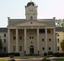
Gaffney Little Theatre and Limestone College serve theater enthusiasts, offering plays and musicals ten to twelve times a year.

Located outside the city of Gaffney is the Cherokee Speedway, a 3/8th mile dirt racing track that hosts several short track stock car racing events. Originally constructed in the 1950s, it has had notable early racecar drivers like Bobby Isaac and Curtis Turner compete there. [26]

A major shopping center is Prime Outlets-Gaffney, which attracts almost 3,000,000 visitors per year, and contains over 80 retail outlets. Floyd Baker Boulevard is a major commercial area in Gaffney. It has numerous stores and restaurants. Uptown Gaffney offers many upscale boutiques, shops and cafes. [27]

The area's newest attraction is the Cherokee County History and Arts Museum. It is located at the old Central School. Cherokee County's history, its contributions to the arts, and its role in shaping the culture of the southeast are explored. [28]

Nuclear power plant

In 2002, the President George W. Bush administration initiated the Nuclear Power 2010 Program, to encourage development of nuclear power plants to meet energy needs. The program developed streamlining of approval processes for licensing and had subsidies. Additional incentives were authorized under the Nuclear Power Act of 2005.

On March 16, 2006 Duke Power announced that a Cherokee County site had been selected for a potential new nuclear power plant, to be called the William States Lee III Nuclear Generating Station, informally known as Lee Station. The site is jointly owned by Duke Power and Southern Company. Duke plans to develop the site for two Westinghouse Electric Company AP1000 (advanced passive) pressurized water reactors. Each reactor is capable of producing approximately 1,117 megawatts. (See Nuclear Power 2010 Program.) This site is adjacent to the old Cherokee Nuclear Power Plant site, which was never completed and ultimately abandoned. It was used by James Cameron as a set for the 1989 film The Abyss .

On December 14, 2007 Duke Power submitted a Combined Construction and Operating License to the Nuclear Regulatory Commission, with an announcement that it will spend $160 million in 2008 on the plant with a total cost of 5–6 billion dollars. [29] Due to a slowdown in licensing and increase in costs, a federal license for what is estimated to be an $11 billion plant is not expected until 2016. Duke Energy will decide after that point whether to go forward with construction. [30] In August 2017, Duke Energy announced that construction plans at the site had been put on an indefinite hold. The company retains the rights to restart construction in the future. [31]

Transportation

The lifeline of Cherokee County, I-85, runs through the city limits of Gaffney. It carries traffic and trade contributing to the business development along Floyd Baker Blvd, the county's main thoroughfare, which bisects I-85. Much of the county's growth occurs along I-85.

With no airports of its own, Cherokee County is served by Charlotte Douglas International Airport and Greenville-Spartanburg International Airport. A study to determine the feasibility of building an airport in the county revealed that an airport is desperately needed by businesses. Previous studies have determined the structure of the airport and possible airport sites have been narrowed down to two sites – one located just south of Gaffney and one located outside of Blacksburg. A major economic feasibility study is now being conducted, as required for funding by the federal government. If the airport is economically viable, the government could contribute 95% of the funds needed to construct the airport, if the project is authorized by Congress. If the study fails, then no federal funding will be provided. [32]

Major highways

Healthcare

Gaffney is home to several healthcare institutions:

Cherokee Medical Center

Cherokee Medical Center, a division of Spartanburg Regional Healthcare System, is a 125-bed acute care facility located in Gaffney, S.C., that services Cherokee County and the surrounding areas. [33] The hospital provides services including emergency, medical, surgical and imaging. Formerly Gaffney Medical Center, the hospital joined Mary Black Health System in 2015 and became Mary Black Health System – Gaffney. Mary Black facilities became part of Spartanburg Regional Healthcare System in 2019. [34]

Gibbs Cancer Center and Research Institute at Gaffney

Based in Spartanburg, Gibbs Cancer Center & Research Institute provides comprehensive cancer care to the Upstate South Carolina community and beyond. One of four locations, Gibbs at Gaffney opened in September 2011 with the mission of providing oncology services to the Cherokee County community.

Gibbs at Gaffney provides medical oncology and infusion services. [35]

Immediate Care Center – Gaffney

Located on Floyd Baker Boulevard, Immediate Care Center – Gaffney provides a hybrid of urgent and primary care. [36]

Medical Group of the Carolinas

A network of more than 100 practices in Upstate South Carolina, Medical Group of the Carolinas includes several medical practices in Cherokee County. The local offices include family and internal medicine, cardiology, orthopaedics, hematology oncology, urology and women's care. [37]

Communities

Cities

Towns

Census-designated places

Other unincorporated communities

Ghost towns

See also

Related Research Articles

<span class="mw-page-title-main">York County, South Carolina</span> County in South Carolina, United States

York County is a county on the north central border in the U.S. state of South Carolina. As of the 2020 census, the population was 282,090, making it the seventh-most populous county in the state. Its county seat is the city of York, and its most populous community is Rock Hill. The county is served by one Interstate Highway, Interstate 77.

<span class="mw-page-title-main">Union County, South Carolina</span> County in South Carolina, United States

Union County is a county located in the U.S. state of South Carolina. As of the 2020 census, the population was 27,244. Its county seat is Union. The county was created in 1785.

<span class="mw-page-title-main">Spartanburg County, South Carolina</span> County in South Carolina, United States

Spartanburg County is a county located on the northwestern border of the U.S. state of South Carolina. As of the 2020 census, the population was 327,997, making it the fifth-most populous county in South Carolina. Its county seat is Spartanburg.

<span class="mw-page-title-main">Oconee County, South Carolina</span> County in South Carolina, United States

Oconee County is the westernmost county in the U.S. state of South Carolina. As of the 2020 census, the population was 78,607. Its county seat is Walhalla and its largest community is Seneca. Oconee County is included in the Seneca, SC Micropolitan Statistical Area, which is also included in the Greenville-Spartanburg-Anderson, SC Combined Statistical Area. South Carolina Highway 11, the Cherokee Foothills National Scenic Highway, begins in southern Oconee County at Interstate Highway 85 at the Georgia state line.

<span class="mw-page-title-main">Marlboro County, South Carolina</span> County in South Carolina, United States

Marlboro County is a county located in the Pee Dee region on the northern border of the U.S. state of South Carolina. As of the 2020 census, its population was 26,667. Its county seat is Bennettsville. The Great Pee Dee River runs through it.

<span class="mw-page-title-main">Greenwood County, South Carolina</span> County in South Carolina, United States

Greenwood County is a county located in the U.S. state of South Carolina. As of the 2020 census, its population was 69,351. Its county seat is Greenwood.

<span class="mw-page-title-main">Greenville County, South Carolina</span> County in South Carolina, United States

Greenville County is located in the U.S. state of South Carolina. As of the 2020 census, the population was 525,534, making it the most populous county in the state. Its county seat is Greenville. The county is also home to the Greenville County School District, the largest school system in South Carolina.

<span class="mw-page-title-main">Bamberg County, South Carolina</span> County in South Carolina, United States

Bamberg County is a county located in the southwestern portion of U.S. state of South Carolina. As of the 2020 census, the population was 13,311, making the rural county the fourth-least populous of any in South Carolina. Its county seat is Bamberg.

<span class="mw-page-title-main">Abbeville County, South Carolina</span> County in South Carolina, United States

Abbeville County is a county located in the U.S. state of South Carolina. As of the 2020 census, its population was 24,295. Its county seat is Abbeville. It is the first county in the United States alphabetically. Abbeville County included in the Greenville-Spartanburg-Anderson, SC Combined Statistical Area.

<span class="mw-page-title-main">Blacksburg, South Carolina</span> Town in South Carolina, United States

Blacksburg is a small town in Cherokee County, South Carolina, United States. The population was 1,848 at the 2010 census. The communities of Cherokee Falls, Kings Creek, Cashion Crossroads, Buffalo, and Mount Paran are located near the town.

<span class="mw-page-title-main">Gaffney, South Carolina</span> City in South Carolina, United States

Gaffney is a city in and the seat of Cherokee County, South Carolina, United States, in the Upstate region of South Carolina. Gaffney is known as the "Peach Capital of South Carolina". The population was 12,539 at the 2010 census, with an estimated population of 12,609 in 2019. It is the principal city of the Gaffney, South Carolina, Micropolitan Statistical Area, which includes all of Cherokee County and which is further included in the greater Greenville-Spartanburg-Anderson, South Carolina Combined Statistical Area.

<span class="mw-page-title-main">Pickens, South Carolina</span> City in South Carolina, United States

Pickens, formerly called Pickens Courthouse, is a city in and the county seat of Pickens County, South Carolina, United States. The population was 3,126 at the 2010 census. Pickens changed its classification from a town to a city in 1998, but it was not reported to the Census Bureau until 2001. It was named after Andrew Pickens (1739–1817), an American revolutionary soldier and US Congressman for South Carolina.

<span class="mw-page-title-main">Boiling Springs, South Carolina</span> CDP in South Carolina, United States

Boiling Springs is a census-designated place (CDP) in Spartanburg County, South Carolina, United States. The population was 8,219 at the 2010 census.

<span class="mw-page-title-main">Cowpens, South Carolina</span> Town in South Carolina, United States

Cowpens is a town in Spartanburg County, South Carolina, United States. The population was 2,162 at the 2010 census. The town was chartered February 20, 1880, and was incorporated in 1900.

<span class="mw-page-title-main">Roebuck, South Carolina</span> CDP in South Carolina, United States

Roebuck is a census-designated place (CDP) in Spartanburg County, South Carolina, United States. The population was 2,200 at the 2010 census.

<span class="mw-page-title-main">Saxon, South Carolina</span> CDP in South Carolina, United States

Saxon is a census-designated place (CDP) in Spartanburg County, South Carolina, United States. The population was 3,424 at the 2010 census.

<span class="mw-page-title-main">Spartanburg, South Carolina</span> City in South Carolina

Spartanburg is a city in and the seat of Spartanburg County, South Carolina, United States. The city had a population of 38,732 as of the 2020 census, making it the 11th-most populous city in the state. For a time, the Office of Management and Budget (OMB) grouped Spartanburg and Union counties together as the Spartanburg, SC Metropolitan Statistical Area, but the OMB now defines the Spartanburg, SC MSA as only Spartanburg County.

<span class="mw-page-title-main">Valley Falls, South Carolina</span> CDP in South Carolina, United States

Valley Falls is a census-designated place (CDP) in Spartanburg County, South Carolina, United States. The population was 6,299 at the 2010 census.

<span class="mw-page-title-main">Chesnee, South Carolina</span> City in South Carolina, United States

Chesnee is a city in Spartanburg and Cherokee counties, in the U.S. state of South Carolina. The population was 868 as of the 2010 census.

<span class="mw-page-title-main">Greer, South Carolina</span> City in South Carolina, United States

Greer is a city in Greenville and Spartanburg counties in the U.S. state of South Carolina. The population was 35,308 as of the 2020 census, making it the 14th-most populous city in South Carolina. Greer is included in the Greenville-Anderson-Greer, SC Metropolitan Statistical Area, which is part of the Greenville-Spartanburg-Anderson, SC Combined Statistical Area in Upstate South Carolina.

References

  1. 1 2 3 "QuickFacts: Cherokee County, South Carolina". United States Census Bureau. Retrieved March 22, 2024.
  2. "Find a County". National Association of Counties. Archived from the original on May 9, 2015. Retrieved June 7, 2011.
  3. Federal Writers' Project (1941). Palmetto Place Names. Sloane Printing Co. p. 13.
  4. "2020 County Gazetteer Files – South Carolina". United States Census Bureau. August 23, 2022. Retrieved September 10, 2023.
  5. "SCDNR Public Lands". www2.dnr.sc.gov. Retrieved April 1, 2023.
  6. "U.S. Decennial Census". United States Census Bureau. Retrieved March 16, 2015.
  7. "Historical Census Browser". University of Virginia Library. Archived from the original on August 11, 2012. Retrieved March 16, 2015.
  8. Forstall, Richard L., ed. (March 27, 1995). "Population of Counties by Decennial Census: 1900 to 1990". United States Census Bureau. Retrieved March 16, 2015.
  9. "Census 2000 PHC-T-4. Ranking Tables for Counties: 1990 and 2000" (PDF). United States Census Bureau. April 2, 2001. Archived (PDF) from the original on October 9, 2022. Retrieved March 16, 2015.
  10. 1 2 "State & County QuickFacts". United States Census Bureau. Archived from the original on June 10, 2006. Retrieved November 22, 2013.
  11. "Explore Census Data". data.census.gov. Retrieved December 14, 2021.
  12. 1 2 3 "DP-1 Profile of General Population and Housing Characteristics: 2010 Demographic Profile Data". United States Census Bureau. Archived from the original on February 13, 2020. Retrieved March 9, 2016.
  13. "Population, Housing Units, Area, and Density: 2010 – County". United States Census Bureau. Archived from the original on February 13, 2020. Retrieved March 9, 2016.
  14. "DP02 SELECTED SOCIAL CHARACTERISTICS IN THE UNITED STATES – 2006–2010 American Community Survey 5-Year Estimates". United States Census Bureau. Archived from the original on February 13, 2020. Retrieved March 9, 2016.
  15. "DP03 SELECTED ECONOMIC CHARACTERISTICS – 2006–2010 American Community Survey 5-Year Estimates". United States Census Bureau. Archived from the original on February 13, 2020. Retrieved March 9, 2016.
  16. "U.S. Census website". United States Census Bureau . Retrieved May 14, 2011.
  17. Sharing the Dream: White Males in a Multicultural America By Dominic J. Pulera.
  18. Reynolds Farley, 'The New Census Question about Ancestry: What Did It Tell Us?', Demography, Vol. 28, No. 3 (August 1991), pp. 414, 421.
  19. Stanley Lieberson and Lawrence Santi, 'The Use of Nativity Data to Estimate Ethnic Characteristics and Patterns', Social Science Research, Vol. 14, No. 1 (1985), pp. 44–6.
  20. Stanley Lieberson and Mary C. Waters, 'Ethnic Groups in Flux: The Changing Ethnic Responses of American Whites', Annals of the American Academy of Political and Social Science, Vol. 487, No. 79 (September 1986), pp. 82–86.
  21. Mary C. Waters, Ethnic Options: Choosing Identities in America (Berkeley: University of California Press, 1990), p. 36.
  22. "Archived copy". Archived from the original on September 17, 2011. Retrieved December 5, 2017.{{cite web}}: CS1 maint: archived copy as title (link)
  23. Leip, David. "Dave Leip's Atlas of U.S. Presidential Elections". uselectionatlas.org. Retrieved March 13, 2018.
  24. "National Parks in South Carolina". Everything Everywhere. May 7, 2017. Retrieved June 12, 2022.
  25. "National Register Sites in Cherokee County". www.nationalregister.sc.gov. Retrieved June 12, 2022.
  26. Staff Writer (July 15, 1989). "Down in the dirt GAFFNEY". Spartanburg Herald-Journal. Retrieved April 12, 2024.
  27. "Gaffney Historical Marker". www.hmdb.org. Retrieved June 12, 2022.
  28. Society, Cherokee Historical and Preservation. "Museum". Cherokee Historical and Preservation Society. Retrieved June 12, 2022.
  29. "UPDATE 1-Duke Energy files to build new nuclear power plant". Reuters. December 13, 2007.
  30. "Duke Energy won't buy into SC nuclear plant [Santee Cooper]" Archived December 29, 2014, at the Wayback Machine , Charlotte Observer, January 27, 2014, accessed December 28, 2014
  31. "Duke Seeks To Cancel William States Lee Nuclear Power Project – News – Nuclear Power News – Nuclear Street – Nuclear Power Plant News, Jobs, and Careers". nuclearstreet.com. Retrieved August 27, 2017.
  32. ohtadmin (October 30, 2020). "Airport again a hot topic for county council – The Gaffney Ledger". The Gaffney Ledger -. Retrieved June 12, 2022.
  33. "Cherokee Medical Center – Spartanburg Regional Healthcare System". www.spartanburgregional.com. Retrieved January 28, 2019.
  34. Staff Reports (December 31, 2018). "Spartanburg Regional completes Mary Black acquisition". DiscoverHealth.org. Archived from the original on January 29, 2019. Retrieved January 28, 2019.
  35. "Cancer Treatment at Gibbs Cancer Center – Spartanburg Regional Healthcare System". www.spartanburgregional.com. Retrieved January 28, 2019.
  36. "Immediate Care Centers – Spartanburg Regional Healthcare System". www.spartanburgregional.com. Retrieved January 28, 2019.
  37. "Medical Group of the Carolinas". www.medicalgroupofthecarolinas.com. Archived from the original on January 29, 2019. Retrieved January 28, 2019.