Westminster, South Carolina

Last updated

Westminster, South Carolina
Westminster South Carolina.jpg
Southern Railways historic passenger depot
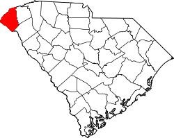
Oconee County South Carolina incorporated and unincorporated areas Westminster highlighted.svg
Location in Oconee County and the state of South Carolina.
Coordinates: 34°39′59″N83°5′43″W / 34.66639°N 83.09528°W / 34.66639; -83.09528
CountryUnited States
State South Carolina
County Oconee
Area
[1]
  Total3.45 sq mi (8.94 km2)
  Land3.45 sq mi (8.93 km2)
  Water0.00 sq mi (0.01 km2)
Elevation
[2]
929 ft (283 m)
Population
 (2020) [3]
  Total2,353
  Density682.82/sq mi (263.60/km2)
Time zone UTC−5 (Eastern (EST))
  Summer (DST) UTC−4 (EDT)
ZIP code
29693
Area code 864
FIPS code 45-76165 [4]
GNIS feature ID1227504 [2]
Website www.westminstersc.org

Westminster is a city in Oconee County, South Carolina, United States. The population was 2,418 at the 2010 census.

Contents

History

Westminster was founded in 1874 upon completion of the Atlanta and Richmond Air-Line Railway and incorporated on March 17, 1875 when the charter was signed. [5] It was founded as a water stop on the Southern Railway. [6] As stores, shops and factories started to set up around the train stop, it bloomed into a decent-sized town. Its peak of expansion came in the 1920s.

The Retreat Rosenwald School and Southern Railway Passenger Station are listed on the National Register of Historic Places. [7] [8]

The Apple Festival is celebrated annually. [9]

Geography

Westminster is located at 34°39′59″N83°5′43″W / 34.66639°N 83.09528°W / 34.66639; -83.09528 (34.666292, -83.095352). [10]

According to the United States Census Bureau, the city has a total area of 3.4 square miles (8.9 km2), all land.

Located in the foothills of the Blue Ridge Mountains, Westminster is surrounded by several rivers, 150 waterfalls, and two major lakes.

Demographics

Historical population
CensusPop.Note
1880 162
1890 532228.4%
1900 85761.1%
1910 1,57683.9%
1920 1,84717.2%
1930 1,774−4.0%
1940 2,01413.5%
1950 2,21910.2%
1960 2,4138.7%
1970 2,5214.5%
1980 3,11423.5%
1990 3,1200.2%
2000 2,743−12.1%
2010 2,418−11.8%
2020 2,353−2.7%
U.S. Decennial Census [11] [3]

2020 census

Westminster racial composition [12]
RaceNum.Perc.
White (non-Hispanic)1,84678.45%
Black or African American (non-Hispanic)2058.71%
Native American 20.08%
Asian 80.34%
Other/Mixed 1375.82%
Hispanic or Latino 1556.59%

As of the 2020 United States census, there were 2,353 people, 1,076 households, and 630 families residing in the city.

2000 census

As of the census [4] of 2000, there were 2,743 people, 1,191 households, and 761 families residing in the city. The population density was 796.6 inhabitants per square mile (307.6/km2). There were 1,333 housing units at an average density of 387.1 per square mile (149.5/km2). The racial makeup of the city was 85.60% White, 11.81% African American, 0.04% Native American, 0.18% Asian, 1.20% from other races, and 1.17% from two or more races. Hispanic or Latino of any race were 2.48% of the population.

There were 1,191 households, out of which 26.9% had children under the age of 18 living with them, 44.7% were married couples living together, 14.6% had a female householder with no husband present, and 36.1% were non-families. 32.2% of all households were made up of individuals, and 13.9% had someone living alone who was 65 years of age or older. The average household size was 2.30 and the average family size was 2.90.

In the city, the population was spread out, with 23.5% under the age of 18, 9.6% from 18 to 24, 27.0% from 25 to 44, 24.6% from 45 to 64, and 15.3% who were 65 years of age or older. The median age was 38 years. For every 100 females, there were 89.6 males. For every 100 females age 18 and over, there were 84.0 males.

The median income for a household in the city was $30,802, and the median income for a family was $36,678. Males had a median income of $30,104 versus $21,690 for females. The per capita income for the city was $17,121. About 6.8% of families and 9.3% of the population were below the poverty line, including 14.2% of those under age 18 and 9.8% of those age 65 or over.

Economy

Westminster is home to several industries; among them are: US Engine Valve plant, Ulbrich(flat wire manufacturing plant), and Sandvik Tooling Supply, a global supplier of tungsten carbide cutting tools.

Education

West-Oak High School is the public high school that most students from Westminster attend. The school draws students from across one half of Oconee County. The city also offers several elementary schools: Westminster Elementary, Orchard Park Elementary, and Fair Oak Elementary. Westminster Elementary and Orchard Park Elementary are both pre-kindergarten to 5th grade, though Fair Oak different because it is pre-kindergarten to 3rd grade and then the students transfer over to Fair Oak Intermediate for 4th and 5th grade. Oakway Intermediate is now closed and Fair Oak services Pre-K to 5th. The town also offers a middle school for grades 6 to 8. [13]

Westminster has a lending library, a branch of the Oconee County Public Library. [14]

Arts and culture

Annual culture events

Westminster is the home of the South Carolina Apple Festival. The annual celebration is held during the first two weeks of September, and features a parade, street vendors and booths, a rodeo, and other family activities. [15] Westminster and the nearby community of Long Creek have several commercial apple orchards. [16]

Westminster hosts the South Carolina Bigfoot Festival each October. [17]

Westminster welcomes car enthusiasts and is a very popular 'cruising' destination where people come from all over the tri-state area to cruise town and show off their vehicles. Westminster proudly holds the title, "The Southeast's Cruising Destination."

April - October, the town has Music on Main where Main Street is roped off and a stage is set up for musicians to perform live.

In April and September of each year, "pickers" from near and far gather on Main Street for the Westminster Bluegrass Jam. An event where people bring their instruments and gather on the street to play music together. [17]

There is also a Christmas Parade, Veterans Day Parade, and Apple Festival Parade each year on Main Street.

Museums and other points of interest

The train depot, which is on the National Register of Historic Places, burned due to vandalism in 2005. It has been rebuilt.

Oconee Heritage Center General Store Museum is located on Main St. in Downtown Westminster. This museum displays a vast collection of original artifacts from the historic England's General Merchandise store of Westminster and features exhibits on the history of the greater Westminster, SC, area.

Gateway Arts Center is located on Windsor Street, just one block off main, and offers gallery showings, youth camps andafter school programs. [17]

Westminster has their own recreation department located on Anderson Avenue. [18]

Education

Notable people

Related Research Articles

<span class="mw-page-title-main">Pickens County, South Carolina</span> County in South Carolina, United States

Pickens County is located in the northwest part of the U.S. state of South Carolina. As of the 2020 census, its population was 131,404. Its county seat is Pickens. The county was created in 1826. It is part of the Greenville-Anderson-Greer, SC Metropolitan Statistical Area.

<span class="mw-page-title-main">Oconee County, South Carolina</span> County in South Carolina, United States

Oconee County is the westernmost county in the U.S. state of South Carolina. As of the 2020 census, the population was 78,607. Its county seat is Walhalla and its largest community is Seneca. Oconee County is included in the Seneca, SC Micropolitan Statistical Area, which is also included in the Greenville-Spartanburg-Anderson, SC Combined Statistical Area. South Carolina Highway 11, the Cherokee Foothills National Scenic Highway, begins in southern Oconee County at Interstate Highway 85 at the Georgia state line.

<span class="mw-page-title-main">South San Gabriel, California</span> Census-designated place in California, United States

South San Gabriel is a census-designated place (CDP) in Los Angeles County, California, United States. The population was 8,070 at the 2010 census, up from 7,595 at the 2000 census.

<span class="mw-page-title-main">Kendallville, Indiana</span> City in Indiana, United States

Kendallville is a city in Wayne Township, Noble County, in the U.S. state of Indiana. The population was 10,205 at the 2021 census.

<span class="mw-page-title-main">Westminster, Maryland</span> City in Maryland, United States

Westminster is a city in and the county seat of Carroll County, Maryland, United States. The city's population was 19,960 at the 2020 census. Westminster is an outlying community in the Baltimore metropolitan area, which is part of the greater Washington–Baltimore combined statistical area.

<span class="mw-page-title-main">Cottage Grove, Minnesota</span> City in Minnesota, United States

Cottage Grove is a city 10 miles (16 km) south of Saint Paul in Washington County in the State of Minnesota. It lies on the north bank of the Mississippi River, north of the confluence with the St. Croix River. Cottage Grove and nearby suburbs form the southeast portion of Minneapolis-Saint Paul, the 16th-largest metropolitan area in the United States, with about 3.69 million residents. Its population was 38,839 at the 2020 census.

<span class="mw-page-title-main">Four Oaks, North Carolina</span> Town in North Carolina, United States

Four Oaks is a town in Johnston County, North Carolina, United States. As of the 2010 census it had a population of 1,921, up from 1,424 in 2000.

<span class="mw-page-title-main">Swansboro, North Carolina</span> Town in North Carolina, United States

Swansboro is a town in Onslow County, North Carolina, United States, located along the Crystal Coast. In 2020, the population was 3,744.

<span class="mw-page-title-main">Brevard, North Carolina</span> City in North Carolina, United States

Brevard is a city and the county seat of Transylvania County, North Carolina, United States, with a population of 7,609 as of the 2010 census.

<span class="mw-page-title-main">Bethany, Oklahoma</span> City in Oklahoma, United States

Bethany is a city in Oklahoma County, Oklahoma, United States, and a part of the Oklahoma City metropolitan area. Bethany has a population of 20,831 at the 2020 census, a 9.3% increase from 2010. The community was founded in 1909 by followers of the Church of the Nazarene from Oklahoma City.

<span class="mw-page-title-main">Walterboro, South Carolina</span> City in South Carolina, United States

Walterboro is a city in Colleton County, South Carolina, United States. The city's population was 5,398 at the 2010 census. It is the county seat of Colleton County. Walterboro is located 48 miles (77 km) west of Charleston and is located near the ACE Basin region in the South Carolina Lowcountry.

<span class="mw-page-title-main">Hampton, South Carolina</span> Town in South Carolina, United States

Hampton is a town in Hampton County, South Carolina, United States. The population was 2,808 at the 2010 census. It is the county seat of Hampton County. The town and the county are named after Wade Hampton III, a Confederate general in the Civil War.

<span class="mw-page-title-main">Mullins, South Carolina</span> City in South Carolina, United States

Mullins is a city in Marion County, South Carolina, United States. As of the 2010 census, the city population was 4,663.

<span class="mw-page-title-main">Seneca, South Carolina</span> City in South Carolina, United States

Seneca is a city in Oconee County, South Carolina, United States. The population was 8,102 at the 2010 census. It is the principal city of the Seneca Micropolitan Statistical Area, an (MSA) that includes all of Oconee County, and that is included within the greater Greenville-Spartanburg-Anderson, South Carolina Combined Statistical Area. Seneca was named for the nearby Cherokee town of Isunigu, which English colonists knew as "Seneca Town".

<span class="mw-page-title-main">Walhalla, South Carolina</span> City in South Carolina, United States

Walhalla is a city in the foothills of the Blue Ridge Mountains in Oconee County, South Carolina. Designated in 1868 as the county seat, it lies within the area of the Blue Ridge Escarpment, an area of transition between mountains and piedmont, and contains numerous waterfalls. It is located 16 miles (26 km) from Clemson University in Clemson, South Carolina.

<span class="mw-page-title-main">Pickens, South Carolina</span> City in South Carolina, United States

Pickens, formerly called Pickens Courthouse, is a city in and the county seat of Pickens County, South Carolina, United States. The population was 3,126 at the 2010 census. Pickens changed its classification from a town to a city in 1998, but it was not reported to the Census Bureau until 2001. It was named after Andrew Pickens (1739–1817), an American revolutionary soldier and US Congressman for South Carolina.

<span class="mw-page-title-main">South Charleston, West Virginia</span> City in West Virginia, United States

South Charleston is a city in Kanawha County, West Virginia, United States. It is located to the west of the state capital of Charleston. The population was 13,639 at the 2020 census. It was established in 1906, but not incorporated until 1917. The Criel Mound built circa 0 BCE by the Adena culture is adjacent to the city's downtown business district.

<span class="mw-page-title-main">Hanover, Minnesota</span> City in Minnesota, United States

Hanover is a city in Wright and Hennepin counties in the U.S. state of Minnesota. The population was 3,548 at the 2020 census. Hanover is mainly located within Wright County; only a small part of the city extends into Hennepin County.

<span class="mw-page-title-main">North Augusta, South Carolina</span> City in South Carolina, United States

North Augusta is a city in Aiken and Edgefield counties in the U.S. state of South Carolina, on the north bank of the Savannah River. It lies directly across the river, and state border, from Augusta, Georgia. The population was 24,379 at the 2020 census, making it the 21st most populous city in South Carolina. The city is included in the Central Savannah River Area (CSRA) and is part of the Augusta, Georgia, metropolitan area.

<span class="mw-page-title-main">Irmo, South Carolina</span> Town in South Carolina, United States

Irmo is a town in Lexington and Richland counties, South Carolina, United States and a suburb of Columbia. It is part of the Columbia Metropolitan Statistical Area and is located 12 miles (19 km) northwest of the city center. The population of Irmo was 11,097 at the 2010 census.

References

  1. "ArcGIS REST Services Directory". United States Census Bureau. Retrieved October 15, 2022.
  2. 1 2 U.S. Geological Survey Geographic Names Information System: Westminster, South Carolina
  3. 1 2 "Census Population API". United States Census Bureau. Retrieved October 15, 2022.
  4. 1 2 "U.S. Census website". United States Census Bureau . Retrieved January 31, 2008.
  5. "About - City of Westminster". www.westminstersc.org. Retrieved February 20, 2018.
  6. "South Carolina Department of Parks and Tourism". South Carolina Department of Parks and Tourism. Retrieved October 3, 2012.
  7. "National Register Information System". National Register of Historic Places . National Park Service. July 9, 2010.
  8. "National Register of Historic Places Listings". Weekly List of Actions Taken on Properties: 9/12/11 through 9/16/11. National Park Service. September 23, 2011.
  9. "Westminster South Carolina SC Information". www.oconeecountry.com. Retrieved February 20, 2018.
  10. "US Gazetteer files: 2010, 2000, and 1990". United States Census Bureau. February 12, 2011. Retrieved April 23, 2011.
  11. "Census of Population and Housing". Census.gov. Retrieved June 4, 2015.
  12. "Explore Census Data". data.census.gov. Retrieved December 14, 2021.
  13. "Schools - City of Westminster".
  14. "South Carolina libraries and archives". SCIWAY. Retrieved June 13, 2019.
  15. "Scenes from the 2009 Festival". South Carolina Apple Festival. www.westminstersc.com. Retrieved December 19, 2009.
  16. "Westminster Chamber of Commerce". Westminster Chamber of Commerce. Retrieved October 3, 2012.
  17. 1 2 3 "Westminster South Carolina". Westminster South Carolina. Retrieved January 7, 2015.
  18. "Recreation - City of Westminster".
  19. "BARRETT, James Gresham, (1961 - )". Biographical Directory of United States Congress. Retrieved October 3, 2012.
  20. "Jared Burton". Baseball-Reference.Com. Retrieved October 3, 2012.
  21. "Chrisley Knows Best Cast Bio: Todd Chrisley". USA Network. Retrieved January 3, 2021.
  22. "Andy Lee". Pro-Football-Reference.Com. Retrieved October 3, 2012.