Utica, South Carolina

Last updated
Utica, South Carolina
CDP
Oconee County South Carolina incorporated and unincorporated areas Utica highlighted.svg
Location in Oconee County and the state of South Carolina.
Coordinates: 34°40′41″N82°55′43″W / 34.67806°N 82.92861°W / 34.67806; -82.92861
Country United States
State South Carolina
County Oconee
Area
[1]
  Total1.13 sq mi (2.93 km2)
  Land1.13 sq mi (2.93 km2)
  Water0.00 sq mi (0.00 km2)
Elevation
[2]
886 ft (270 m)
Population
 (2020) [3]
  Total1,347
  Density1,189.93/sq mi (459.53/km2)
Time zone UTC-5 (Eastern (EST))
  Summer (DST) UTC-4 (EDT)
ZIP code
29678 [4]
Area code 864
FIPS code 45-73330 [5]
GNIS feature ID1231880 [2]

Utica is a census-designated place (CDP) in Oconee County, South Carolina, United States. The population was 1,322 at the 2000 census.

Contents

Geography

Utica is located at 34°40′41″N82°55′43″W / 34.67806°N 82.92861°W / 34.67806; -82.92861 (34.678160, -82.928599). [6]

According to the United States Census Bureau, the CDP has a total area of 1.4 square miles (3.6 km2), all land.

Demographics

Historical population
CensusPop.Note
2020 1,347
U.S. Decennial Census [7]

As of the census [5] of 2000, there were 1,322 people, 578 households, and 361 families residing in the CDP. The population density was 979.2 inhabitants per square mile (378.1/km2). There were 684 housing units at an average density of 506.7 per square mile (195.6/km2). The racial makeup of the CDP was 76.85% White, 20.50% African American, 0.68% Native American, 0.30% Asian, 0.61% from other races, and 1.06% from two or more races. Hispanic or Latino of any race were 1.21% of the population.

There were 578 households, out of which 29.1% had children under the age of 18 living with them, 38.4% were married couples living together, 18.0% had a female householder with no husband present, and 37.4% were non-families. 32.2% of all households were made up of individuals, and 10.0% had someone living alone who was 65 years of age or older. The average household size was 2.29 and the average family size was 2.87.

In the CDP, the population was spread out, with 24.4% under the age of 18, 9.7% from 18 to 24, 32.4% from 25 to 44, 21.8% from 45 to 64, and 11.8% who were 65 years of age or older. The median age was 35 years. For every 100 females, there were 91.9 males. For every 100 females age 18 and over, there were 91.9 males.

The median income for a household in the CDP was $28,712, and the median income for a family was $31,875. Males had a median income of $26,799 versus $17,260 for females. The per capita income for the CDP was $12,909. About 12.2% of families and 18.0% of the population were below the poverty line, including 23.1% of those under age 18 and 22.4% of those age 65 or over.

Related Research Articles

<span class="mw-page-title-main">East Fork, Arizona</span> CDP in Navajo County, Arizona

East Fork is a census-designated place (CDP) in Navajo County, Arizona, United States, on the Fort Apache Indian Reservation. The population was 699 at the 2010 census.

Westwood is a census-designated place in Boyd County, Kentucky, United States. The population was 4,387at the 2020 census. A suburb of Ashland, the two cities are closely affiliated, sharing a ZIP code and bus system. Westwood is located on a flat to hilly elevation just west of the Ohio River. The flat hilltop is unusual to eastern Kentucky and was created by the preglacial Teays River which existed in ancient times and flowed in the opposite direction of the Ohio River. Westwood is part of the Huntington–Ashland metropolitan area.

<span class="mw-page-title-main">Antreville, South Carolina</span> Census-designated place in South Carolina, United States

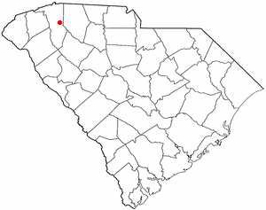
Antreville is a census-designated place (CDP) in Abbeville County, South Carolina, United States. The population was 140 at the 2010 census.

<span class="mw-page-title-main">Centerville, South Carolina</span> Census-designated place in South Carolina, United States

Centerville is a census-designated place (CDP) in Anderson County, South Carolina, United States. The population was 6,586 at the 2010 census.

<span class="mw-page-title-main">Homeland Park, South Carolina</span> Census-designated place in South Carolina, United States

Homeland Park is a census-designated place (CDP) in Anderson County, South Carolina, United States. The population was 6,296 at the 2010 census.

<span class="mw-page-title-main">Northlake, South Carolina</span> Census-designated place in South Carolina, United States

Northlake is a census-designated place (CDP) in Anderson County, South Carolina, United States. The population was 3,745 at the 2010 census.

<span class="mw-page-title-main">Berea, South Carolina</span> CDP in South Carolina, United States

Berea is a census-designated place (CDP) in Greenville County, South Carolina, United States. The population was 14,295 at the 2010 census. It is part of the Greenville–Mauldin–Easley Metropolitan Statistical Area.

<span class="mw-page-title-main">City View, South Carolina</span> Census-designated place in South Carolina, United States

City View, a former incorporated city, is now a census-designated place (CDP) in Greenville County, South Carolina, United States. The population was 1,345 at the 2010 census, up from 1,254 in 2000. It is part of the Greenville–Mauldin–Easley Metropolitan Statistical Area.

Duncan is a census-designated place (CDP) in Greenville County, South Carolina, United States. The population was 3,671 at the 2010 census, down from 4,158 in 2000. It is part of the Greenville–Mauldin–Easley Metropolitan Statistical Area.

<span class="mw-page-title-main">Gantt, South Carolina</span> Census-designated place in South Carolina, United States

Gantt is a census-designated place (CDP) in Greenville County, South Carolina, United States. The population was 14,229 at the 2010 census. It is part of the Greenville–Mauldin–Easley Metropolitan Statistical Area and a suburb of the city of Greenville.

Judson is a census-designated place (CDP) in Greenville County, South Carolina, United States. The population was 2,050 at the 2010 census, down from 2,456 at the 2000 census. It is part of the Greenville–Mauldin–Easley Metropolitan Statistical Area.

Parker is a census-designated place (CDP) in Greenville County, South Carolina, United States. The population was 11,431 at the 2010 census, up from 10,760 in 2000. It is part of the Greenville–Mauldin–Easley Metropolitan Statistical Area.

<span class="mw-page-title-main">Taylors, South Carolina</span> CDP in South Carolina, United States

Taylors is a census-designated place (CDP) in Greenville County, South Carolina, United States. The population was 21,617 at the 2010 census. Taylors is the Greenville/Spartanburg area's largest suburb although it is not incorporated as a city. It is part of the Greenville–Mauldin–Easley Metropolitan Statistical Area. The area serves as the result of urban sprawl in the Greenville metropolitan city.

Wade Hampton is a census-designated place (CDP) in Greenville County, South Carolina, United States. The population was 20,622 at the 2010 census. It is named for American Civil War general and South Carolina governor Wade Hampton.

<span class="mw-page-title-main">Welcome, South Carolina</span> Census-designated place in South Carolina, United States

Welcome is a census-designated place (CDP) in Greenville County, South Carolina, United States. The population was 6,668 at the 2010 census. It is part of the Greenville–Mauldin–Easley Metropolitan Statistical Area. Welcome has been noted for its colorful place name.

<span class="mw-page-title-main">Cokesbury, South Carolina</span> Census-designated place in South Carolina, United States

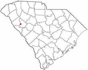
Cokesbury is a census-designated place (CDP) in Greenwood County, South Carolina, United States. The population was 215 at the 2010 census, down from 279 in 2000.

<span class="mw-page-title-main">Promised Land, South Carolina</span> Census-designated place in South Carolina, United States

Promised Land is an unincorporated community and census-designated place (CDP) in Greenwood County, South Carolina, United States. The population was 511 at the 2010 census.

<span class="mw-page-title-main">Mount Carmel, South Carolina</span> CDP in South Carolina, United States

Mt. Carmel is a census-designated place (CDP) in McCormick County, South Carolina, United States. The population was 237 at the 2000 census.

<span class="mw-page-title-main">Startex, South Carolina</span> CDP in South Carolina, United States

Startex is a census-designated place (CDP) in Spartanburg County, South Carolina, United States. The population was 859 at the 2010 census. The area was originally known as Tucapau, named after the mill that was built there in 1896. In 1936, Walter Montgomery Sr. bought the mill and changed its name to Startex—the brand name of household textiles produced at the plant. The mill ceased operations in 1998 and was mostly dismantled in 1999.

<span class="mw-page-title-main">Rib Mountain (CDP), Wisconsin</span> CDP in Wisconsin, United States

Rib Mountain is a census-designated place (CDP) in the town of Rib Mountain in Marathon County, Wisconsin, United States. The population was 6,061 at the 2020 census.

References

  1. "ArcGIS REST Services Directory". United States Census Bureau. Retrieved October 15, 2022.
  2. 1 2 U.S. Geological Survey Geographic Names Information System: Utica, South Carolina
  3. "Census Population API". United States Census Bureau. Retrieved Oct 15, 2022.
  4. "Utica SC ZIP Code". zipdatamaps.com. 2023. Retrieved February 17, 2023.
  5. 1 2 "U.S. Census website". United States Census Bureau . Retrieved 2008-01-31.
  6. "US Gazetteer files: 2010, 2000, and 1990". United States Census Bureau. 2011-02-12. Retrieved 2011-04-23.
  7. "Census of Population and Housing". Census.gov. Retrieved June 4, 2016.

U.S. Geological Survey Geographic Names Information System: Utica, South Carolina