Salem, South Carolina

Last updated
Salem, South Carolina
Salem-welcome-sign-sc.jpg
Welcome sign along (SC 130)
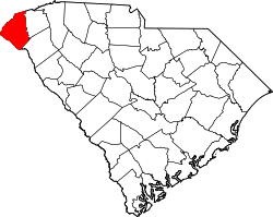
Oconee County South Carolina incorporated and unincorporated areas Salem highlighted.svg
Location in Oconee County and the state of South Carolina.
Coordinates: 34°53′19″N82°58′29″W / 34.88861°N 82.97472°W / 34.88861; -82.97472
Country United States
State South Carolina
County Oconee
Area
[1]
  Total0.92 sq mi (2.37 km2)
  Land0.92 sq mi (2.37 km2)
  Water0.00 sq mi (0.00 km2)
Elevation
[2]
1,063 ft (324 m)
Population
 (2020) [3]
  Total120
  Density131.15/sq mi (50.61/km2)
Time zone UTC-5 (Eastern (EST))
  Summer (DST) UTC-4 (EDT)
ZIP code
29676
Area code 864
FIPS code 45-62980 [4]
GNIS feature ID1230283 [2]
Website www.facebook.com/Salem-Town-Hall-1702501816656220/

Salem is a U.S. town in Oconee County, South Carolina. The population was 135 at the 2010 United States Census. [5]

Contents

Geography

Salem is located at 34°53′19″N82°58′29″W / 34.88861°N 82.97472°W / 34.88861; -82.97472 (34.888599, -82.974666). [6] The town lies in the foothills of the Blue Ridge Mountains along South Carolina Highway 130, just south of its junction with South Carolina Highway 11. Lake Keowee and Keowee-Toxaway State Park lie just to the east, and Lake Jocassee and Devils Fork State Park lie to the northeast. The North Carolina-South Carolina border passes several miles north of Salem.

According to the United States Census Bureau, the town has a total area of 0.8 square miles (2.2 km2), all of it land.

Demographics

Historical population
CensusPop.Note
1910 139
1960 206
1970 30146.1%
1980 194−35.5%
1990 192−1.0%
2000 126−34.4%
2010 1357.1%
2020 120−11.1%
U.S. Decennial Census [7] [3]

At the 2000 census there were 126 people, 54 households, and 36 families in the town. The population density was 150.5 inhabitants per square mile (58.1/km2). There were 72 housing units at an average density of 86.0 per square mile (33.2/km2). The racial makeup of the town was 95.24% White, 0.79% African American and 3.97% Native American. [4] Of the 54 households 31.5% had children under the age of 18 living with them, 59.3% were married couples living together, 7.4% had a female householder with no husband present, and 33.3% were non-families. 31.5% of households were one person and 22.2% were one person aged 65 or older. The average household size was 2.33 and the average family size was 2.94.

The age distribution was 23.8% under the age of 18, 7.9% from 18 to 24, 27.8% from 25 to 44, 18.3% from 45 to 64, and 22.2% 65 or older. The median age was 40 years. For every 100 females, there were 85.3 males. For every 100 females age 18 and over, there were 77.8 males.

The median household income was $30,000 and the median family income was $33,125. Males had a median income of $35,000 versus $26,667 for females. The per capita income for the town was $14,980. There were 9.7% of families and 12.5% of the population living below the poverty line, including 11.1% of under eighteens and 18.8% of those over 64.

Education

Salem has a lending library, a branch of the Oconee County Public Library. [8]

Related Research Articles

<span class="mw-page-title-main">Pickens County, South Carolina</span> County in South Carolina, United States

Pickens County is located in the northwest part of the U.S. state of South Carolina. As of the 2020 census, its population was 131,404. Its county seat is Pickens. The county was created in 1826. It is part of the Greenville-Anderson-Mauldin, SC Metropolitan Statistical Area.

<span class="mw-page-title-main">Oconee County, South Carolina</span> County in South Carolina, United States

Oconee County is the westernmost county in the U.S. state of South Carolina. As of the 2020 census, the population was 78,607. Its county seat is Walhalla and its largest city is Seneca. Oconee County is included in the Seneca, SC Micropolitan Statistical Area, which is also included in the Greenville-Spartanburg-Anderson, SC Combined Statistical Area. South Carolina Highway 11, the Cherokee Foothills National Scenic Highway, begins in southern Oconee County at Interstate Highway 85 at the Georgia state line.

<span class="mw-page-title-main">Oconee, Georgia</span> City in Georgia, United States

Oconee is a city in Washington County, Georgia, United States. The population was 280 at the 2000 census.

<span class="mw-page-title-main">Lewisville, North Carolina</span> Town in North Carolina, United States

Lewisville is a town in Forsyth County, North Carolina, United States of America. The population was 13,388 at the 2020 census, up from 12,639 in 2010. It is a Piedmont Triad community.

<span class="mw-page-title-main">Fremont, North Carolina</span> Town in North Carolina, United States

Fremont is a town in Wayne County, North Carolina, United States. The population was 1,255 at the 2010 census. It is included in the Goldsboro, North Carolina Metropolitan Statistical Area.

<span class="mw-page-title-main">Calhoun Falls, South Carolina</span> Town in South Carolina, United States

Calhoun Falls is a town in Abbeville County, South Carolina, United States. The population was 1,724 at the 2020 census, down from 2,004 at the 2010 census.

<span class="mw-page-title-main">Donalds, South Carolina</span> Town in South Carolina, United States

Donalds is a town in Abbeville County, South Carolina, United States. As per the 2010 United States Census, its population was 348.

<span class="mw-page-title-main">Iva, South Carolina</span> Town in South Carolina, United States

Iva is a town in Anderson County, South Carolina, United States. The population was 1,218 at the 2010 census.

<span class="mw-page-title-main">Great Falls, South Carolina</span> Town in South Carolina, United States

Great Falls is a town in Chester County, South Carolina, United States and is located fourteen miles southwest of Lancaster, South Carolina. The population was 1,951 at the 2020 census.

<span class="mw-page-title-main">Pamplico, South Carolina</span> Town in South Carolina, United States

Pamplico is a town in southeastern Florence County, South Carolina, United States. The population was 1,226 at the 2010 census. It is part of the Florence Metropolitan Statistical Area.

<span class="mw-page-title-main">Hodges, South Carolina</span> Town in South Carolina, United States

Hodges is a town in Greenwood County, South Carolina, United States. The population was 155 at the 2010 census. The mayor is Michael George.

<span class="mw-page-title-main">Plum Branch, South Carolina</span> Town in South Carolina, United States

Plum Branch is a town in McCormick County, South Carolina, United States. The population was 82 at the 2010 census.

<span class="mw-page-title-main">Seneca, South Carolina</span> City in South Carolina, United States

Seneca is a city in Oconee County, South Carolina, United States. The population was 8,102 at the 2010 census. It is the principal city of the Seneca Micropolitan Statistical Area, an (MSA) that includes all of Oconee County, and that is included within the greater Greenville-Spartanburg-Anderson, South Carolina Combined Statistical Area. Seneca was named for the nearby Cherokee town of Isunigu, which English colonists knew as "Seneca Town".

<span class="mw-page-title-main">Utica, South Carolina</span> Census-designated place in South Carolina, United States

Utica is a census-designated place (CDP) in Oconee County, South Carolina, United States. The population was 1,322 at the 2000 census.

<span class="mw-page-title-main">Walhalla, South Carolina</span> City in South Carolina, United States

Walhalla is a city in the foothills of the Blue Ridge Mountains in Oconee County, South Carolina, United States. Designated in 1868 as the county seat, it lies within the area of the Blue Ridge Escarpment, an area of transition between mountains and piedmont, and contains numerous waterfalls. It is located 16 miles (26 km) from Clemson University in Clemson, South Carolina.

<span class="mw-page-title-main">West Union, South Carolina</span> Town in South Carolina, United States

West Union is a town in Oconee County, South Carolina, United States. Although its name suggests that it is near Union, they are approximately four counties apart. The population was 291 at the 2010 census.

Norris is a town in Pickens County, South Carolina, United States. The population was 813 at the 2010 census. It is part of the Greenville–Mauldin–Easley Metropolitan Statistical Area.

<span class="mw-page-title-main">Pickens, South Carolina</span> City in South Carolina, United States

Pickens, formerly called Pickens Courthouse, is a city in Pickens County, South Carolina, United States. The population was 3,126 at the 2010 census. Pickens changed its classification from a town to a city in 1998, but it was not reported to the Census Bureau until 2001. It is the county seat of Pickens County. It was named after Andrew Pickens (1739–1817), an American revolutionary soldier and US Congressman for South Carolina.

Wedgefield is a census-designated place (CDP) in Sumter County, South Carolina, United States. The population was 1,544 at the 2000 census.

Orono is a census-designated place (CDP) consisting of the eastern portion of the town of Orono in Penobscot County, Maine, United States. The population of the CDP was 9,474 at the 2010 census.

References

  1. "ArcGIS REST Services Directory". United States Census Bureau. Retrieved October 15, 2022.
  2. 1 2 U.S. Geological Survey Geographic Names Information System: Salem, South Carolina
  3. 1 2 "Census Population API". United States Census Bureau. Retrieved Oct 15, 2022.
  4. 1 2 "U.S. Census website". United States Census Bureau . Retrieved 2008-01-31.
  5. See http://factfinder.census.gov for population numbers and for municipality and CDP lists in the 2010 Census.
  6. "US Gazetteer files: 2010, 2000, and 1990". United States Census Bureau. 2011-02-12. Retrieved 2011-04-23.
  7. "Census of Population and Housing". Census.gov. Retrieved June 4, 2015.
  8. "South Carolina libraries and archives". SCIWAY. Retrieved 13 June 2019.