High Hills of Santee

Last updated
Historic Church of the Holy Cross, Stateburg, High Hills of the Santee Stateburg holy cross 1419.JPG
Historic Church of the Holy Cross, Stateburg, High Hills of the Santee

The High Hills of Santee, sometimes known as the High Hills of the Santee, is a long, narrow hilly region in the western part of Sumter County, South Carolina. It has been called "one of the state's most famous areas". [1] The High Hills of Santee region lies north of the Santee River and east of the Wateree River, one of the two rivers that join to form the Santee. It extends north almost to the Kershaw county line and northeasterly to include the former summer resort town of Bradford Springs. Since 1902 the town has been included in Lee County.

Contents

The county was named after Thomas Sumter, who came from Virginia, married a local widow in 1767, and with her became a successful plantation owner. He later became noted as a general in the Revolution. After the war, Sumter represented South Carolina in the United States House of Representatives and the Senate.

The High Hills of Santee name has been in use since the 18th century, [2] when the area became a popular resort for wealthy planters. They built summer homes in the region to escape the oppressive "heat and malaria of the Lowcountry" during the summer sick season. [3] In the 18th and 19th centuries, the High Hills of Santee was the location of many cotton plantations, and had a large population of enslaved Africans as laborers. Among the planter families were The Broughtons, The Dinkins, Richardsons, and the Singletons, whose daughter Angelica married Abraham Van Buren eldest son of Martin Van Buren and served as First Lady of the United States after his election as a widower president following the second term of President Andrew Jackson. [4]

The South Carolina historian David Duncan Wallace placed the area in what he called the "red hill region" of the state. He wrote: "The High Hills of Santee paralleling the Wateree River on its east attain an almost mountainous appearance. The region contains much good land." [5]

The area includes three National Historic Landmarks, one National Historic District, and several structures listed on the National Register of Historic Places. It has attractive outdoor recreational areas such as Poinsett State Park and Manchester State Forest.

Despite the short distances to Columbia and Sumter, the High Hills of Santee are relatively rural and isolated, as the area was in antebellum times. [6]

Historic sites

Historic sites in the High Hills of Santee include three National Historic Landmarks:

Other places listed on the National Register of Historic Places include:

Notable residents

Notable plantations and houses

The High Hills of Santee had many notable plantations, most of which grew cotton with slave labor. Some of them survive. [8]

Places

Places, past and present, in the High Hills of Santee, include:

Transportation

River

The Wateree River was one of the first means of access to the High Hills of Santee. Manchester became its gateway river port. There were ferry crossings at Garner's Ferry near Stateburg and further south at Stark's Ferry near Manchester.

Roads

The major north–south road in the High Hills of Santee since the 18th century has been "Kings Highway". It originally ran from Charleston to Camden. It followed an older trail of the Catawba Tribe. Today Kings Highway in the High Hills is South Carolina Highway 261. [18] The major east west road is U.S. Route 76/US Route 378, a four-lane, divided highway between Sumter and Columbia, which intersects South Carolina Highway 261 just south of Stateburg. This intersection is 32 miles from Columbia and 12 miles from Sumter. The original Sumter to Columbia road was "Garner's Ferry Road," a part of which exists north in Stateburg. Most of U.S. Route 76/US Route 378 in Richland County still carries this name.

Millford Plantation was sometimes called Manning's Folly, partly because of its remote location.

Railroads

An antebellum branch of the former South Carolina Railroad ran from Wateree east across the river to Wateree Junction and then north on the west of Kings Highway through Middleton, Foxville, Dixie Crossing, the former Stateburg Station on Garner's Ferry Road, Claremont, Horatio, Hagood and then into Kershaw County. It ran through Boykin before reaching Camden. At Wateree Junction, it met the Wilmington and Manchester Railroad, which ran from Manchester to Wilmington, North Carolina.

In April 1865 General Edward E. Potter and his Union Army troops "discovered nine locomotives and approximately 200 cars from the rolling stock of the Wilmington & Manchester and South Carolina Railroads. His army proceeded to burn, blow up, and otherwise destroy these trains and tracks." During World War II, much of the scrap metal from the wreckage was salvaged for the war effort. In 1997 the remaining rails and cross ties were removed. [19] [20] [21]

From Sumter today one railroad line runs west to Wedgefield and across the Wateree to Eastover. Another runs southwest to Pinewood and across the Upper Santee River" connecting Remini and Low Falls, SC across the Lake Marion now flooded swamp called Sparkleberry to Calhoun County. There is no longer any passenger service on these lines.

Foot trail

The High Hills of Santee Passage is a hiking trail through the area and is part of the Palmetto Trail.

Related Research Articles

<span class="mw-page-title-main">Sumter County, South Carolina</span> County in South Carolina, United States

Sumter County is a county located in the U.S. state of South Carolina. As of the 2020 census, the population was 105,556. Its county seat is Sumter.

<span class="mw-page-title-main">Pinewood, South Carolina</span> Town in South Carolina, United States

Pinewood is a town located on South Carolina Highway 261 at the southern entrance to the High Hills of Santee in Sumter County, South Carolina, United States. The population was 538 at the 2010 census. It is included in the Sumter, South Carolina Metropolitan Statistical Area.

Stateburg is a census-designated place (CDP) in the High Hills of Santee in Sumter County, South Carolina, United States. The population was 1,380 at the 2010 census. It is included in the Sumter, South Carolina Metropolitan Statistical Area. Stateburg is located within the larger Stateburg Historic District.

<span class="mw-page-title-main">Wateree River</span> River in South Carolina, United States

The Wateree River, about 75 mi (120 km) long, is a tributary of the Santee River in central South Carolina in the United States, which flows to the Atlantic Ocean. It was named for the Wateree Native Americans, a tribe who had migrated to this area from western North Carolina. They lived here until the early 18th century, when they were set upon and displaced by mostly English settlers during the Yamasee War. Survivors merged with the larger Catawba people, becoming extinct as a tribe.

<span class="mw-page-title-main">Borough House Plantation</span> Historic house in South Carolina, United States

Borough House Plantation, also known as Borough House, Hillcrest Plantation and Anderson Place, is an historic plantation on South Carolina Highway 261, 0.8 miles (1.3 km) north of its intersection with U.S. Route 76/US Route 378 in Stateburg, in the High Hills of Santee near Sumter, South Carolina. A National Historic Landmark, the plantation is noted as the largest assemblage of high-style pisé structures in the United States. The main house and six buildings on the plantation were built using this technique, beginning in 1821. The plantation is also notable as the home of Confederate Army General Richard H. Anderson.

<span class="mw-page-title-main">Millford Plantation</span> Historic house in South Carolina, United States

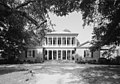
Millford Plantation is a historic farmstead and plantation house located on SC 261 west of Pinewood, South Carolina. It was sometimes called Manning's Folly, because of its remote location in the High Hills of Santee section of the state and its elaborate details. Designated as a National Historic Landmark, it is regarded as one of the finest examples of Greek Revival residential architecture in the United States. The house has been restored and preserved along with many of its original Duncan Phyfe furnishings.

<span class="mw-page-title-main">South Carolina Highway 261</span>

South Carolina Highway 261 (SC 261) is a 116.960-mile (188.229 km) state highway in the U.S. state of South Carolina. It travels between Yauhannah in Georgetown County to Kershaw County. Although the highway covers more east–west distance, it is signed north–south.

<span class="mw-page-title-main">St. Mark's Episcopal Church (Pinewood, South Carolina)</span> Historic church in South Carolina, United States

St. Mark's Episcopal Church is an historic Episcopal church located in the High Hills of Santee west of Pinewood, South Carolina. On January 20, 1978, it was added to the National Register of Historic Places as St. Mark's Church.

<span class="mw-page-title-main">Stateburg Historic District</span> Historic district in South Carolina, United States

The Stateburg Historic District is a historic district in Stateburg, in the High Hills of Santee area near Sumter, South Carolina in the United States. It includes two National Historic Landmarks, Borough House Plantation and the Church of the Holy Cross, and at least eight contributing properties within its boundaries. On February 24, 1971, it was added to the National Register of Historic Places. The historic district extends north and east of the town of Stateburg as far north as Meeting House Road and as far east as South Carolina Highway 441, covering an area of 5,066 acres (20.50 km2).

Singleton's Graveyard is an historic plantation cemetery located off SC 261 in the High Hills of Santee, 6 miles south of Wedgefield, South Carolina. On May 13, 1976, it was added to the National Register of Historic Places.

<span class="mw-page-title-main">Wedgefield, South Carolina</span> Unincorporated community in South Carolina, United States

Wedgefield is an unincorporated community in the High Hills of Santee area in western Sumter County, South Carolina, United States. Wedgefield is also a Census Designated Place (CDP). Wedgefield was so named because its location was likened to a "wedge" into the High Hills of Santee. In the 18th and 19th centuries it was the location of many plantations, notably those of the Singleton family, which produced First Lady of the United States, Angelica Singleton Van Buren. Today the plantations are gone except for their cemeteries and Wedgefield is today noted as the location of a state park, a state forest and other recreational places. When the railroad came through in the 19th century, the commercial center of Wedgefield developed at the intersection of the railroad, Kings Highway and Wedgefield Road. It has its own post office with the Zip Code of 29168.

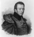
Hagood is an unincorporated community in the High Hills of Santee area in western Sumter County, South Carolina, United States. It lies west of South Carolina Highway 261, north of Stateburg and is the location of Magnolia Hall, which is listed on the National Register of Historic Places. Its mail now comes from Rembert zip code 29128. The community was originally called Sander's Station by the South Carolina Railway, apparently for Dr. Swepson Saunders, the owner of Magnolia Hall plantation, on which it was located, but was renamed Hagood for Johnson Hagood, brigadier general in the Confederate States Army and later governor of South Carolina.

<span class="mw-page-title-main">Magnolia Hall (Hagood, South Carolina)</span> Historic house in South Carolina, United States

Magnolia Hall is an historic plantation located in the High Hills of Santee at 2025 Horatio-Hagood Road, Hagood, South Carolina. Its Greek Revival plantation house was built in 1821 by its owner Isaac Barnes. After Dr. Swepson Saunders bought the property in 1853, he added onto it in 1855 and 1860.

<span class="mw-page-title-main">High Hills of Santee Baptist Church</span> Historic church in South Carolina, United States

High Hills of Santee Baptist Church is an historic Southern Baptist church located in the High Hills of Santee in Stateburg, near Dalzell in Sumter County, South Carolina. Its congregation was founded in 1772 and the present church was built in 1848. Its first pastor was Richard Furman, who went on to become one of South Carolina's most influential ministers. Furman University was named for him. Many of the Baptist churches in the area are offshoots of this church.

<span class="mw-page-title-main">Pinewood Depot</span> United States historic place

Pinewood Depot is an historic railway station located at the junction of East Avenue and Clarke Street in the town of Pinewood, at the southern entrance of the High Hills of Santee, South Carolina. It is the only railroad station left in Sumter County, but is not longer used by CSX, the current owner of the railroad right-of-way. On June 10, 1997, it was added to the National Register of Historic Places.

<span class="mw-page-title-main">Poinsett State Park</span> State park in South Carolina, United States

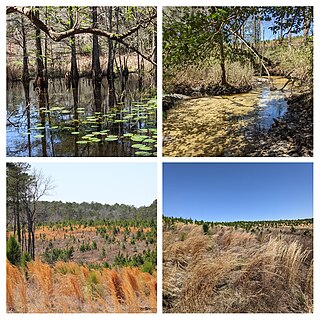
Poinsett State Park is located in Sumter County in the U.S. state of South Carolina. The park is best known for its botanical oddities, combining the flora of the Blue Ridge Mountains foothills and Piedmont of Upstate South Carolina, the xeric Sandhills and the Atlantic coastal plain. In Poinsett State Park one can see mountain laurels draped with Spanish moss. The park, which has been called "weird and beautiful", is named after amateur botanist and South Carolina native Joel Roberts Poinsett, the first American ambassador to Mexico and popularizer of the poinsettia. There is a $3 charge for admission to Poinsett State Park and there are small fees for overnight camping and cabin rentals. The park is surrounded by the Manchester State Forest, and both provide access to the Palmetto Trail, linked hiking and mountain bike trails, and Manchester State Forest offers equestrian trails.

<span class="mw-page-title-main">South Carolina Highway 441</span> Highway in South Carolina, US

South Carolina Highway 441 (SC 441) is a 26.280-mile-long (42.294 km) state highway in the U.S. state of South Carolina. The highway connects the Sumter area in Sumter County with rural areas of Lee County.

<span class="mw-page-title-main">South Carolina Highway 763</span>

South Carolina Highway 763 (SC 763) is a 13.950-mile-long (22.450 km) state highway in the U.S. state of South Carolina. The highway connects Wedgefield and Sumter, via Cane Savannah and Millwood. It is signed north-south, but it travels east-west.

<span class="mw-page-title-main">Manchester State Forest</span> State forest in South Carolina, United States

Manchester State Forest is a State Forest in Clarendon County, South Carolina and Sumter County, South Carolina. Founded in 1949, the forest is named after the former site of Manchester, South Carolina, a once bustling town in the early 19th century.

References

  1. Mary Schuette, Nomination Form for Stateburg Historic District, South Carolina Department of Archives and History
  2. USC Institute for Southern Studies XV 29 [ permanent dead link ]
  3. Richardson, Katherine H., nomination form for St. Philip's, South Carolina Department of Archives and History
  4. "Singleton's Graveyard", South Carolina Department of Archives and History
  5. Wallace, David Duncan, South Carolina: A Short History, 1520-1948, Columbia: University of South Carolina Press, reprinted 1961, p.4
  6. Account of a recent visit to the High Hills of Santee, Random Connections
  7. Historic American Buildings Survey for High Hills of Santee Baptist Church
  8. South Carolina Plantations - Sumter County
  9. Historic American Buildings Survey for Brookland Plantation House
  10. Historic American Buildings Survey
  11. Historic American Buildings Survey done in 1940 [ permanent dead link ]
  12. Names in South Carolina, Winter, 1967, vol, 14, p. 24 [ permanent dead link ]
  13. Historic American Buildings Survey for Needwood
  14. Historic American Buildings Survey for The Oaks
  15. Historic American Buildings Survey for Ramsey House
  16. Names in South Carolina, November, 1966, vol. 13, p.34
  17. Names in South Carolina, Winter, 1973, vol. 20, p.5
  18. Names in the Old Sumter District
  19. Teal, Harvey S. "Experiencing history: a visit to a railroad 'stonehenge'", University of South Caroliniana Society, Newsletter, Spring 1997
  20. Haile, Dr. E. Cantey, Jr., "Civil War History in the Wateree Swamp", University South Caroliniana Society, Newsletter, Spring 1998
  21. "Wateree to Kings Creek", Abandoned Railroads

33°59′02″N80°32′53″W / 33.984°N 80.548°W / 33.984; -80.548