Red Hill, South Carolina

Last updated

Red Hill, South Carolina
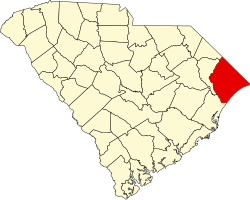
SCMap-doton-RedHill.PNG
Location in South Carolina
Coordinates: 33°47′18″N79°0′49″W / 33.78833°N 79.01361°W / 33.78833; -79.01361
CountryUnited States
State South Carolina
County Horry
Area
[1]
  Total
11.09 sq mi (28.72 km2)
  Land11.01 sq mi (28.52 km2)
  Water0.08 sq mi (0.20 km2)
Elevation
33 ft (10 m)
Population
 (2020) [2]
  Total
15,906
  Density1,444.69/sq mi (557.81/km2)
Time zone UTC−5 (EST)
  Summer (DST) UTC−4 (EDT)
ZIP codes
29020, 29021
FIPS code 45-59190 [3]
GNIS feature ID1225782 [4]

Red Hill is a census-designated place (CDP) in Horry County, South Carolina, United States. The population was 13,223 at the 2010 census, [5] up from 10,509 at the 2000 census.

Contents

Geography

Red Hill is in south-central Horry County at 33°47′18″N79°0′49″W / 33.78833°N 79.01361°W / 33.78833; -79.01361 (33.788368, -79.013715). [6] It is bordered to the north by the city of Conway, the county seat, and to the south by Socastee. U.S. Route 501 passes through the northern part of Red Hill, connecting Conway to the north with Myrtle Beach, 12 miles (19 km) to the southeast. South Carolina Highway 544 runs north–south the length of Red Hill, connecting Conway with Socastee. The west side of Red Hill is bordered by the Waccamaw National Wildlife Refuge.

According to the United States Census Bureau, the CDP has a total area of 11.4 square miles (29.4 km2), of which 11.3 square miles (29.2 km2) are land and 0.1 square miles (0.2 km2), or 0.52%, are water. [5]

Demographics

Historical population
CensusPop.Note
2000 10,509
2010 13,22325.8%
2020 15,90620.3%
U.S. Decennial Census [7]

2020 census

Red Hill racial composition [8]
RaceNum.Perc.
White (non-Hispanic)11,30871.09%
Black or African American (non-Hispanic)1,75311.02%
Native American 600.38%
Asian 2501.57%
Pacific Islander 80.05%
Other/Mixed 7784.89%
Hispanic or Latino 1,74911.0%

As of the 2020 United States census, there were 15,906 people, 5,935 households, and 3,980 families residing in the CDP.

2000 census

At the 2000 census there were 10,509 people, 4,189 households, and 3,066 families living in the CDP. The population density was 961.4 inhabitants per square mile (371.2/km2). There were 5,026 housing units at an average density of 459.8 per square mile (177.5/km2). The racial makeup of the CDP was 88.70% White, 7.34% African American, 0.59% Native American, 0.78% Asian, 0.08% Pacific Islander, 1.22% from other races, and 1.30% from two or more races. Hispanic or Latino of any race were 3.11%. [3]

Of the 4,189 households 31.3% had children under the age of 18 living with them, 58.1% were married couples living together, 11.4% had a female householder with no husband present, and 26.8% were non-families. 19.4% of households were one person and 6.4% were one person aged 65 or older. The average household size was 2.50 and the average family size was 2.83.

The age distribution was 23.5% under the age of 18, 9.2% from 18 to 24, 29.3% from 25 to 44, 23.1% from 45 to 64, and 14.7% 65 or older. The median age was 37 years. For every 100 females, there were 94.8 males. For every 100 females age 18 and over, there were 92.5 males.

The median household income was $37,736 and the median family income was $44,085. Males had a median income of $30,123 versus $21,750 for females. The per capita income for the CDP was $20,036. About 8.2% of families and 12.0% of the population were below the poverty line, including 14.5% of those under age 18 and 6.9% of those age 65 or over.

Related Research Articles

<span class="mw-page-title-main">Horry County, South Carolina</span> County in South Carolina, United States

Horry County is the easternmost county in the U.S. state of South Carolina. As of the 2020 census, its population was 351,029. It is the fourth-most populous county in South Carolina. The county seat is Conway.

<span class="mw-page-title-main">Brickerville, Pennsylvania</span> Census-designated place in Pennsylvania, United States

Brickerville is an unincorporated community and census-designated place (CDP) in Elizabeth Township, Lancaster County, Pennsylvania, United States, with a ZIP code of 17543. The population was 1,309 at the 2010 census.

<span class="mw-page-title-main">Long Hill, Groton, Connecticut</span> Census-designated place in Connecticut, United States

Long Hill is a census-designated place (CDP) in the town of Groton in New London County, Connecticut, United States. The population was 4,205 at the 2010 census.

<span class="mw-page-title-main">Windsor, Indian River County, Florida</span> Census-designated place in Florida, United States

Windsor, formerly known as North Beach, is a gated community and census-designated place (CDP) on North Hutchinson Island in Indian River County, Florida, United States. The population was 256 at the 2010 census. It is part of the Sebastian–Vero Beach Metropolitan Statistical Area.

<span class="mw-page-title-main">Orchard Hills, Pennsylvania</span> Census-designated place in Pennsylvania, United States

Orchard Hills is a census-designated place (CDP) in Armstrong County, Pennsylvania, United States. The population was 1,949 at the 2020 census.

<span class="mw-page-title-main">West Hills, Pennsylvania</span> Census-designated place in Pennsylvania, United States

West Hills is a census-designated place (CDP) in Armstrong County, Pennsylvania, United States. The population was 1,228 at the 2020 census.

<span class="mw-page-title-main">Meadowood, Pennsylvania</span> Census-designated place in Pennsylvania, United States

Meadowood is a census-designated place (CDP) in Butler County, Pennsylvania, United States. The population was 2,693 at the 2010 census.

<span class="mw-page-title-main">Oak Hills, Pennsylvania</span> Census-designated place in Pennsylvania, United States

Oak Hills is a census-designated place (CDP) in Butler County, Pennsylvania, United States. The population was 2,333 at the 2010 census.

<span class="mw-page-title-main">Hiller, Pennsylvania</span> Census-designated place in Pennsylvania, United States

Hiller is an unincorporated community and census-designated place in Fayette County, Pennsylvania, United States. As of the 2010 census, it had a population of 1,155, down from 1,234 at the 2000 census.

<span class="mw-page-title-main">Bucksport, South Carolina</span> Census-designated place in South Carolina, United States

Bucksport is an unincorporated community and census-designated place (CDP) in Horry County, South Carolina, United States. The population was 876 at the 2010 census. It is a rural port on the Atlantic Intracoastal Waterway at the merger point with the Waccamaw River. The port has some services available for boaters and is also home to the Bucksport Restaurant.

<span class="mw-page-title-main">Forestbrook, South Carolina</span> Census-designated place in South Carolina, United States

Forestbrook is a census-designated place (CDP) in Horry County, South Carolina, United States. The population was 4,612 at the 2010 census, up from 3,391 at the 2000 census.

<span class="mw-page-title-main">Garden City, South Carolina</span> CDP in South Carolina, United States

Garden City, sometimes known as Garden City Beach, is a census-designated place (CDP) in Horry County, South Carolina, United States. The population was 9,209 at the 2010 census. Garden City Beach is located directly south of Surfside Beach. The developed part of the beach extends south beyond the limits of the Garden City CDP, into Georgetown County, and ends on a peninsula at the mouth of Murrells Inlet.

<span class="mw-page-title-main">Little River, South Carolina</span> CDP in South Carolina, United States

Little River is a census-designated place (CDP) in Horry County, South Carolina, United States. The population was 11,711 at the 2020 census.

<span class="mw-page-title-main">North Myrtle Beach, South Carolina</span> City in South Carolina, United States

North Myrtle Beach is a city in Horry County, South Carolina, United States. It was created in 1968 from four existing municipalities, and is located about 15 miles (24 km) northeast of Myrtle Beach. It serves as one of the primary tourist destinations along the Grand Strand.

<span class="mw-page-title-main">Socastee, South Carolina</span> CDP in South Carolina, United States

Socastee is a census-designated place (CDP) in Horry County, South Carolina, United States. The population was 19,952 at the 2010 census.

<span class="mw-page-title-main">Colonial Pine Hills, South Dakota</span> CDP in South Dakota, United States

Colonial Pine Hills is a census-designated place (CDP) and unincorporated community in Pennington County, South Dakota, United States. The population was 1,903 at the 2020 census.

<span class="mw-page-title-main">West Springfield, Virginia</span> Census-designated place in Virginia, United States

West Springfield is a census-designated place (CDP) in Fairfax County, Virginia, United States. The population was 23,369 at the 2020 census.

Rafter J Ranch is a census-designated place (CDP) in Teton County, Wyoming, United States. The population was 1,075 at the 2010 census. It is part of the Jackson, WY–ID Micropolitan Statistical Area.

<span class="mw-page-title-main">Lake Wisconsin, Wisconsin</span> CDP in Wisconsin, United States

Lake Wisconsin is a census-designated place (CDP) in Columbia and Sauk counties, in the towns of Lodi and Merrimac, in Wisconsin, United States. The population was 4,616 at the 2020 census, up from 4,189 at the 2010 census.

<span class="mw-page-title-main">Conway (CDP), New Hampshire</span> Census-designated place in New Hampshire, United States

Conway is a census-designated place (CDP) and the primary village in the town of Conway in Carroll County, New Hampshire, United States. The population was 3,576 at the 2020 census. It is the most populous community in the town of Conway, ahead of North Conway.

References

  1. "ArcGIS REST Services Directory". United States Census Bureau. Retrieved October 15, 2022.
  2. "Census Population API". United States Census Bureau. Retrieved October 15, 2022.
  3. 1 2 "U.S. Census website". United States Census Bureau . Retrieved January 31, 2008.
  4. "US Board on Geographic Names". United States Geological Survey. October 25, 2007. Retrieved January 31, 2008.
  5. 1 2 "Geographic Identifiers: 2010 Census Summary File 1 (G001): Red Hill CDP, South Carolina". American Factfinder. U.S. Census Bureau. Archived from the original on February 13, 2020. Retrieved January 26, 2018.
  6. "US Gazetteer files: 2010, 2000, and 1990". United States Census Bureau. February 12, 2011. Retrieved April 23, 2011.
  7. "Census of Population and Housing". Census.gov. Retrieved June 4, 2016.
  8. "Explore Census Data". data.census.gov. Retrieved December 15, 2021.