Homewood, South Carolina | |
|---|---|
 | |
| Country | United States |
| State | South Carolina |
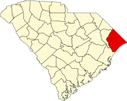
| County | Horry |
| Area | |
• Total | 2.07 sq mi (5.36 km2) |
| • Land | 2.03 sq mi (5.26 km2) |
| • Water | 0.039 sq mi (0.10 km2) |
| Elevation | 26 ft (7.9 m) |
| Population | |
• Total | 1,693 |
| • Density | 833.8/sq mi (321.95/km2) |
| Time zone | UTC-5 (Eastern (EST)) |
| • Summer (DST) | UTC-4 (EDT) |
| ZIP Code | 29526 (Conway) |
| Area code | 843 |
| FIPS code | 45-34765 |
| GNIS feature ID | 2812963 [2] |
Homewood is an unincorporated community and census-designated place (CDP) in Horry County, South Carolina, United States, just north of Conway in the northeastern part of the state. It was first listed as a CDP in the 2020 census with a population of 1,693. [4] [5]
Contents
Homewood is located at the junction of South Carolina Highway 319 and U.S. Highway 701. There is an elementary school in the community. Many of the inhabitants make a living from family farms, growing tobacco, corn, soybeans, and tomatoes.