Finklea, South Carolina | |
|---|---|
 Finklea  Finklea | |
| Coordinates: 34°06′06″N78°59′41″W / 34.10167°N 78.99472°W [1] | |
| Country | United States |
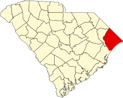
| State | South Carolina |
| County | Horry |
| Area | |
• Total | 2.69 sq mi (6.98 km2) |
| • Land | 2.69 sq mi (6.98 km2) |
| • Water | 0 sq mi (0.00 km2) |
| Elevation | 79 ft (24 m) |
| Population | |
• Total | 291 |
| • Density | 108/sq mi (41.7/km2) |
| Time zone | UTC-5 (Eastern (EST)) |
| • Summer (DST) | UTC-4 (EDT) |
| ZIP Code | 29569 (Loris) |
| Area codes | 843/854 |
| FIPS code | 45-25405 |
| GNIS feature ID | 2812962 [1] |
Finklea is an unincorporated community and census-designated place (CDP) in Horry County, South Carolina, United States. As of the 2020 census it had a population of 291. [4] [5]
Contents
The CDP is in northern Horry County, at the intersection of South Carolina Highways 410, 917 and 9 Business. Highway 410 leads south 9 miles (14 km) to U.S. Route 701 at Baxter Forks and northeast 8 miles (13 km) to Tabor City, North Carolina, and Highway 917 leads northwest 19 miles (31 km) to Mullins. The Highway 9 business loop leads north with Highway 410 1 mile (1.6 km) to Highway 9 at Green Sea and southeast 6 miles (10 km) to Loris.