Aynor, South Carolina

Last updated

Aynor, South Carolina
Aynor, SC Town Seal.png
Nickname: 
The Little Golden Town [1]
SCMap-doton-Aynor.PNG
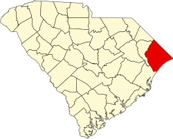
Location in South Carolina
Coordinates: 33°59′52″N79°12′9″W / 33.99778°N 79.20250°W / 33.99778; -79.20250
Country United States
State South Carolina
County Horry
Government
   Mayor John Gardner
Area
[2]
  Total1.80 sq mi (4.67 km2)
  Land1.80 sq mi (4.67 km2)
  Water0.00 sq mi (0.00 km2)
Elevation
102 ft (31 m)
Population
 (2020) [3]
  Total974
  Density540.51/sq mi (208.73/km2)
Demonym Aynorite
Time zone UTC-5 (EST)
  Summer (DST) UTC-4 (EDT)
ZIP codes
29511, 29544
Area codes 843, 854
FIPS code 45-03430 [4]
GNIS feature ID1220269 [5]
Website www.townofaynor.net

Aynor is a small town in Horry County, South Carolina, United States, south of Galivants Ferry. The population was 560 at the 2010 census [6] and estimated in 2018 to be 934. [7] Aynor High School consistently ranks as one of the best schools in Horry County and South Carolina. [8]

Contents

Geography

Aynor is in northwestern Horry County, along U.S. Route 501, which leads 15 miles (24 km) southeast to Conway, the county seat, and northwest 18 miles (29 km) to Marion. Myrtle Beach is 29 miles (47 km) to the southeast of Aynor via US 501.

According to the United States Census Bureau, the town has a total area of 1.9 square miles (4.8 km2), all land. [6]

History

Aynor was settled as the Eyknor's Farm in the mid-19th century under Jacob Eyknor. [9] After a railway terminus was added along the railroad from Conway, the town was incorporated in 1913. It elected a mayor and town wardens (now town council members). Gabriel Edwards (1849–1938) was elected the first mayor in 1913 and again in 1923 for a non-consecutive second term. The town developed as a center for production of turpentine, tobacco, and cotton as commodity crops. [9]

Demographics

Historical population
CensusPop.Note
1920 275
1930 37536.4%
1940 53743.2%
1950 5512.6%
1960 63515.2%
1970 536−15.6%
1980 64320.0%
1990 470−26.9%
2000 58724.9%
2010 560−4.6%
2020 97473.9%
U.S. Decennial Census [3]

2020 census

Aynor racial composition [10]
RaceNum.Perc.
White (non-Hispanic)83986.14%
Black or African American (non-Hispanic)646.57%
Native American 70.72%
Asian 50.51%
Other/Mixed 313.18%
Hispanic or Latino 282.87%

As of the 2020 United States census, there were 974 people, 298 households, and 232 families residing in the town.

2010 census

As of the census [4] of 2010, there were 560 people, 228 households, and 158 families residing in the town. The population density was 533.3 inhabitants per square mile (205.9/km2). There were 257 housing units at an average density of 233.5 per square mile (90.2/km2). The racial makeup of the town was 86.20% White, 11.75% African American, 0.51% Native American, 1.19% from other races, and 0.34% from two or more races. Hispanic or Latino of any race were 1.53% of the population.

There were 228 households, out of which 30.3% had children under the age of 18 living with them, 50.0% were married couples living together, 14.9% had a female householder with no husband present, and 30.7% were non-families. 28.5% of all households were made up of individuals, and 14.5% had someone living alone who was 65 years of age or older. The average household size was 2.57 and the average family size was 3.12.

In the town, the population was spread out, with 26.7% under the age of 18, 8.9% from 18 to 24, 28.8% from 25 to 44, 20.3% from 45 to 64, and 15.3% who were 65 years of age or older. The median age was 36 years. For every 100 females, there were 86.3 males. For every 100 females age 18 and over, there were 77.7 males.

The median income for a household in the town was $29,583, and the median income for a family was $35,417. Males had a median income of $30,781 versus $22,500 for females. The per capita income for the town was $16,076. About 13.1% of families and 19.6% of the population were below the poverty line, including 25.3% of those under age 18 and 15.4% of those age 65 or over.

Government

The town is run by a Mayor-council government system. John Gardner is the current mayor of Aynor.

Aynor is also home to the tribal office of the Waccamaw people. [11]

Economy

In 2013, PTR Industries [12] relocated to the Cool Springs Business Park [13] near Aynor from Bristol, Connecticut after that state passed restrictive gun control legislation. The company said that it will hire an additional 30 workers within the first quarter of 2014, with a goal of having 120 employees in 2017. [14]

Education

Public education in Aynor is administered by Horry County Schools. The district operates Aynor High School.

Aynor has a public library, a branch of the Horry County Memorial Library. [15]

Related Research Articles

<span class="mw-page-title-main">Marion County, South Carolina</span> County in South Carolina, United States

Marion County is a county located in the coastal plain of the U.S. state of South Carolina. As of the 2020 census, its population was 29,183. Its county seat is Marion. It is a majority-minority county.

<span class="mw-page-title-main">Horry County, South Carolina</span> County in South Carolina, United States

Horry County is the easternmost county in the U.S. state of South Carolina. As of the 2020 census, its population was 351,029. It is the fourth-most populous county in South Carolina. The county seat is Conway.

<span class="mw-page-title-main">Georgetown County, South Carolina</span> County in South Carolina, United States

Georgetown County is a county located in the U.S. state of South Carolina. As of the 2020 census, the population was 63,404. Its county seat is Georgetown. The county was founded in 1769. It is named for George III of the United Kingdom.

<span class="mw-page-title-main">Whiteville, North Carolina</span> City in North Carolina, United States

Whiteville is a city in Columbus County, North Carolina, United States. The population was 5,394 at the 2010 census. It is the most populous city in Columbus County and is the county seat.

<span class="mw-page-title-main">Summerton, South Carolina</span> Town in South Carolina, United States

Summerton is a town in Clarendon County, South Carolina, United States. Per the 2020 census, the population was 814.

<span class="mw-page-title-main">Murrells Inlet, South Carolina</span> Census-designated place in South Carolina, United States

Murrells Inlet is an unincorporated area and census-designated place in Georgetown County, South Carolina, United States. The population was 7,547 at the 2010 census. It is about 13 miles south of Myrtle Beach, South Carolina and 21 miles north of Georgetown, the county seat.

<span class="mw-page-title-main">Pawleys Island, South Carolina</span> Town in South Carolina, United States

Pawleys Island is a town in Georgetown County, South Carolina, United States, and the Atlantic coast barrier island on which the town is located.

Varnville is a town in Hampton County, South Carolina, United States. The population was 2,162 as of the 2010 census. Varnville forms a twin town with Hampton, the county seat; the two towns often share civic and cultural events.

<span class="mw-page-title-main">Briarcliffe Acres, South Carolina</span> Town in South Carolina, United States

Briarcliffe Acres is a town in Horry County, South Carolina, United States, located between Myrtle Beach and North Myrtle Beach. The population was 457 at the 2010 census.

<span class="mw-page-title-main">Bucksport, South Carolina</span> Census-designated place in South Carolina, United States

Bucksport is an unincorporated community and census-designated place (CDP) in Horry County, South Carolina, United States. The population was 876 at the 2010 census. It is a rural port on the Atlantic Intracoastal Waterway at the merger point with the Waccamaw River. The port has some services available for boaters and is also home to the Bucksport Restaurant.

<span class="mw-page-title-main">Conway, South Carolina</span> City in South Carolina, United States

Conway is a city and the county seat of Horry County, South Carolina, United States. The population was 24,849 at the 2020 census, up from 17,103 in the 2010 census, making it the 18th-most populous city in the state. The city is part of the Myrtle Beach metropolitan area. It is the home of Coastal Carolina University.

<span class="mw-page-title-main">Forestbrook, South Carolina</span> Census-designated place in South Carolina, United States

Forestbrook is a census-designated place (CDP) in Horry County, South Carolina, United States. The population was 4,612 at the 2010 census, up from 3,391 at the 2000 census.

<span class="mw-page-title-main">Garden City, South Carolina</span> CDP in South Carolina, United States

Garden City, sometimes known as Garden City Beach, is a census-designated place (CDP) in Horry County, South Carolina, United States. The population was 9,209 at the 2010 census. Garden City Beach is located directly south of Surfside Beach. The developed part of the beach extends south beyond the limits of the Garden City CDP, into Georgetown County, and ends on a peninsula at the mouth of Murrells Inlet.

<span class="mw-page-title-main">Little River, South Carolina</span> CDP in South Carolina, United States

Little River is a census-designated place (CDP) in Horry County, South Carolina, United States. The population was 11,711 at the 2020 census.

<span class="mw-page-title-main">Loris, South Carolina</span> City in South Carolina, United States

Loris is a city in Horry County, South Carolina, United States. The population was 2,396 at the 2010 census, up from 2,079 in 2000.

<span class="mw-page-title-main">North Myrtle Beach, South Carolina</span> City in South Carolina, United States

North Myrtle Beach is a city in Horry County, South Carolina, United States. It was created in 1968 from four existing municipalities, and is located about 15 miles (24 km) northeast of Myrtle Beach. It serves as one of the primary tourist destinations along the Grand Strand.

<span class="mw-page-title-main">Red Hill, South Carolina</span> Census-designated place in South Carolina, United States

Red Hill is a census-designated place (CDP) in Horry County, South Carolina, United States. The population was 13,223 at the 2010 census, up from 10,509 at the 2000 census.

<span class="mw-page-title-main">Socastee, South Carolina</span> CDP in South Carolina, United States

Socastee is a census-designated place (CDP) in Horry County, South Carolina, United States. The population was 19,952 at the 2010 census.

<span class="mw-page-title-main">Surfside Beach, South Carolina</span> Town in South Carolina, United States

Surfside Beach is a town in Horry County, South Carolina, United States. Its nickname is "The Family Beach". The population was 3,837 at the 2010 census, down from 4,425 in 2000. It is considered a part of the Grand Strand.

<span class="mw-page-title-main">Hemingway, South Carolina</span> Town in South Carolina, United States

Hemingway is a town in Williamsburg County, South Carolina, United States. The population was 459 at the 2010 census.

References

  1. "Welcome to Aynor". Town of Aynor, South Carolina. Retrieved January 25, 2018.
  2. "ArcGIS REST Services Directory". United States Census Bureau. Retrieved October 15, 2022.
  3. 1 2 "Census Population API". United States Census Bureau. Retrieved October 15, 2022.
  4. 1 2 "U.S. Census website". United States Census Bureau . Retrieved January 31, 2008.
  5. "US Board on Geographic Names". United States Geological Survey. October 25, 2007. Retrieved January 31, 2008.
  6. 1 2 "Geographic Identifiers: 2010 Census Summary File 1 (G001): Aynor town, South Carolina". American Factfinder. U.S. Census Bureau. Archived from the original on February 13, 2020. Retrieved January 25, 2018.
  7. "Population and Housing Unit Estimates" . Retrieved March 14, 2020.
  8. "Best High Schools South Carolina". U.S. News.
  9. 1 2 "History of Aynor". Town of Aynor. Retrieved May 27, 2013.
  10. "Explore Census Data". data.census.gov. Retrieved December 15, 2021.
  11. "Updates". Welcome - Waccamaw Indians. 2018. Retrieved July 17, 2018.
  12. "PTR Industries". Archived from the original on January 8, 2014. Retrieved January 8, 2014.
  13. Cool Springs Business Park Archived January 8, 2014, at the Wayback Machine
  14. Miller, Joshua (January 7, 2014). "Locked & loaded: Gun maker finds warmer surroundings in South Carolina after leaving Connecticut". Fox News. Retrieved January 7, 2014.
  15. "Locations & Hours". Greenville County Library System. Retrieved June 8, 2019.