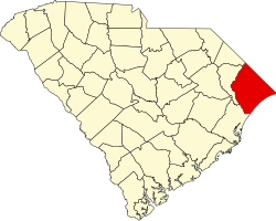
Bucksville, South Carolina

Last updated

Bucksville, South Carolina
Country United States
State South Carolina
County Horry
Time zone Eastern
ZIP Code
29527
Area code 843

Bucksville is a small unincorporated community in Horry County, South Carolina, United States. [1] It lies near Bucksport on the Pee Dee River and Waccamaw River. Two properties are listed on the National Register of Historic Places: the Buck's Upper Mill Farm and Hebron Church. [2]

History

Henry Buck of Bucksport, Maine moved to South Carolina in the 1820s to start lumber mills; Horry County had a significant timber industry with its cypress, pine and hardwood forests. One of Buck's mills was in what became Bucksport. Sawmills in Bucksport and Bucksville produced 3 million board feet of lumber annually by 1850. Buck used his ships to transport lumber to Georgetown and Charleston in South Carolina and as far away as New York City and Boston, and even to other countries. Lumber from Buck's operation even went into the construction of the Brooklyn Bridge. The Independent Republic Quarterly said, "By 1860, due largely to Bucksville and Bucksport, Horry District had become one of the five greatest timber-producing districts in the state." [3] Buck also was one of the largest slave owners in Horry County, with a plantation of 20,000 acres in the Bucksville community. The house, built in 1828, was restored in 1984 by Buck family members who continue to live there in 2011. The slave cemetery is still in use. [3]

Related Research Articles

<span class="mw-page-title-main">Horry County, South Carolina</span> County in South Carolina, United States

Horry County is the easternmost county in the U.S. state of South Carolina. As of the 2020 census, its population was 351,029. It is the fourth-most populous county in South Carolina. The county seat is Conway.

<span class="mw-page-title-main">Georgetown County, South Carolina</span> County in South Carolina, United States

Georgetown County is a county located in the U.S. state of South Carolina. As of the 2020 census, the population was 63,404. Its county seat is Georgetown. The county was founded in 1769. It is named for George III of the United Kingdom.

<span class="mw-page-title-main">Dillon County, South Carolina</span> County in South Carolina, United States

Dillon County is a county located in the U.S. state of South Carolina. As of the 2020 census, the county's population was 28,292. The county seat is Dillon.

<span class="mw-page-title-main">Laurel, Mississippi</span> City in Mississippi, United States

Laurel is a city in and the second county seat of Jones County, Mississippi, United States. As of the 2020 census, the city had a population of 17,161. Laurel is northeast of Ellisville, the first county seat, which contains the first county courthouse. It has the second county courthouse, as Jones County has two judicial districts. Laurel is the headquarters of the Jones County Sheriff's Department, which administers in the county. Laurel is the principal city of a micropolitan statistical area named for it. Major employers include Howard Industries, Sanderson Farms, Masonite International, Family Health Center, Howse Implement, Thermo-Kool, and South Central Regional Medical Center. Laurel is home to the Lauren Rogers Museum of Art, Mississippi's oldest art museum, established by the family of Lauren Eastman Rogers.

<span class="mw-page-title-main">Aberdeen, North Carolina</span> Town in North Carolina, United States

Aberdeen is a town in Moore County, North Carolina, United States. The population was 6,350 at the 2010 census.

<span class="mw-page-title-main">Georgetown, South Carolina</span> City in South Carolina, United States

Georgetown is the third oldest city in the U.S. state of South Carolina and the county seat of Georgetown County, in the Lowcountry. As of the 2010 census it had a population of 9,163. Located on Winyah Bay at the confluence of the Black, Great Pee Dee, Waccamaw, and Sampit rivers, Georgetown is the second largest seaport in South Carolina, handling over 960,000 tons of materials a year, while Charleston is the largest.

<span class="mw-page-title-main">Bucksport, South Carolina</span> Census-designated place in South Carolina, United States

Bucksport is an unincorporated community and census-designated place (CDP) in Horry County, South Carolina, United States. The population was 876 at the 2010 census. It is a rural port on the Atlantic Intracoastal Waterway at the merger point with the Waccamaw River. The port has some services available for boaters and is also home to the Bucksport Restaurant.

<span class="mw-page-title-main">Socastee, South Carolina</span> CDP in South Carolina, United States

Socastee is a census-designated place (CDP) in Horry County, South Carolina, United States. The population was 19,952 at the 2010 census.

<span class="mw-page-title-main">Sawmill</span> Facility where logs are cut into lumber

A sawmill or lumber mill is a facility where logs are cut into lumber. Modern sawmills use a motorized saw to cut logs lengthwise to make long pieces, and crosswise to length depending on standard or custom sizes. The "portable" sawmill is simple to operate. The log lies flat on a steel bed, and the motorized saw cuts the log horizontally along the length of the bed, by the operator manually pushing the saw. The most basic kind of sawmill consists of a chainsaw and a customized jig, with similar horizontal operation.

<span class="mw-page-title-main">Waccamaw River</span> River in the United States of America

The Waccamaw River is a river, approximately 140 miles (225 km) long, in southeastern North Carolina and eastern South Carolina in the United States. It drains an area of approximately 1,110 square miles (2886 km²) in the coastal plain along the eastern border between the two states into the Atlantic Ocean. Along its upper course, it is a slow-moving, blackwater river surrounded by vast wetlands, passable only by shallow-draft watercraft such as canoe. Along its lower course, it is lined by sandy banks and old plantation houses, providing an important navigation channel with a unique geography, flowing roughly parallel to the coast.

<span class="mw-page-title-main">Lumber River</span> River in North Carolina, United States

The Lumber River, sometimes referred to as the Lumbee River, is a 133-mile-long (214 km) river in south-central North Carolina in the flat Coastal Plain. European settlers first called the river Drowning Creek, which is still used as the name of its headwater. The waterway known as the Lumber River extends downstream from the Scotland County-Hoke County border to the North Carolina-South Carolina border. Soon after crossing into South Carolina, the Lumber River flows into the Little Pee Dee River, which flows into the Pee Dee River, or Great Pee Dee River. Finally, the combined waters flow into Winyah Bay and the Atlantic Ocean.

<span class="mw-page-title-main">Galivants Ferry, South Carolina</span> Unincorporated Community in South Carolina, United States

Galivants Ferry is an unincorporated community in Horry County, South Carolina, United States. It lies on the Little Pee Dee River west of Aynor on U.S. Route 501.

<span class="mw-page-title-main">Peter Horry</span> American politician

Peter Horry was an American planter who served as an officer in the southern theater of the American Revolutionary War. He served under the command of Francis Marion, waging a guerilla war against the British and Loyalist forces. Peter Horry was elected to public office, served in the state militia, and oversaw a controversial history of Marion.

<span class="mw-page-title-main">Bucksport, California</span> Unincorporated community in California, United States

Bucksport was a town in Humboldt County, California. The original location was 2.5 miles (4 km) southwest of downtown Eureka, on Humboldt Bay about 5 miles (8 km) northeast of entrance. at an elevation of 16 feet (4.9 m). Prior to American settlement a Wiyot village named Kucuwalik stood here.

<span class="mw-page-title-main">Harrietta Plantation</span> Historic house in South Carolina, United States

Harrieta Plantation is a plantation about 5 mi (8 km) east of McClellanville in Charleston County, South Carolina. It is located off US Highway 17 near the Santee River, adjacent to the Wedge Plantation and just south of Fairfield Plantation. The plantation house was built around 1807 and was named to the National Register of Historic Places on September 18, 1975.

<span class="mw-page-title-main">Hebron Church (Bucksville, South Carolina)</span> Historic church in South Carolina, United States

Hebron Church, also known as Hebron Methodist Church, is a historic Methodist church located at Bucksville in Horry County, South Carolina. The sanctuary was built about 1855 and is a rectangular "meeting house form" one-story frame church with batten siding and a gable roof covered with tin. It features a slightly lower, pedimented, projecting portico supported by five square, wooden columns. Also on the property are two graveyards: the church graveyard and the Henry Buck family graveyard located across the road.

<span class="mw-page-title-main">Buck's Upper Mill Farm</span> Historic house in South Carolina, United States

Buck's Upper Mill Farm, also known as Henry Buck House, is a historic home located at Bucksville in Horry County, South Carolina. The house was built about 1838 and is a typical two-story, central hall, framed farmhouse, or "I"-House. The front façade features a full-length, one-story porch with a shed roof supported by six square posts. Also on the property are a one-story frame building constructed in the 19th century as a commissary for Buck's lumber business, and the ruins of a sawmill.

<span class="mw-page-title-main">Waccamaw River Memorial Bridge</span> United States historic place

Waccamaw River Memorial Bridge is a historic bridge located at Conway in Horry County, South Carolina.

<span class="mw-page-title-main">Bucksport, Maine</span> Town in the state of Maine, United States

Bucksport is a historical town in Hancock County, Maine, United States. The population was 4,944 at the 2020 census. Bucksport is across the Penobscot River estuary from Fort Knox and the Penobscot Narrows Bridge, which replaced the Waldo–Hancock Bridge.

<span class="mw-page-title-main">Missouri Lumber and Mining Company</span> United States historic place

The Missouri Lumber and Mining Company (MLM) was a large timber corporation with headquarters and primary operations in southeast Missouri. The company was formed by Pennsylvania lumbermen who were eager to exploit the untapped timber resources of the Missouri Ozarks to supply lumber, primarily used in construction, to meet the demand of U.S. westward expansion. Its primary operations were centered in Grandin, a company town it built starting c. 1888. The lumber mill there grew to be the largest in the country at the turn of the century and Grandin's population peaked around 2,500 to 3,000. As the timber resources were exhausted, the company had to abandon Grandin around 1910. It continued timber harvesting in other parts of Missouri for another decade. While some of the buildings in Grandin were relocated, many of the remaining buildings were listed on the National Register of Historic Places in 1980 as part of the state's historic preservation plan which considered the MLM a significant technological and economic contributor to Missouri.

References

  1. U.S. Geological Survey Geographic Names Information System: Bucksville, South Carolina
  2. "National Register Information System". National Register of Historic Places . National Park Service. March 13, 2009.
  3. 1 2 Dickerson, Brad (April 11, 2011). "Horry County was lukewarm to secession calls in Civil War days". The Sun News . Archived from the original on April 12, 2011. Retrieved April 11, 2011.

33°43′08″N79°03′46″W / 33.71889°N 79.06278°W / 33.71889; -79.06278