Hickory Grove | |
---|---|
Coordinates: 33°52′36″N78°58′24″W / 33.87667°N 78.97333°W | |
Country | United States |
State | South Carolina |
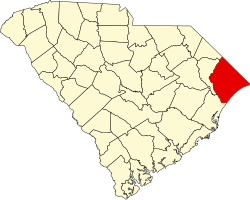
County | Horry |
Time zone | Eastern |
ZIP Code | 29526 |
Area code | 843 |
Hickory Grove is an unincorporated community in Horry County, South Carolina, United States, [1] along South Carolina Highway 905. Hickory Grove is located east of Conway and west of Longs.
Catawba County is a county in the U.S. state of North Carolina. As of the 2020 census, the population was 160,610. Its county seat is Newton, and its largest community is Hickory.
Alexander County is a county established in the U.S. state of North Carolina in 1847. As of the 2020 census, the population was 36,444. Its county seat is Taylorsville. Alexander County is part of the Hickory-Lenoir-Morganton, NC Metropolitan Statistical Area.
Hickory Grove is a town in York County, South Carolina, United States. The population was 449 at the 2020 census..
Hickory is a city in North Carolina primarily located in Catawba County and is the 25th most populous city in North Carolina. It is located approximately 60 miles (97 km) northwest of Charlotte. Hickory's population in the 2022 United States Census Bureau estimate was 44,084. Hickory is the main city of the Hickory–Lenoir–Morganton Metropolitan Statistical Area, which had a population of 368,347 in the 2022 census.
Hickory Grove may refer to several places in the United States:
The Catawba River is a major river located in the Southeastern United States. It originates in Western North Carolina and flows into South Carolina, where it later becomes known as the Wateree River. The river is approximately 220 miles (350 km) long. It rises in the Appalachian Mountains and drains into the Piedmont, where it has been impounded through a series of reservoirs for flood control and generation of hydroelectricity. The river is named after the Catawba tribe of Native Americans, which lives on its banks. In their language, they call themselves "yeh is-WAH h’reh", meaning "people of the river."
Sassafras Mountain is the highest point in the state of South Carolina, United States. It is in the Blue Ridge Mountains, part of the Appalachian Mountains. An observation tower opened on top of Sassafras Mountain in 2019.
The Broad River is a principal tributary of the Congaree River, about 150 miles (240 km) long, in western North Carolina and northern South Carolina in the United States. Via the Congaree, it is part of the watershed of the Santee River, which flows to the Atlantic Ocean.
Hickory is a census-designated place in Graves County, Kentucky, United States., which is located north of Mayfield and 18 miles (29 km) south of Paducah in far western Kentucky.
Chimney Rock State Park is a North Carolina state park in Chimney Rock, Rutherford County, North Carolina in the United States. The 8,014-acre (32.43 km2) park is located 25 miles (40 km) southeast of Asheville, North Carolina, and is owned and managed by the state of North Carolina.
John Peter Richardson II was the 59th Governor of South Carolina from 1840 to 1842.
Carya myristiciformis, the nutmeg hickory, a tree of the Juglandaceae or walnut family, also called swamp hickory or bitter water hickory, is found as small, possibly relict populations across the Southern United States and in northern Mexico on rich moist soils of higher bottom lands and stream banks. Little is known of the growth rate of nutmeg hickory. Logs and lumber are sold mixed with other hickories. The nuts are an oil-rich food for wildlife.
Hickory Grove Township is one of eleven townships in Benton County, Indiana. As of the 2020 census, its population was 398 and it contained 168 housing units. It was organized in March 1876 and named for a grove of hickory trees that grew within its borders in the 19th century.
Dunn is an extinct town in Hickory Grove Township, Benton County, in the U.S. state of Indiana.
Hickory Grove is an unincorporated community in Greenbrier County, West Virginia, United States. Hickory Grove is 7.5 miles (12.1 km) north of Alderson.
Hickory Tavern, is an unincorporated community in Laurens County, South Carolina, United States. It is classified by the federal government as a class U6 populated place. It is centered at the intersection of US Route 76 and South Carolina Highway 101.
The Charlotte metropolitan area, sometimes referred to as Metrolina, is a metropolitan area of the U.S. states of North and South Carolina, containing the city of Charlotte. The metropolitan area also includes the cities of Gastonia, Concord, Huntersville, and Rock Hill as well as the large suburban area in the counties surrounding Mecklenburg County, which is at the center of the metro area. Located in the Piedmont, it is the largest metropolitan area in the Carolinas, and the fourth largest in the Southeastern United States. The Charlotte metropolitan area is one of the fastest growing metropolitan areas in the United States.
South Carolina Highway 211 (SC 211) is a 27.380-mile (44.064 km) primary state highway in the U.S. state of South Carolina. The highway serves the rural areas of southern Cherokee and western York counties.
South Carolina Highway 97 (SC 97) is a 89.800-mile (144.519 km) state highway in the U.S. state of South Carolina. The highway connects Camden, Great Falls, Chester, and Hickory Grove.
The Wilderness Gateway State Trail is a unit of the North Carolina state park system in Burke, Catawba, McDowell and Rutherford Counties, North Carolina in the United States. The State Trail is planned as a hiking trail connecting the Town of Valdese, the City of Hickory, the Overmountain Victory National Historic Trail, South Mountains State Park and Chimney Rock State Park The trail is a collaboration between local governments and the state, with development coordinated by the North Carolina Division of Parks and Recreation (NCDPR).