Wampee, South Carolina | |
|---|---|
 | |
| Country | United States |
| State | South Carolina |
| County | Horry |
| Time zone | Eastern |
| ZIP Code | 29566, 29568 |
| Area code | 843 |
Wampee is an unincorporated community in Horry County, South Carolina, United States, along South Carolina Highway 90. Wampee is located near North Myrtle Beach across from the Intracoastal Waterway. Robert Edge Parkway starts here.
Municipalities and communities of Horry County, South Carolina, United States | ||
|---|---|---|
| Cities | 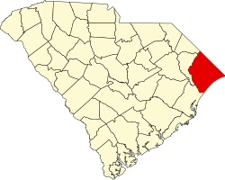 | |
| Towns | ||
| CDPs | ||
| Other communities | ||
33°51′38″N78°44′3″W / 33.86056°N 78.73417°W
| | This South Carolina state location article is a stub. You can help Wikipedia by expanding it. |