Wedgefield, South Carolina

Last updated

Wedgefield, South Carolina
Wedgefield SC.jpg
Wedgefield, South Carolina
Country United States
State South Carolina
County Sumter
Area
  Total
73.23 sq mi (189.7 km2)
  Land71.9 sq mi (186 km2)
  Water0.33 sq mi (0.9 km2)
Elevation
249 ft (76 m)
Population
 (2000) [1]
  Total
3,376
Time zone UTC-5 (Eastern (EST))
  Summer (DST) UTC-4 (EDT)
Zip Code
29168

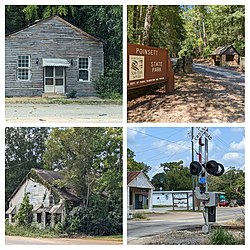
Wedgefield is an unincorporated community and census designated place (CDP) in the High Hills of Santee area in western Sumter County, South Carolina, United States. Wedgefield is also a Census Designated Place (CDP). Wedgefield was so named because its location was likened to a "wedge" into the High Hills of Santee. [2] In the 18th and 19th centuries it was the location of many plantations, notably those of the Singleton family, which produced First Lady of the United States, Angelica Singleton Van Buren. [3] Today the plantations are gone except for their cemeteries and Wedgefield is today noted as the location of a state park, a state forest and other recreational places. When the railroad came through in the 19th century, the commercial center of Wedgefield developed at the intersection of the railroad, Kings Highway (South Carolina Highway 261) and Wedgefield Road (South Carolina Highway 763). It has its own post office with the Zip Code of 29168.

Contents

Wedgefield had a population of 3,376 in 2000 on a Zip Code-based estimate. Housing units were 1,343. Land area is 71.9 square miles (186 km2) while water area is 0.33 square miles. [1]

Demographics

Wedgefield first appeared as a census designated place in the 2010 U.S. Census.

2020 census

Wedgefield CDP, South Carolina – Racial and ethnic composition
Note: the US Census treats Hispanic/Latino as an ethnic category. This table excludes Latinos from the racial categories and assigns them to a separate category. Hispanics/Latinos may be of any race.
Race / Ethnicity (NH = Non-Hispanic)Pop 2010 [4] Pop 2020 [5] % 2010% 2020
White alone (NH)1,02287663.28%58.13%
Black or African American alone (NH)50946931.52%31.12%
Native American or Alaska Native alone (NH)360.19%0.40%
Asian alone (NH)1891.11%0.60%
Pacific Islander alone (NH)000.00%0.00%
Other race alone (NH)1100.06%0.66%
Mixed race or Multiracial (NH)33932.04%6.17%
Hispanic or Latino (any race)29441.80%2.92%
Total1,6151,507100.00%100.00%

Places of interest

Transportation

South Carolina Highway 261, Kings Highway, is the main north–south road in Wedgefield. It runs north to Stateburg and south to Pinewood. Wedgefield Road (South Carolina Highway 763) begins in Wedgefield and runs east to Sumter. [9] [10] CSX Transportation, formerly the Seaboard Coast Line Railroad runs into Wedgefield from Sumter just north of Wedgefield Road and continues to the west. There is no passenger service to Wedgefield.

Cemeteries

Cemeteries in the Wedgefield area include: [11]

Notable people

Portrait of Sarah Angelica Singleton Van Buren by Henry Inman (1842) Angelica Singleton.jpg
Portrait of Sarah Angelica Singleton Van Buren by Henry Inman (1842)

Media

WIBZ is licensed to Wedgefield.

References

  1. 1 2 "Wedgefield, South Carolina (SC) ~ population data, races, housing & economy".
  2. "Places in Sumter District, South Carolina".
  3. "SCDAH".
  4. "P2 Hispanic or Latino, and Not Hispanic or Latino by Race – 2010: DEC Redistricting Data (PL 94-171) – Wedgefield CDP, South Carolina". United States Census Bureau .
  5. "P2 Hispanic or Latino, and Not Hispanic or Latino by Race – 2020: DEC Redistricting Data (PL 94-171) – Wedgefield CDP, South Carolina". United States Census Bureau .
  6. "Palmetto Conservation Foundation".
  7. "SCFC Manchester State Forest".
  8. SC Parks listing for Poinsett State Park
  9. "Maps of Sumter County, South Carolina".
  10. Another map of Sumter County
  11. "Place List: wedgefield: Singleton and Related Families".

Coordinates 33.893° N80.518°W

33°53′35″N80°31′05″W / 33.893°N 80.518°W / 33.893; -80.518