
Sumter County is a county located in the U.S. state of South Carolina. As of the 2020 census, the population was 105,556. Its county seat is Sumter.
Stateburg is a census-designated place (CDP) in the High Hills of Santee in Sumter County, South Carolina, United States. The population was 1,380 at the 2010 census. It is included in the Sumter, South Carolina Metropolitan Statistical Area. Stateburg is located within the larger Stateburg Historic District.

Sumter is a city in and the county seat of Sumter County, South Carolina, United States. The city makes up the Sumter, SC Metropolitan Statistical Area. Sumter County, along with Clarendon and Lee counties, form the core of Sumter–Lee–Clarendon tri-county area of South Carolina that includes three counties straddling the border of the Sandhills, Pee Dee, and Lowcountry regions. The population was 43,463 at the 2020 census, making it the 9th-most populous city in the state.

Thomas Sumter was an American military officer, planter, and politician who served in the Continental Army as a brigadier-general during the Revolutionary War. After the war, Sumter was elected to the House of Representatives and to the Senate, where he served from 1801 to 1810, when he retired. Sumter was nicknamed the "Fighting Gamecock" for his military tactics during the Revolutionary War.

The Church of the Holy Cross is a historic Anglican church at 335 North Kings Highway in Stateburg, South Carolina. Built in 1850-52 to a design by noted South Carolina architect Edward C. Jones, it is a notable example of rammed earth construction with relatively high style Gothic Revival styling. It was designated a National Historic Landmark for its architecture in 1973.

Borough House Plantation, also known as Borough House, Hillcrest Plantation and Anderson Place, is an historic plantation on South Carolina Highway 261, 0.8 miles (1.3 km) north of its intersection with U.S. Route 76/US Route 378 in Stateburg, in the High Hills of Santee near Sumter, South Carolina. A National Historic Landmark, the plantation is noted as the largest assemblage of high-style pisé structures in the United States. The main house and six buildings on the plantation were built using this technique, beginning in 1821. The plantation is also notable as the home of Confederate Army General Richard H. Anderson.

Hopsewee Plantation, also known as the Thomas Lynch, Jr., Birthplace or Hopsewee-on-the-Santee, is a plantation house built in 1735 near Georgetown, South Carolina, in the Lowcountry. It was the main house of a rice plantation and the birthplace of Thomas Lynch, Jr., a Founding Father who was a signer of the Declaration of Independence.

Millford Plantation is a historic farmstead and plantation house located on SC 261 west of Pinewood, South Carolina. It was sometimes called Manning's Folly, because of its remote location in the High Hills of Santee section of the state and its elaborate details. Designated as a National Historic Landmark, it is regarded as one of the finest examples of Greek Revival residential architecture in the United States. The house has been restored and preserved along with many of its original Duncan Phyfe furnishings.

St. Mark's Episcopal Church is an historic Episcopal church located in the High Hills of Santee west of Pinewood, South Carolina. On January 20, 1978, it was added to the National Register of Historic Places as St. Mark's Church.
Singleton's Graveyard is an historic plantation cemetery located off SC 261 in the High Hills of Santee, 6 miles south of Wedgefield, South Carolina. On May 13, 1976, it was added to the National Register of Historic Places.

Wedgefield is an unincorporated community and census designated place (CDP) in the High Hills of Santee area in western Sumter County, South Carolina, United States. Wedgefield is also a Census Designated Place (CDP). Wedgefield was so named because its location was likened to a "wedge" into the High Hills of Santee. In the 18th and 19th centuries it was the location of many plantations, notably those of the Singleton family, which produced First Lady of the United States, Angelica Singleton Van Buren. Today the plantations are gone except for their cemeteries and Wedgefield is today noted as the location of a state park, a state forest and other recreational places. When the railroad came through in the 19th century, the commercial center of Wedgefield developed at the intersection of the railroad, Kings Highway and Wedgefield Road. It has its own post office with the Zip Code of 29168.
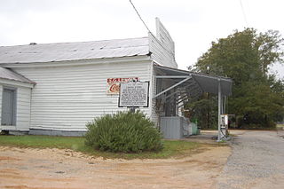
The Lenoir Store built in 1869 is an American historic general store building located in the High Hills of Santee community of Horatio, South Carolina. It stands on the same site where the Lenoir family has operated a general store since before 1808 and "is the oldest business establishment in Sumter County". Since 1900 it has served as the post office for Horatio Zip Code 29062. On July 3, 1997, it was added to the National Register of Historic Places. As of that date, it was still being operated by members of the Lenoir family. Lenoir is pronounced le-nore or len-wa by some of its more northern members.
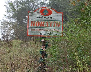
Horatio is an unincorporated community in the High Hills of Santee area in western Sumter County, South Carolina, United States.
Hagood is an unincorporated community in the High Hills of Santee area in western Sumter County, South Carolina, United States. It lies west of South Carolina Highway 261, north of Stateburg and is the location of Magnolia Hall, which is listed on the National Register of Historic Places. Its mail now comes from Rembert zip code 29128. The community was originally called Sander's Station by the South Carolina Railway, apparently for Dr. Swepson Saunders, the owner of Magnolia Hall plantation, on which it was located, but was renamed Hagood for Johnson Hagood, brigadier general in the Confederate States Army and later governor of South Carolina.

Magnolia Hall is an historic plantation located in the High Hills of Santee at 2025 Horatio-Hagood Road, Hagood, South Carolina. Its Greek Revival plantation house was built in 1821 by its owner Isaac Barnes. After Dr. Swepson Saunders bought the property in 1853, he added onto it in 1855 and 1860.

High Hills of Santee Baptist Church is an historic Southern Baptist church located in the High Hills of Santee in Stateburg, near Dalzell in Sumter County, South Carolina. Its congregation was founded in 1772 and the present church was built in 1848. Its first pastor was Richard Furman, who went on to become one of South Carolina's most influential ministers. Furman University was named for him. Many of the Baptist churches in the area are offshoots of this church.
The High Hills of Santee, sometimes known as the High Hills of the Santee, is a long, narrow hilly region in the western part of Sumter County, South Carolina. It has been called "one of the state's most famous areas". The High Hills of Santee region lies north of the Santee River and east of the Wateree River, one of the two rivers that join to form the Santee. It extends north almost to the Kershaw county line and northeasterly to include the former summer resort town of Bradford Springs. Since 1902 the town has been included in Lee County.
William Ellison Jr., born April Ellison, was an American cotton gin maker and blacksmith in South Carolina, and former African-American slave who achieved considerable success as a slaveowner before the American Civil War. He eventually became a major planter and one of the wealthiest property owners in the state. According to the 1860 census, he owned up to 68 black slaves, making him the largest of the 171 black slaveholders in South Carolina. He held 63 slaves at his death and more than 900 acres (360 ha) of land. From 1830 to 1865 he and his sons were the only free blacks in Sumter County, South Carolina to own slaves. The county was largely devoted to cotton plantations, and the majority population were slaves.
Milldam Rice Mill and Rice Barn, also known as Kinloch Plantation, is a historic rice plantation property and national historic district located near Georgetown, Georgetown County, South Carolina. The district encompasses 1 contributing building, 1 contributing site, and 3 contributing structures. This rice mill and rice barn are associated with Milldam, one of several productive rice plantations on the Santee River. Agricultural features include examples of historic ricefields, including canals, dikes and trunks. The Rice Barn was destroyed by Hurricane Hugo in 1989.

Rip Raps Plantation, also known as the James McBride Dabbs House, is a historic plantation house and national historic district located near Sumter, Sumter County, South Carolina. It was the home of James McBride Dabbs, author and leading advocate for social justice and civil rights (1896-1970).


