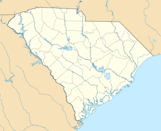
Saluda County is a county in the U.S. state of South Carolina. As of the 2010 census, the population was 19,875. Its county seat is Saluda. The county was formed from northern and eastern portions of Edgefield County.

The Little Kanawha River is a tributary of the Ohio River, 169 mi (269 km) long, in western West Virginia in the United States. Via the Ohio, it is part of the watershed of the Mississippi River, draining an area of 2,320 mi² (6,009 km²) on the unglaciated portion of the Allegheny Plateau. It served as an important commercial water route in the early history of West Virginia, particularly in the logging and petroleum industries.
Lake Murray Country is a large area of South Carolina, United States; the region includes the counties of Newberry, Saluda, Lexington, and Richland.

The Broad River is a principal tributary of the Congaree River, about 150 miles (240 km) long, in western North Carolina and northern South Carolina in the United States. Via the Congaree, it is part of the watershed of the Santee River, which flows to the Atlantic Ocean.

The Whetstone River is a 12.7-mile-long (20.4 km) tributary of the Minnesota River in northeastern South Dakota and a very small portion of western Minnesota in the United States. Via the Minnesota River, it is part of the watershed of the Mississippi River.

The Reedy River is a tributary of the Saluda River, about 65 miles (105 km) long, in northwestern South Carolina in the United States. Via the Saluda and Congaree Rivers, it is part of the watershed of the Santee River, which flows to the Atlantic Ocean.

The Uwharrie River is a river, about 60 mi (100 km) long, in the Piedmont region of central North Carolina in the United States. It is a tributary of the Pee Dee River, which flows to the Atlantic Ocean.
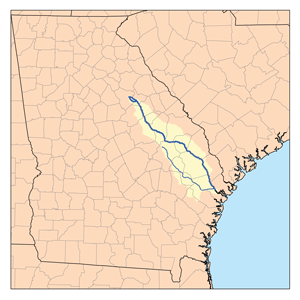
The Canoochee River is a 108-mile-long (174 km) river in southeastern Georgia in the United States. It is a tributary of the Ogeechee River, which flows to the Atlantic Ocean. In 1738 the Trustees of the colony mentioned the proposed house and ferry boat over the 'Cooanoochi River'.
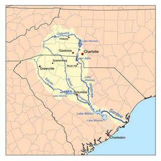
The Wateree River, about 75 mi (120 km) long, is a tributary of the Santee River in central South Carolina in the United States, which flows to the Atlantic Ocean. Its name recalls the now-extinct Wateree Native Americans, who lived in the area until displaced by European settlers.
The Banister River is a tributary of the Dan River, about 65 mi (105 km) long, in southern Virginia in the United States. Via the Dan, it is part of the watershed of the Roanoke River, which flows to the Atlantic Ocean. It rises on Brier Mountain in western Pittsylvania County and flows generally eastwardly into Halifax County, past the town of Halifax. It joins the Dan River 6 mi (9.7 km) east of the town of South Boston.
The First Broad River is a tributary of the Broad River, about 60 mi (95 km) long in western North Carolina in the United States. Via the Broad and Congaree Rivers, it is part of the watershed of the Santee River, which flows to the Atlantic Ocean.
The Pacolet River is a tributary of the Broad River, about 50 miles (80 km) long, in northwestern South Carolina in the United States. One of its principal headwaters tributaries also drains a small portion of western North Carolina. Via the Broad and Congaree Rivers, it is part of the watershed of the Santee River, which flows to the Atlantic Ocean. The stream's name has also been spelled historically as "Pacolate River".
There is a Pacolet River in Polk County in Florida.
The Second Broad River is a tributary of the Broad River in western North Carolina in the United States. Via the Broad and Congaree rivers, it is part of the watershed of the Santee River, which flows to the Atlantic Ocean.
The Enoree River is a tributary of the Broad River, 85 mi (137 km) long, in northwestern South Carolina in the United States. Via the Broad and Congaree Rivers, it is part of the watershed of the Santee River, which flows to the Atlantic Ocean.
The Sandy River and its tributary the Little Sandy River are short rivers in north-central South Carolina in the United States. The Sandy is a tributary of the Broad River; via the Broad and Congaree Rivers, it is part of the watershed of the Santee River, which flows to the Atlantic Ocean.
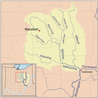
Killbuck Creek is a tributary of the Walhonding River, 81.7 mi long, in north-central Ohio in the United States. Via the Walhonding, Muskingum and Ohio Rivers, it is part of the watershed of the Mississippi River. It drains an area of 613 mi².
The Mitchell River is a tributary of the Yadkin River in northwestern North Carolina in the United States. Via the Yadkin it is part of the watershed of the Pee Dee River, which flows to the Atlantic Ocean. According to the Geographic Names Information System, it has also been known historically as "Mitchells River," "Mitchels River," and "Mountain Creek."
The Roaring River is a tributary of the Yadkin River in northwestern North Carolina in the United States. Via the Yadkin it is part of the watershed of the Pee Dee River, which flows to the Atlantic Ocean. According to the Geographic Names Information System, it has also been known historically as "Roaring Creek." The river's name comes from its headwaters in the Blue Ridge Mountains, where it flows through a series of small waterfalls.
The Ararat River is a tributary of the Yadkin River in southwestern Virginia and northwestern North Carolina in the United States. Via the Yadkin it is part of the watershed of the Pee Dee River, which flows to the Atlantic Ocean.


