Related Research Articles

The Au Sable River is a 138-mile-long (222 km) river in the Lower Peninsula of the U.S. state of Michigan. Rising in the Northern Lower Peninsula, the river flows in a generally southeasterly direction to its mouth at Lake Huron at the communities of Au Sable and Oscoda. It is considered one of the best brown trout fisheries east of the Rockies and has been designated a blue ribbon trout stream by the Michigan Department of Natural Resources. A map from 1795 located in the United States Gazetteer calls it the Beauais River. In French, the river is called the Rivière au sable, literally "Sand River".

Webb is the northernmost town in Herkimer County, New York, United States. As of the 2020 Census it had a population of 1,797.

The Feather River is the principal tributary of the Sacramento River, in the Sacramento Valley of Northern California. The river's main stem is about 73 miles (117 km) long. Its length to its most distant headwater tributary is just over 210 miles (340 km). The main stem Feather River begins in Lake Oroville, where its four long tributary forks join—the South Fork, Middle Fork, North Fork, and West Branch Feather Rivers. These and other tributaries drain part of the northern Sierra Nevada, and the extreme southern Cascades, as well as a small portion of the Sacramento Valley. The total drainage basin is about 6,200 square miles (16,000 km2), with approximately 3,604 square miles (9,330 km2) above Lake Oroville.

The Missisquoi River is a transboundary river of the east shore of Lake Champlain, approximately 80 miles (130 km) long, in northern Vermont in the United States and southern Quebec in Canada.
McPhersonville is an unincorporated community in eastern Hampton County, South Carolina, United States, near the county's borders with Beaufort and Jasper counties. Once an important center of affluence and culture in colonial Prince William Parish, McPhersonville is now little more than a marked location on a secondary road between Yemassee and Early Branch.
Meshoppen Creek is a tributary of the Susquehanna River in Susquehanna and Wyoming counties, Pennsylvania, in the United States. It is approximately 30.6 miles (49.2 km) long and flows through Bridgewater Township, Dimock Township, and Springville Township in Susquehanna County and Lemon Township, Washington Township, Meshoppen Township, and Meshoppen in Wyoming County. The watershed of the creek has an area of 114 square miles (300 km2). It is possible to canoe on 17.0 miles (27.4 km) of Meshoppen Creek.
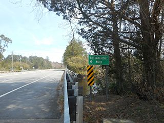
The Salkehatchie River originates near the City of Barnwell, South Carolina and accepts drainage from Turkey Creek and Whippy Swamp before merging with the Little Salkehatchie River to form the Combahee River Basin, which empties into Saint Helena Sound and the Atlantic Ocean. Prior to the confluence, the Little Salkehatchie River accepts drainage from Lemon Creek, Buckhead Creek, and Willow Swamp.
The Coosawhatchie River (koos-uh-HATCH-ee) is a river in the U.S. state of South Carolina. It rises in Allendale County near the towns of Allendale and Fairfax and accepts drainage from Swallow Savanna, Harters Pond, Little Duck Branch, Duck Branch, Beech Branch (LevyBay), Blood Hill Creek, and Cedar Branch. The channel flows southeast to the Broad River. It is 50 mi/80 km long.

The Sebasticook River is a 76-mile-long (122 km) river in the central part of Maine, in the United States. From its source in Dexter, the upper "Main Stream" section flows generally west and south 30 miles (48 km) to Great Moose Lake. From the outlet of the lake in Hartland, the Sebasticook flows 41 miles (66 km) south to the Kennebec River in Winslow.
Shenandoah Creek is a tributary of Mahanoy Creek in Schuylkill County, Pennsylvania, in the United States. It is at least 5 miles (8.0 km) long and flows through Shenandoah, West Mahanoy Township, Butler Township, and Girardville.
The Black River is a tributary of Lake Memphremagog, over 30 miles (48 km) long, in northern Vermont in the United States. It is one of the four major rivers in Orleans County. It is the longer but least powerful of the two rivers contained solely within the county. There are no longer any damsites.

The Baker Branch Saint John River is a 48.0-mile-long (77.2 km) river. This river is a tributary of the Saint John River, flowing in the Maine North Woods, in Maine, in the Northeastern United States.

The Medomak River, historically known as the Muscongus River, is a 40-mile-long (64 km) river in Maine. From its source in Liberty, the river winds 32 miles (51 km) south to the head of its tidal river estuary in Waldoboro, then about 8 miles (13 km) south to Bremen. The river flows through Hockomock Channel into the head of Muscongus Bay. Medomak is Abenaki for "place (river) of many alewives".
The North Branch Penobscot River is a river in Somerset County, Maine. From its source at the outlet of Little Bog about 10 miles (16 km) east of the Canada–United States border in Maine Township 6, Range 17, WELS, the river runs 27.8 miles (44.7 km) southwest and southeast to its drowned confluence with the South Branch of the Penobscot River in Seboomook Lake in Pittston Academy Grant.

The West Branch Penobscot River is a 117-mile-long (188 km) tributary of the Penobscot River through the North Maine Woods in Maine. The river is also known as Abocadneticook, Kahgognamock, and Kettegwewick.

The mimic shiner is a species of North American cyprinid freshwater fish in the genus Notropis. The genus Notropis is commonly known as the eastern shiners. It is native to areas of the Hudson Bay drainage, Great Lakes drainage, much of the Mississippi River basin including areas of Tennessee, Virginia, North Carolina, and regions of the Gulf of Mexico extending from Mobile Bay to the drainage of Texas. However, this particular species can be found in other places such as the Atlantic Coast drainage in Connecticut and Housatonic rivers. This genus is usually characterized by almost all having a complete lateral line, 8 dorsal fin rays, a premaxillae protactile, and a silvery or speckled peritoneum. As the common name indicates, this species is difficult to classify in the wild because it looks similar to many other shiners. In fact, some even hypothesize that this species is actually a complexity of many cryptic species. While this is the case, it is important to take more caution to not misidentify this species and to understand its impact on introduced areas.
Carp River is a 21.9-mile-long (35.2 km) river in Marquette County in the U.S. state of Michigan. The Carp River is formed by the outflow of Deer Lake in Ishpeming Township north of Ishpeming at 46°31′58″N87°40′01″W in the Upper Peninsula.
East Branch Tunkhannock Creek is a tributary of Tunkhannock Creek in Susquehanna County, Pennsylvania, in the United States. It is approximately 19 miles (31 km) long and flows through Gibson Township, Herrick Township, Clifford Township, and Lenox Township, Susquehanna County, Pennsylvania. The watershed of the creek has an area of 68.3 square miles (177 km2). The creek has four named tributaries: Little Creek, Tinker Creek, Dundaff Creek, and Idlewild Creek. It is not designated as an impaired waterbody and is a freestone stream in its upper reaches. The topography of the watershed has been described as "rough and hilly".
References
- ↑ "Little Salkehatchie River". Geographic Names Information System . United States Geological Survey, United States Department of the Interior . Retrieved December 12, 2019.
- ↑ "Little Salkehatchie River (03050207-060)" (PDF). South Carolina Department of Health and Environmental Control . Retrieved 2 November 2006.
32°47′32″N80°52′48″W / 32.7922°N 80.8801°W