Related Research Articles

Montgomery County is a county in the U.S. state of Tennessee. As of the 2020 United States census, the population was 220,069. The county seat is Clarksville. The county was created in 1796. Montgomery County is included in the Clarksville, TN–KY Metropolitan Statistical Area.

Clarksville is the county seat of Montgomery County, Tennessee, United States. It is the fifth-largest city in the state, after Nashville, Memphis, Knoxville, and Chattanooga. The city had a population of 166,722 as of the 2020 United States census.

The Cumberland River is a major waterway of the Southern United States. The 688-mile-long (1,107 km) river drains almost 18,000 square miles (47,000 km2) of southern Kentucky and north-central Tennessee. The river flows generally west from a source in the Appalachian Mountains to its confluence with the Ohio River near Paducah, Kentucky, and the mouth of the Tennessee River. Major tributaries include the Obey, Caney Fork, Stones, and Red Rivers.

The Wolf River is a 105-mile-long (169 km) alluvial river in western Tennessee and northern Mississippi, whose confluence with the Mississippi River was the site of various Chickasaw, French, Spanish and American communities that eventually became Memphis, Tennessee. It is estimated to be about 12,000 years old, formed by Midwestern glacier runoff carving into the region's soft alluvial soil. It should not be confused with The Wolf River which flows primarily in Middle Tennessee and southern Kentucky. The Wolf River rises in the Holly Springs National Forest at Baker's Pond in Benton County, Mississippi, and flows northwest into Tennessee, before entering the Mississippi River north of downtown Memphis.

The Harpeth River, 115 miles (185 km) long, is one of the major streams of north-central Middle Tennessee, United States, and one of the major tributaries of the Cumberland River. Via the Cumberland and the Ohio Rivers, it is part of the Mississippi River watershed. The lower portion of the Harpeth is designated as a "scenic river" under the Tennessee Scenic Rivers Act.

The Collins River is a 67-mile-long (108 km) stream in the east-central portion of Middle Tennessee in the United States. It is a tributary of the Caney Fork, and is part of the Cumberland, Ohio and Mississippi watersheds. The river drains the scenic Savage Gulf area, located just below the river's source, and empties into Great Falls Lake at Rock Island State Park.

The Rocky River is a 31.0-mile-long (49.9 km) stream in the east-central portion of Middle Tennessee in the United States. It is a tributary of the Caney Fork River, and is part of the Cumberland, Ohio and Mississippi watersheds. The lower portion of the river is part of the reservoir created by Great Falls Dam, which is located near the river's confluence with the Caney Fork.

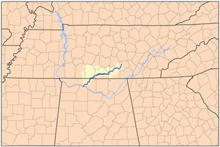
The Red River, 100 miles (161 km) long, is a major stream of north-central Tennessee and south-central Kentucky, and a major tributary of the Cumberland River.
The Elk River is a tributary of the Tennessee River in the U.S. states of Tennessee and Alabama. The river is about 195 miles (314 km) long.

Rock Creek is a free-flowing tributary of the Potomac River that empties into the Atlantic Ocean via the Chesapeake Bay. The 32.6-mile (52.5 km) creek drains about 76.5 square miles (198 km2). Its final quarter-mile is affected by tides.
Port Royal State Historic Park is a 26 acre historic area on the border of Montgomery and Robertson. The community of Port Royal is the namesake of the site. Port Royal existed as a town from 1797 to 1940, when the post office officially closed. The Red River runs through the center of the park. The park was established to preserve the former town and the elements of early Tennessee history, the history of the Red River Valley, as well as the heritage of the Trail of Tears and the Black Patch Tobacco Wars.

Coyote Creek is a river that flows through the Santa Clara Valley in Northern California. Its source is on Mount Sizer, in the mountains east of Morgan Hill. It eventually flows into Anderson Lake in Morgan Hill and then northwards through Coyote Valley to San Jose, where it empties into San Francisco Bay.
Port Royal is an unincorporated community on the border of Montgomery and Robertson counties, Tennessee. It is home to Port Royal State Park and is located at the confluence of the Red River and Sulphur Fork Creek.

The Nashville metropolitan area is a metropolitan statistical area centered on Nashville, Tennessee, the capital and largest city in Tennessee, in the United States. With a population of just over 2 million, it is the most populous metropolitan area in Tennessee. It is also the largest metropolitan area in Tennessee, in terms of land area.

Crab Creek is a stream in the U.S. state of Washington. Named for the presence of crayfish, it is one of the few perennial streams in the Columbia Basin of central Washington, flowing from the northeastern Columbia River Plateau, roughly 5 km (3.1 mi) east of Reardan, west-southwest to empty into the Columbia River near the small town of Beverly. Its course exhibits many examples of the erosive powers of extremely large glacial Missoula Floods of the late Pleistocene, which scoured the region. In addition, Crab Creek and its region have been transformed by the large-scale irrigation of the Bureau of Reclamation's Columbia Basin Project (CBP), which has raised water table levels, significantly extending the length of Crab Creek and created new lakes and streams.

Johnson Creek is a 25-mile (40 km) tributary of the Willamette River in the Portland metropolitan area of the U.S. state of Oregon. Part of the drainage basin of the Columbia River, its catchment consists of 54 square miles (140 km2) of mostly urban land occupied by about 180,000 people as of 2012. Passing through the cities of Gresham, Portland, and Milwaukie, the creek flows generally west from the foothills of the Cascade Range through sediments deposited by glacial floods on a substrate of basalt. Though polluted, it is free-flowing along its main stem and provides habitat for salmon and other migrating fish.
Fanno Creek is a 15-mile (24 km) tributary of the Tualatin River in the U.S. state of Oregon. Part of the drainage basin of the Columbia River, its watershed covers about 32 square miles (83 km2) in Multnomah, Washington, and Clackamas counties, including about 7 square miles (18 km2) within the Portland city limits.
The Nonconnah Creek is a 29.7-mile-long (47.8 km) waterway in southwest Tennessee. It starts in extreme southeastern Shelby County, Tennessee, near the town of Collierville. From there, it flows westward, forming the southern border of Germantown. The creek continues to flow west through Memphis and through Whitehaven. Nonconnah Creek empties into McKellar Lake, an oxbow of the Mississippi River. There are three major expressways that follow most of its route. These are Interstate 55, Interstate 240, and Tennessee State Route 385, formerly named and still locally referred to as "Nonconnah Parkway".

Alamitos Creek or Los Alamitos Creek is a 7.7-mile-long (12.4 km) creek in San Jose, California, which becomes the Guadalupe River when it exits Lake Almaden and joins Guadalupe Creek. Los Alamitos Creek is located in Almaden Valley and originates from the Los Capitancillos Ridge in the Santa Cruz Mountains, near New Almaden. This creek flows through the Valley's Guadalupe Watershed, which is owned by the Santa Clara Valley Water District. The creek flows in a generally northwesterly direction after rounding the Los Capitancillos Ridge and the town of New Almaden, in the southwest corner, before ambling along the Santa Teresa Hills on northeast side of the Almaden Valley. Its environment has some relatively undisturbed areas and considerable lengths of suburban residential character. Originally called Arroyo de los Alamitos, the creek's name is derived from "little poplar", "alamo" being the Spanish word for "poplar" or "cottonwood".

Richland Creek is a stream in the western part of Nashville, Tennessee, in Davidson County. It winds for 28 miles (45 km) through the Nashville suburbs of Belle Meade and Forest Hills and eventually flows into the Cumberland River near Rock Harbor Marina at the end of Robertson Avenue. This is one of at least five streams by the name of "Richland Creek" in various regions of Tennessee.
References
- ↑ Google (5 February 2017). "Passenger Creek" (Map). Google Maps . Google. Retrieved 5 February 2017.
- ↑ "885 Passenger Creek Rd, Adams, TN 37010 - Zillow". Zillow Inc.
- ↑ "The Great Flood of 2010". 8 May 2010.
- ↑ "Flood Information - Montgomery County Government".
- ↑ Ball, Edward. "Retracing Slavery's Trail of Tears".
- ↑ "Maps - Trail Of Tears National Historic Trail (U.S. National Park Service)".