Caney Fork River

Last updated
Caney Fork River
Caney Fork River canoeing.jpg
Canoeing on the upper Caney Fork
Caney Fork Watershed Map.png
Caney Fork watershed
Location
CountryUnited States
StateTennessee
Physical characteristics
SourceNear Campbell Junction in Cumberland County
  coordinates 36°02′36″N85°09′30″W / 36.04333°N 85.15833°W / 36.04333; -85.15833 [1]
  elevation1,960 ft (600 m) [2]
Mouth Cumberland River (Old Hickory Lake) at Carthage
  coordinates
36°14′20″N85°56′29″W / 36.23889°N 85.94139°W / 36.23889; -85.94139 [1]
  elevation
446 ft (136 m) [1]
Length143 mi (230 km) [3]
Basin size1,771 sq mi (4,590 km2) [4]
Discharge 
  locationGreat Falls Dam powerhouse [5] (mean for water years 1915-1983) [6]
  average3,177 cu ft/s (90.0 m3/s)(mean for water years 1915-1983) [6]
  minimum25 cu ft/s (0.71 m3/s)
August 1951 [6]
  maximum210,000 cu ft/s (5,900 m3/s)
March 1929 [6]
Basin features
Tributaries 
  left Rocky River, Collins River, Smith Fork Creek
  right Calfkiller River, Falling Water River, Mine Lick Creek, Indian Creek

The Caney Fork River is a river that flows through central Tennessee in the United States, draining a substantial portion of the southwestern Cumberland Plateau and southeastern Highland Rim regions. [7] It is a major tributary of the Cumberland River, and is part of the Cumberland, Ohio and Mississippi basins. The river is 143 miles (230 km) long, and its watershed covers 1,771 square miles (4,590 km2) in eleven counties. Monterey, Baxter, Sparta, Smithville, McMinnville, Altamont, Spencer and Gordonsville are among the towns that are at least partially drained by the river.

Contents

The Caney Fork flows through two impoundments Center Hill Lake and Great Falls Lake both of which create sizeable artificial lakes. The river's basin is home to numerous protected lands and recreational areas, including five state wilderness areas, six interpretive areas, and a wildlife management area. [4] Two state parks Edgar Evins State Park and Rock Island State Park are located along the river, and three others Fall Creek Falls State Park, Burgess Falls State Park and South Cumberland State Park are located within its basin. The river is a popular stream for canoeing and kayaking.

The name "Caney Fork" comes from the dense cane breaks that grew along the river's banks when European explorers first arrived in the area. [8]

The river is a major drainage feature of the Cumberland Plateau and the largest tributary of the Cumberland River.

Geography

The Caney Fork rises in Cumberland County about 6 miles (10 km) west-northwest of Crossville before flowing southwest and crossing into White County. In southeastern White County it descends off the Cumberland Plateau through a deep and steep gorge known as Scott's Gulf in a remote area west of Scott Pinnacle, a locally-known mountain. Farther downstream, near the Dodson community, the stream becomes the border between White and Van Buren County. It receives the flow of the Calfkiller River and several minor tributaries.

Located at the confluence of the Caney Fork, the Collins River and the Rocky River, is Great Falls Lake. This reservoir is impounded by Great Falls Dam, a project of the former Tennessee Electric Power Company, now owned and operated by the Tennessee Valley Authority (TVA). This is the only dam outside of the Tennessee River drainage system directly operated by TVA. This dam impounds a very small but very deep lake due to the depth of the gorges carved by the rivers it impounds. This area was something of a resort area in the early 20th century when such projects were uncommon, especially in the southeastern United States, but other than a few cabins, there is little evidence of this today, as the area has been largely supplanted by larger, more modern developments. The dam is named for the Great Falls of the Caney Fork, caused by the descent of the stream off of the Highland Rim to the level of the Nashville Basin. Located on the lake is Rock Island State Park, developed on the site of former woolen mills in the 19th century predating the electrical development. This area was used for a considerable number of exterior shots and stunts in the Sylvester Stallone film, The Specialist .

At the foot of Great Falls Dam the water is usually slack except during periods of high discharge due to the influence of the U.S. Army Corps of Engineers Center Hill Dam project in DeKalb County further downstream, developed in the late 1950s. Unlike the Great Falls Dam, this project flooded several small communities and thousands of acres of land previously devoted to agriculture. It is crossed by a particularly scenic bridge on State Route 56. Along its shores is Edgar Evins State Park, named for the father of the area's former Representative, Joe L. Evins, former chairman of the House Appropriations Committee.

Below Center Hill Dam, the stream crosses into Smith County and is bridged by Interstate 40 five times in under four miles. This downstream section is annually stocked with Rainbow, Brown, and Brook trout by the Tennessee Wildlife Resources Agency (TWRA), and is considered to be one of the best trout rivers in the state. A final bridge, reconstructed in 2014, is on U.S. Route 70N near the Elmwood community. The river's mouth into the Cumberland River, which is considered to be a world class striper fishery, is almost directly opposite the Smith County seat of Carthage. A farm belonging to former Vice President Al Gore and formerly his late father, Senator Albert Gore Sr., is located along here.

The bluegrass band Balsam Range has a song of the same name on their album "Last Train to Kitty Hawk".

Canadian Folksinger, Old Man Luedecke has a song entitled "Caney Fork River" on his album "My Hands Are On Fire and Other Love Songs."

See also

Related Research Articles

<span class="mw-page-title-main">White County, Tennessee</span> County in Tennessee, United States

White County is a county located in the U.S. state of Tennessee. As of the 2020 census, the population was 27,351. Its county seat is Sparta.

<span class="mw-page-title-main">Cumberland River</span> River in Kentucky and Tennessee, United States

The Cumberland River is a major waterway of the Southern United States. The 688-mile-long (1,107 km) river drains almost 18,000 square miles (47,000 km2) of southern Kentucky and north-central Tennessee. The river flows generally west from a source in the Appalachian Mountains to its confluence with the Ohio River near Paducah, Kentucky, and the mouth of the Tennessee River. Major tributaries include the Obey, Caney Fork, Stones, and Red Rivers.

<span class="mw-page-title-main">French Broad River</span> River in North Carolina and Tennessee, United States

The French Broad River is a river in the U.S. states of North Carolina and Tennessee. It flows 218 miles (351 km) from near the town of Rosman in Transylvania County, North Carolina, into Tennessee, where its confluence with the Holston River at Knoxville forms the beginning of the Tennessee River. The river flows through the counties of Transylvania, Buncombe, Henderson, and Madison in North Carolina, and Cocke, Jefferson, Sevier, and Knox in Tennessee. It drains large portions of the Pisgah National Forest and the Cherokee National Forest.

<span class="mw-page-title-main">Holston River</span> River in Tennessee, United States

The Holston River is a 136-mile (219 km) river that flows from Kingsport, Tennessee, to Knoxville, Tennessee. Along with its three major forks, it comprises a major river system that drains much of northeastern Tennessee, southwestern Virginia, and northwestern North Carolina. The Holston's confluence with the French Broad River at Knoxville marks the beginning of the Tennessee River.

<span class="mw-page-title-main">Feather River</span> River in California, United States

The Feather River is the principal tributary of the Sacramento River, in the Sacramento Valley of Northern California. The river's main stem is about 73 miles (117 km) long. Its length to its most distant headwater tributary is just over 210 miles (340 km). The main stem Feather River begins in Lake Oroville, where its four long tributary forks join—the South Fork, Middle Fork, North Fork, and West Branch Feather Rivers. These and other tributaries drain part of the northern Sierra Nevada, and the extreme southern Cascades, as well as a small portion of the Sacramento Valley. The total drainage basin is about 6,200 square miles (16,000 km2), with approximately 3,604 square miles (9,330 km2) above Lake Oroville.

<span class="mw-page-title-main">Calfkiller River</span> River in Tennessee, United States

The Calfkiller River is a 42.4-mile-long (68.2 km) stream in the east-central portion of Middle Tennessee in the United States. It is a tributary of the Caney Fork, and is part of the Cumberland, Ohio, and Mississippi watersheds. The river is believed to be named for a Cherokee chief who once lived in the area.

<span class="mw-page-title-main">Collins River</span> River in Tennessee, United States

The Collins River is a 67-mile-long (108 km) stream in the east-central portion of Middle Tennessee in the United States. It is a tributary of the Caney Fork, and is part of the Cumberland, Ohio and Mississippi watersheds. The river drains the scenic Savage Gulf area, located just below the river's source, and empties into Great Falls Lake at Rock Island State Park.

<span class="mw-page-title-main">Rocky River (Tennessee)</span> River in Tennessee, United States

The Rocky River is a 31.0-mile-long (49.9 km) stream in the east-central portion of Middle Tennessee in the United States. It is a tributary of the Caney Fork River, and is part of the Cumberland, Ohio and Mississippi watersheds. The lower portion of the river is part of the reservoir created by Great Falls Dam, which is located near the river's confluence with the Caney Fork.

<span class="mw-page-title-main">Falling Water River</span> River in Tennessee, United States

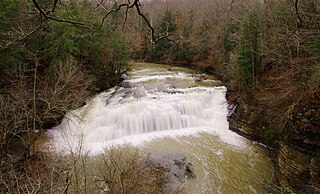
The Falling Water River is a 46.8-mile-long (75.3 km) stream in the east-central portion of Middle Tennessee in the United States. It rises just west of Monterey at the edge of the Cumberland Plateau, and traverses the Eastern Highland Rim before dropping off to the Nashville Basin and emptying into Center Hill Lake along the Caney Fork. The river is noted for the 136-foot (41 m) Burgess Falls, which it spills over near the end of its course.

<span class="mw-page-title-main">Stones River</span> River in the United States

The Stones River is a major stream of the eastern portion of Tennessee's Nashville Basin region and a tributary of the Cumberland River. It is named after explorer and longhunter Uriah Stone, who navigated the river in 1767.

<span class="mw-page-title-main">Sequatchie River</span> River in Tennessee, United States

The Sequatchie River is a 116-mile-long (187 km) waterway that drains the Sequatchie Valley, a large valley in the Cumberland Plateau in Tennessee. It empties into the Tennessee River downstream from Chattanooga near the Tennessee-Alabama state line.

<span class="mw-page-title-main">Big South Fork of the Cumberland River</span> River in the United States

The Big South Fork of the Cumberland River is a 76-mile-long (122 km) river in the U.S. states of Tennessee and Kentucky. It is a major drainage feature of the Cumberland Plateau, a major tributary of the Cumberland River system, and the major feature of the Big South Fork National River and Recreation Area.

<span class="mw-page-title-main">Nolichucky River</span> River in the Eastern United States

The Nolichucky River is a 115-mile (185 km) river that flows through western North Carolina and East Tennessee in the southeastern United States. Traversing the Pisgah National Forest and the Cherokee National Forest in the Blue Ridge Mountains, the river's watershed includes some of the highest mountains in the Appalachians, including Mount Mitchell in North Carolina, the highest point in the eastern United States. The river is a tributary of the French Broad River and is impounded by Nolichucky Dam near Greeneville, Tennessee.

<span class="mw-page-title-main">Fall Creek Falls State Park</span> State park in Tennessee, United States

Fall Creek Falls State Resort Park is a state park in Van Buren and Bledsoe counties, in the U.S. state of Tennessee. The over 30,638-acre (123.99 km2) park is centered on the upper Cane Creek Gorge, an area known for its unique geological formations and scenic waterfalls. The park's namesake is the 256-foot (78 m) Fall Creek Falls, the highest free-fall waterfall east of the Mississippi River.

<span class="mw-page-title-main">Burgess Falls State Park</span> Protected area in Tennessee, US

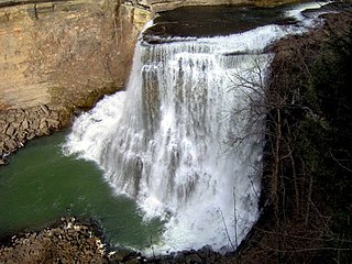
Burgess Falls State Park is a state park and state natural area in Putnam County and White County, Tennessee, located in the southeastern United States. The park is situated around a steep gorge in which the Falling Water River drops 250 feet (76 m) in elevation in less than a mile, culminating in a 136-foot (41 m) cataract waterfall.

<span class="mw-page-title-main">Rock Island State Park (Tennessee)</span> Park in Warren and White Counties, Tennessee, United States

Rock Island State Park is a state park in Warren County and White County, Tennessee, located in the Southeastern United States. The park is named after the community of Rock Island, Tennessee, which in turn received its name from an island on the Caney Fork upstream from the Collins River confluence and Great Falls Dam. Rock Island State Park is centered on a peninsula created by the confluence of these two rivers and extends downstream to the headwaters of Center Hill Lake.

<span class="mw-page-title-main">Edgar Evins State Park</span> State park in Tennessee, United States

Edgar Evins State Park is a state park in DeKalb County, Tennessee, in the southeastern United States. The park consists of 6,300 acres (25 km2) along the shores of Center Hill Lake, an impoundment of the Caney Fork. The State of Tennessee leases the land from the U.S. Army Corps of Engineers.

<span class="mw-page-title-main">Great Falls Dam (Tennessee)</span> Hydroelectric dam in Tennessee

Great Falls Dam is a hydroelectric dam on the Caney Fork, straddling the county line between White County and Warren County in the U.S. state of Tennessee. It is the only dam outside the Tennessee River watershed owned and operated by the Tennessee Valley Authority. The dam impounds the 1,830-acre (740 ha) Great Falls Lake, and its tailwaters feed into Center Hill Lake. The completion of Great Falls Dam in late 1916 was an engineering triumph, marking the first successful attempt to impound the volatile and flood-prone Caney Fork. The dam is also notable for its design, utilizing a mostly underground conduit to carry water from the reservoir via a tributary to the Power House 0.75 miles (1.21 km) downstream from the dam.

<span class="mw-page-title-main">Crooked River (Oregon)</span> River in Oregon, United States

The Crooked River is a tributary, 125 miles (201 km) long, of the Deschutes River in the U.S. state of Oregon. The river begins at the confluence of the South Fork Crooked River and Beaver Creek. Of the two tributaries, the South Fork Crooked River is the larger and is sometimes considered part of the Crooked River proper. A variant name of the South Fork Crooked River is simply "Crooked River". The Deschutes River flows north into the Columbia River.

<span class="mw-page-title-main">Scott's Gulf</span> Canyon in Tennessee

Scott's Gulf is a canyon situated along the Caney Fork River in White County, Tennessee, in the southeastern United States. The canyon stretches for approximately 18 miles (29 km) as the Caney Fork drops from the top of the Cumberland Plateau down to the eastern Highland Rim. This remote section of the river is home to a wilderness area consisting of a largely undisturbed deciduous forest, numerous waterfalls, caves and other geological formations, and Class IV and Class V whitewater rapids.

References

  1. 1 2 3 U.S. Geological Survey Geographic Names Information System: Caney Fork
  2. U.S. Geological Survey. Campbell Junction, TN. 1:24,000.
  3. U.S. Geological Survey. National Hydrography Dataset high-resolution flowline data. The National Map Archived 2012-03-29 at the Wayback Machine , accessed June 8, 2011.
  4. 1 2 Tennessee Division of Water Pollution Control, Caney Fork River Water Quality Management Plan Summary, October 2003, p. 1.
  5. Station 03422500 located approximately 0.8 miles downstream from Great Falls Dam
  6. 1 2 3 4 United States Geological Survey, Water Resources Data Tennessee: Water Year 1983, Water Data Report TN-83-1, p. 75.
  7. U.S. Geological Survey Geographic Names Information System: Caney Fork River
  8. Samuel Cole Williams, Early Travels in the Tennessee Country, 1540-1800 (Watauga Press, 1928), p. 419.