Related Research Articles

Howard County is a county located in the U.S. state of Arkansas. As of the 2020 census, the population was 12,785. The county seat is Nashville. Howard County is Arkansas's 74th county, formed on April 17, 1873, and named for James Howard, a state senator. It is a dry county.
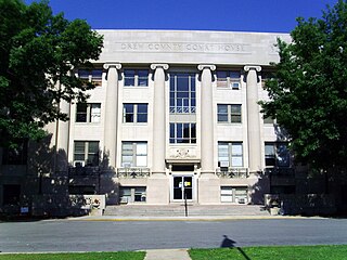
Drew County is a county located in the southeast region of the U.S. state of Arkansas. As of the 2020 census, the population was 17,350. The county seat and largest city is Monticello. Drew County was formed on November 26, 1846, and named for Thomas Drew, the third governor of Arkansas.

Arkansas County is a county located in the U.S. state of Arkansas. As of the 2020 census, the population was 17,149. Located in the Arkansas Delta, the county has two county seats, DeWitt and Stuttgart.

Batesville is the county seat and largest city of Independence County, Arkansas, United States, 80 miles (183 km) northeast of Little Rock, the state capital. According to the 2010 Census, the population of the city was 10,268. The city serves as a regional manufacturing and distribution hub for the Ozark Mountain region and Northeast Arkansas.

Carlisle is a city in Lonoke County, Arkansas, United States. It is the easternmost municipality within the Little Rock–North Little Rock–Conway Metropolitan Statistical Area. Carlisle was incorporated in 1878. As of the 2010 census it had a population of 2,214.

Plaquemine is a city in and the parish seat of Iberville Parish, Louisiana, United States. It is part of the Baton Rouge metropolitan statistical area. At the 2010 United States census, the population was 7,119; the 2020 census determined its population was 6,269.
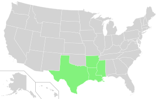
The Rice Belt of the United States includes Arkansas, Louisiana, Mississippi, and Texas, four southern U.S. states that grow a significant portion of the nation's rice crop. The name is in conformity with the Corn Belt of the Midwestern United States, in which much of the nation's corn is grown.

Bayou des Arc is a 74-mile-long (119 km) river in Arkansas, United States of America. It is a tributary of the White River, into which it flows near the city of Des Arc in Prairie County, Arkansas. It rises in northwest White County, Arkansas, near the town of Rose Bud.
Border irregularities of the United States, particularly panhandles and highway incursions into other jurisdictions, are shown here. Often they are a result of borders which do not conform to geological features such as changes in the course of a river that previously marked a border.
Bayou Bartholomew is the longest bayou in the world, meandering approximately 364 miles (586 km) in the U.S. states of Arkansas and Louisiana.

Bayou Township is a township in Ashley County, Arkansas, United States. Its population was 55 at the 2010 United States Census, a decrease of 5.17 percent from 58 at the 2000 census.
References
34°16′12″N91°13′48″W / 34.2700°N 91.2300°W