Perry County is a county located in the U.S. state of Arkansas. Its population was 10,019 at the 2020 United States Census. The county seat is Perryville. The county was formed on December 18, 1840, and named for Commodore Oliver Hazard Perry, naval hero in the War of 1812. It is an alcohol prohibition or dry county.

The Fourche La Fave River is a tributary of the Arkansas River, approximately 151 miles (243 km) long, in western Arkansas in the United States. It drains part of the northern Ouachita Mountains west of Little Rock.
The Fourche River is a tributary of the Black River in Northeast Arkansas and ending in Randolph County, Arkansas near Pocahontas at its confluence with the Black River. The source is the confluence of Fourche Creek and the west Fork of the Fourche Creek in Ripley County, Missouri. The Fourche River flows for 32.4 miles (52.1 km) in Missouri and Arkansas.

Arkansas Highway 60 is a state highway that exists in five separate sections in Arkansas. The longest and most well-known segment of 54.19 miles (87.21 km) runs from Highway 28 in Plainview east to U.S. Route 65B (US 65B) in Conway. A segment in western Logan County of 2.64 miles (4.25 km) begins at the Old Highway 10 at the Sebastian County line and runs east to Highway 10. A third segment of 10.80 miles (17.38 km) begins at Highway 252 near Lavaca and runs east to Highway 41 at Peter Pender. A fourth segment runs 1.34 miles (2.16 km) from US 64 and runs across Interstate 40/Interstate 540 (I-40/I-540) to Highway 282. A fifth route of 2.34 miles (3.77 km) begins at Highway 282 near Rudy and runs north to County Road 23 (CR 23).
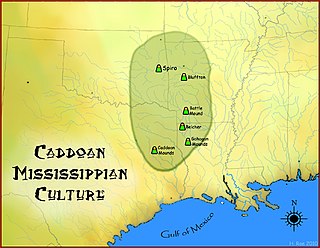
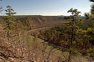
The Bluffton Mound Site is a Caddoan Mississippian culture archaeological site in Yell County, Arkansas on the Fourche La Fave River.

Arkansas Highway 314 is an east–west state highway in Perry and Yell Counties. The route runs 17.45 miles (28.08 km) as a connector between Arkansas Highway 27 and Arkansas Highway 7 in the Ouachita National Forest. The route does not intersect any other state highways.
Onyx is an unincorporated community in southern Yell County, Arkansas, United States. It is located at the intersection of Arkansas highways 314 and 27. The South Fourche La Fave River flows past south of the community.
The Flatside Wilderness is a 9,507-acre protected area in the U.S. state of Arkansas. It is one of six wilderness areas in the Ouachita National Forest and also the easternmost. Outdoor enthusiasts can enjoy the area in a number of ways, including an 8.9-mile section of the Ouachita National Recreation Trail.

The South Fourche LaFave River Bridge is a historic bridge in rural western Perry County, Arkansas. It is a two-span Parker pony truss bridge, carrying Arkansas Highway 7 across the South Fourche La Fave River, roughly midway between Ola and Jessieville in the eastern reaches of Ouachita National Forest. The bridge was built in 1933, and has a total length of 485 feet (148 m), each of its main spans measuring 102 feet (31 m).

The Hollis Country Store is a historic general store on Arkansas Highway 7 in rural Perry County, Arkansas. It is located on the west side of AR 7 in the Ouachita National Forest, a short way north of the South Fourche LaFave River Bridge. In addition to the store, the property includes a picnic shelter and two tourist cabins. The core of the store is a stone structure built in 1931–32, with most of the other parts added in the 1950s. It is an excellent example of vernacular roadside architecture from the period.

The Fourche LaFave River Bridge carries Arkansas Highway 7 across the Fourche LaFave River in western Perry County, Arkansas, downstream of the Nimrod Dam. It is a three-span open spandrel concrete arch bridge, with its longest span measuring 184 feet (56 m), and its total length 518 feet (158 m). The arches are mounted on concrete abutments and piers. The bridge deck is asphalt, and is lined by ornate concrete balustrades. It was built in 1941 by the Luten Bridge Company, and is a well-preserved example of style from that period.
Nimrod is an unincorporated community in Perry County, Arkansas, United States. The community is located along Arkansas Highway 60, 16 miles (26 km) west-southwest of Perryville.
Ava is an unincorporated community in Perry County, Arkansas, United States. The community is 25 miles (40 km) west-southwest of Perryville. It is located on the south side of the South Fourche La Fave River floodplain and Arkansas Highway 314 passes on the north side of the river.
Hollis is an unincorporated community in Perry County, Arkansas, United States. The community is located at the junction of Arkansas Highway 7 and Arkansas Highway 314, 20 miles (32 km) west-southwest of Perryville.
Fourche Junction is an unincorporated community in Perry County, Arkansas, United States. The community is located at the junction of Arkansas Highway 7 and Arkansas Highway 60 along the Fourche La Fave River, near the Nimrod Dam and 20.5 miles (33.0 km) west of Perryville.
Crooked Creek is a stream in Newton, Boone and Marion counties of north Arkansas. It is a tributary of the White River.
Piney Creek is a stream in southern Carroll County of the U.S. state of Arkansas. It is a tributary to the Kings River.
Osage Creek is a stream in Newton, Boone, and Carroll counties of northern Arkansas. It is a tributary of the Kings River.