Arkansas is a landlocked state in the South Central region of the Southern United States. It borders Missouri to the north, Tennessee and Mississippi to the east, Louisiana to the south, Texas to the southwest, and Oklahoma to the west. Its name derives from the Osage language, and refers to their relatives, the Quapaw people. The state's diverse geography ranges from the mountainous regions of the Ozark and Ouachita Mountains, which make up the U.S. Interior Highlands, to the densely forested land in the south known as the Arkansas Timberlands, to the eastern lowlands along the Mississippi River and the Arkansas Delta.

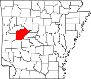
Yell County is a county in the U.S. state of Arkansas. As of the 2020 census, the population was 20,263. The county has two county seats, Dardanelle and Danville. Yell County is Arkansas's 42nd county, formed on December 5, 1840, from portions of Scott and Pope counties. It was named after Archibald Yell, who was the state's first member of the United States House of Representatives and the second governor of Arkansas. He died in combat at the Battle of Buena Vista during the Mexican–American War.

Marion is a city in and the county seat of Crittenden County, Arkansas, United States. The population was 12,345 at the 2010 census, a 38.7% increase since 2000. The city is part of the Memphis metropolitan area. It is the second largest city in Crittenden County, behind West Memphis.

El Dorado is a city in, and the county seat of, Union County, on the southern border of Arkansas, United States. According to the 2020 census, the population of the city is 17,755.

Fayetteville is the second-most populous city in the U.S. state of Arkansas, the county seat of Washington County, and the most populous city in Northwest Arkansas. The city had a population of 93,949 as of the 2020 census, which was estimated to have increased to 101,680 by 2023. The city is on the outskirts of the Boston Mountains, deep within the Ozarks. It was named after Fayetteville, Tennessee, from which many settlers had come, and was incorporated on November 3, 1836. Fayetteville is included in the three-county Fayetteville–Springdale–Rogers metropolitan statistical area, with 576,403 residents in 2020.

Onyx is a census-designated place (CDP) in Kern County, California, United States. Onyx is located 3.5 miles (6 km) east-northeast of Weldon in the South Fork Valley at an elevation of 2,795 feet (852 m). The population was 475 at the 2010 census, down from 476 at the 2000 census.

The Ozarks, also known as the Ozark Mountains, Ozark Highlands or Ozark Plateau, is a physiographic region in the U.S. states of Missouri, Arkansas, Oklahoma and the extreme southeastern corner of Kansas. The Ozarks cover a significant portion of northern Arkansas and most of the southern half of Missouri, extending from Interstate 40 in central Arkansas to Interstate 70 in central Missouri.

The Boston Mountains is a Level III ecoregion designated by the Environmental Protection Agency (EPA) in the U.S. states of Arkansas and Oklahoma. Part of the Ozarks, the Boston Mountains are a deeply dissected plateau. The ecoregion is steeper than the adjacent Springfield Plateau to the north, and bordered on the south by the Arkansas Valley. The Oklahoma portion of the range is locally referred to as the Cookson Hills. There are several theories of how the mountains were named, though apparently none are related to the Massachusetts city.

Onyx is the parallel-banded variety of chalcedony, a silicate mineral. Agate and onyx are both varieties of layered chalcedony that differ only in the form of the bands. Onyx has parallel bands while agate has curved bands. The colors of its bands range from black to almost every color. Specimens of onyx commonly contain bands of black or white, or both. Onyx, as a descriptive term, has also been applied to parallel-banded varieties of alabaster, marble, calcite, obsidian, and opal, and misleadingly to materials with contorted banding, such as "cave onyx" and "Mexican onyx".

Onyx is an American hardcore hip hop group from South Jamaica, Queens, New York City, formed in 1988 by Fredro Starr, Suavé and the late Big DS. Sticky Fingaz joined the group in 1991.
Onyx is a banded variety of chalcedony (quartz).

Arkansas State University Mid-South, formerly Mid-South Community College (MSCC), is a public community college in West Memphis, Arkansas. ASU Mid-South offers degree programs, technical courses, community educational offerings, and intercollegiate athletics.

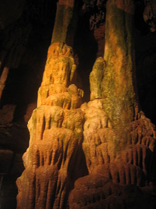
Onyx Cave is a small show cave located about 6 miles (9.7 km) east of Eureka Springs, Arkansas. It has been a tourist attraction since 1893, making it the oldest show cave in Arkansas. The cave does not contain onyx, but rather flowstone, also known as "cave onyx". During the 19th century and the beginning of the 20th century many such caves were named similarly.
Onyx Cave may refer to several things in the United States:

Little Rock is the capital and most populous city of the U.S. state of Arkansas. The city's population was 202,591 as of the 2020 census. The six-county Little Rock metropolitan area is the 81st-most populous in the United States with 748,031 residents according to the 2020 census.

Canebrake is an unincorporated community in Kern County, California. It is located along California State Route 178 in the South Fork Valley, 5.3 miles (9 km) east-northeast of Onyx at an elevation of 3,031 feet (924 m).
Lost Corner is an unincorporated community in Pope County, Arkansas, United States. The community changed its name from Okay to avoid confusion with a community in Howard County with the same name. Lost Corner was selected because of the backwoods location of the community.

Arkansas Highway 314 is an east–west state highway in Perry and Yell Counties. The route runs 17.45 miles (28.08 km) as a connector between Arkansas Highway 27 and Arkansas Highway 7 in the Ouachita National Forest. The route does not intersect any other state highways.

Northwest Arkansas (NWA) is a metropolitan area and region in Arkansas within the Ozark Mountains. It includes four of the ten largest cities in the state: Fayetteville, Springdale, Rogers, and Bentonville, the surrounding towns of Benton and Washington counties, and adjacent rural Madison County, Arkansas. The United States Census Bureau-defined Fayetteville–Springdale–Rogers Metropolitan Statistical Area includes 3,213.01 square miles (8,321.7 km2) and 590,337 residents, ranking NWA as the 98th most-populous metropolitan statistical area in the U.S. and the 13th fastest growing in the United States.

The South Fourche La Fave River is a stream in the Ouachita Mountains of Perry and Yell counties of Arkansas. It is a tributary of the Fourche La Fave River.


