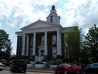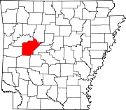
Yell County is a county in the U.S. state of Arkansas. As of the 2020 census, the population was 20,263. The county has two county seats, Dardanelle and Danville. Yell County is Arkansas's 42nd county, formed on December 5, 1840, from portions of Scott and Pope counties. It was named after Archibald Yell, who was the state's first member of the United States House of Representatives and the second governor of Arkansas. He died in combat at the Battle of Buena Vista during the Mexican–American War.

Logan County is a county located in the U.S. state of Arkansas. As of the 2020 census, the population was 21,131. Its two county seats are Booneville and Paris.

Highway 7 is a north–south state highway that runs across the state of Arkansas. As Arkansas's longest state highway, the route runs 297.27 miles (478.41 km) from Louisiana Highway 558 at the Louisiana state line north to Bull Shoals Lake at Diamond City near the Missouri state line. With the exception of the segment north of Harrison, Highway 7 has been designated as an Arkansas Scenic Byway and a National Forest Scenic Byway. The road passes through the heart of both the Ozark Mountains and the Ouachita Mountains, and features scenic views. It's the route favored by motorcycle riders touring the region.

Highway 22 is an east–west state highway in the Arkansas River Valley. It is maintained by the Arkansas State Highway and Transportation Department (AHTD). The highway runs 75.60 miles (121.67 km) from US 64/US 71B east to Highway 7 in Dardanelle. Following the historic stagecoach line of the cross-country Butterfield Trail, the highway is one of the original 1926 state highways. It is designated by the AHTD as the True Grit Trail.

Arkansas Highway 10 is an east–west state highway in West Arkansas. The route runs 135.41 miles (217.92 km) from Oklahoma State Highway 120 near Hackett east to Interstate 30 in Little Rock, the state's capitol. The highway serves both the Fort Smith metropolitan area and the Little Rock – North Little Rock – Conway metropolitan area.
Two Rivers School District No. 10 is a public school district in Yell, Perry, and Conway counties, Arkansas, United States. Two Rivers, headquartered in an unincorporated area in Yell County near Ola, consists of two schools including Two Rivers Elementary and Two Rivers High; it previously operated Ola Elementary School/Ola High School, the Fourche Valley School, and Plainview–Rover Elementary School/Plainview–Rover High School.

Arkansas Highway 60 is a state highway that exists in five separate sections in Arkansas. The longest and most well-known segment of 54.19 miles (87.21 km) runs from Highway 28 in Plainview east to U.S. Route 65B (US 65B) in Conway. A segment in western Logan County of 2.64 miles (4.25 km) begins at the Old Highway 10 at the Sebastian County line and runs east to Highway 10. A third segment of 10.80 miles (17.38 km) begins at Highway 252 near Lavaca and runs east to Highway 41 at Peter Pender. A fourth segment runs 1.34 miles (2.16 km) from US 64 and runs across Interstate 40/Interstate 540 (I-40/I-540) to Highway 282. A fifth route of 2.34 miles (3.77 km) begins at Highway 282 near Rudy and runs north to County Road 23 (CR 23).

Highway 28 is designation for three east–west state highways in Western Arkansas. Two segments together running from the Oklahoma state line to Ola have been established since the original 1926 Arkansas state highway numbering, with the third segment designated in 1963. All three highways are rural, two-lane roads with relatively low traffic serving a sparsely populated and forested part of Arkansas. The highways are maintained by the Arkansas Department of Transportation (ARDOT).

Arkansas Highway 309 is a designation for two state highways in Western Arkansas. One route of 5.11 miles (8.22 km) runs from Yell County Route 28 (CR 28) at Blue Mountain Lake northeast to Highway 10 at Waveland. A second segment begins at Highway 10 in Havana and winds northwest through the Ozark National Forest to Highway 23 at Webb City via Paris. A portion of the second route is designated as the Mount Magazine Scenic Byway, one of eleven Arkansas Scenic Byways maintained by the Arkansas State Highway and Transportation Department (AHTD).

Arkansas Highway 314 is an east–west state highway in Perry and Yell Counties. The route runs 17.45 miles (28.08 km) as a connector between Arkansas Highway 27 and Arkansas Highway 7 in the Ouachita National Forest. The route does not intersect any other state highways.
Bluffton is an unincorporated community in Yell County, Arkansas, United States, located on Arkansas Highway 28, 18 miles (29 km) west-southwest of Plainview. Bluffton has a post office with ZIP code 72827.
Gravelly is an unincorporated community in Yell County, Arkansas, United States, located on Arkansas Highway 28, 23 miles (37 km) west-southwest of Plainview. Gravelly has a post office with ZIP code 72838.

Arkansas Highway 155 is a designation for four state highways in Arkansas. The northernmost segment of 7.10 miles (11.43 km) runs from Mount Nebo State Park to AR 22 in Dardanelle. A second segment in Yell County of 7.56 miles (12.17 km) connects Highway 7 and Highway 154. A third segment runs 11.16 miles (17.96 km) from AR 10 near Casa to Petit Jean State Park. The fourth segment is a 2.68-mile (4.31 km) spur from Highway 60 south to an area near Deberrie.
Aly is an unincorporated community in Yell County, Arkansas, United States, located on Arkansas Highway 27, 19 miles (31 km) south-southwest of Danville.

Arkansas Highway 154 is a 41.00-mile (65.98 km) east-west state highway in the western portion of the U.S. state of Arkansas. The highway begins at Arkansas Highway 27 in Yell County northeast of Danville and runs east to Arkansas Highway 113 in Conway County east of Oppelo. Highway 154 is maintained by the Arkansas State Highway and Transportation Department.
Mount George is an unincorporated community in Yell County, Arkansas, United States, located at the junction of Arkansas Highways 28 and 154, 9 miles (14 km) south-southwest of Dardanelle.
Pleasant Hill is an unincorporated community in Yell County, Arkansas, United States, located on Arkansas Highway 307, 14 miles (23 km) southwest of Danville.
Fourche Valley School District #13 was a school district headquartered in unincorporated Yell County, Arkansas, near Briggsville. Fourche Valley School or FVS was its school, with the mascot being the Indians.

Highway 80 is an east–west state highway in the Ouachita Mountains. The route of 49.87 miles (80.26 km) begins at AR 28 at Hon and runs east to AR 27 in Danville. The route is maintained by the Arkansas Department of Transportation (ArDOT).
Ard is an unincorporated community in Yell County, Arkansas, United States. The community is located along locally maintained Ard Road 5.7 miles (9.2 km) south-southwest of Dardanelle.


