
Russellville is the county seat and largest city in Pope County, Arkansas, United States, with a 2021 estimated population of 29,338. It is home to Arkansas Tech University. Arkansas Nuclear One, Arkansas' only nuclear power plant is nearby. Russellville borders Lake Dardanelle and the Arkansas River.

Dardanelle is a city in northeast Yell County, Arkansas, United States. The population was 4,745 at the 2010 census. Along with Danville, it serves as a county seat for Yell County. It is located near Lake Dardanelle.
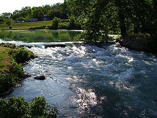
Mammoth Spring State Park is a 62.5-acre (25.3 ha) Arkansas state park in Fulton County, Arkansas in the United States. The park is located surrounding National Natural Landmark of the same name to provide recreation and interpretation for visitors. The park offers fishing, boating and hiking in addition to an Arkansas Welcome Center and restored 1886 St. Louis–San Francisco Railway (Frisco) depot operating as a railroad museum. The site became a state park in 1957, but the park continued to add area until 1975.

Petit Jean State Park is a 3,471-acre (1,405 ha) park in Conway County, Arkansas managed by the Arkansas Department of Parks and Tourism. It is located atop Petit Jean Mountain adjacent to the Arkansas River in the area between the Ouachita Mountains and Ozark Plateaus.
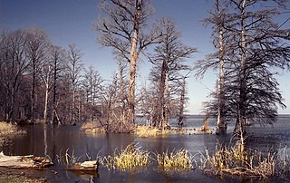
Reelfoot Lake State Park is a state park in the northwest corner of Tennessee in the United States. It encompasses Reelfoot Lake and is situated in Lake and Obion counties. The park itself makes up 280 acres (1.1 km2), divided into ten sections around the lake. A major hunting and fishing preserve, it is part of a much larger wildlife refuge which comprises 25,000 acres (100 km2), 15,000 acres (61 km2) of which are water, and harbors almost every kind of shorebird, as well as the golden and American bald eagles. Other animals are also diverse and abundant. The many species of flowering and non-flowering plants attract botany enthusiasts from all over the country. Baldcypress dominates the margins of the lake, but many other trees and shrubs are also present.
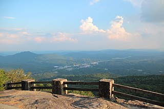
Black Rock Mountain State Park is a 1,743-acre (705 ha) Georgia, United States, state park west of Mountain City in Rabun County, in the Blue Ridge Mountains. It is named after its sheer cliffs of dark-colored biotite gneiss. Astride the Eastern Continental Divide at an elevation of 3,640 feet (1,110 m), the park provides many scenic overlooks and 80-mile (130 km) vistas of the southern Appalachian Mountains. On a clear day, four states are visible: Georgia, North Carolina, South Carolina, and Tennessee. In addition to Black Rock Mountain itself, the park includes four other peaks over 3,000 feet (910 m) in elevation, making it the state's highest state park. As of 2019, it was open to visitors year round.

Lake Chicot State Park is a 211.6 acres (85.6 ha) Arkansas state park in Chicot County, Arkansas within the Arkansas delta. The park is located along Lake Chicot, a 22 miles (35 km) oxbow lake that was formerly the main channel of the Mississippi River. The lake, formerly a polluted eyesore for the area, has been restored to its current condition through the cooperation of many agencies to return its natural, cultural and recreational value. As the state's largest natural lake and the largest oxbow lake in the United States, Lake Chicot State Park features unique fishing and camping opportunities among large cypress trees, creating a bayou environment for both wildlife and visitors.

DeGray Lake is a reservoir on the Caddo River constructed by the United States Army Corps of Engineers in Arkansas, 8 miles (13 km) from Arkadelphia. Arkansas Scenic Byway 7 is located on the eastern shore of the lake, and provides views of the lake, and also places to stay. DeGray Lake Resort State Park was opened in 1974 to encourage tourism and recreation on DeGray Lake.

Lake Dardanelle is a major reservoir on the Arkansas River in Arkansas, USA. and is an integral part of the McClellan-Kerr Arkansas River Navigation System (MKARNS), which allows barge transportation from the Mississippi River to the Tulsa Port of Catoosa in northeastern Oklahoma. MKARNS went into service along its full length in 1971.
DeGray Lake Resort State Park is a 984-acre (398 ha) Arkansas state park in Clark and Hot Spring counties, Arkansas in the United States. Situated in the Ouachita Mountains, the park features the 13,800-acre (5,600 ha) DeGray Lake, the park features a championship rated 18 hole golf course and Arkansas's only state park resort. The United States Army Corps of Engineers began constructing DeGray Dam on the Caddo River in 1963, and support for a state park began growing shortly after. The park was created in 1974, and the resort and golf course were added by 1975.
Located near Dardanelle, Arkansas and rising about 1,350 feet (410 m) above the mountain valleys of west-central Arkansas to an elevation of about 1,755 feet (535 m) above sea level, Mount Nebo has views of 34,000 acres (140 km2) Lake Dardanelle, the Arkansas River and the surrounding mountain ridges. Atop this biblically named plateau is Mount Nebo State Park. Developed as a resort area in the late 19th century, it became a state park in 1928, its early development spearheaded by the Civilian Conservation Corps. Park activities include hiking, camping, and other outdoor pursuits.

Hugo Lake is manmade lake located 7 miles (11 km) east of Hugo, in Choctaw County, Oklahoma, United States. It is formed by Hugo Lake Dam on the Kiamichi River 18 miles (29 km) upstream from the Red River. The dam is visible from U.S. Route 70, which crosses its spillway just west of Sawyer. Lake Hugo features approximately 110 miles (180 km) of shoreline and covers over 13,250 acres (53.6 km2), or 20 square miles (52 km2). Its normal pool elevation is 404.5 feet (123.3 m) above sea level and its normal storage capacity is 157,600 acre-feet (194,400,000 m3). At flood stage its elevation is at 437.5 feet (133.4 m) above sea level and it is capable of storing 966,700 acre-feet (1.1924×10⁹ m3) of flood waters. The lake's primary functions are to provide flood control, water storage, and recreational opportunities.
Illinois Township is one of nineteen current townships in Pope County, Arkansas, USA. As of the 2010 census, its total population was 29,813, with 91.8 percent contained in urban Russellville.

Norristown was a 19th-century town and trading center on the Arkansas River and, later, an incorporated town on Norristown Mountain in Illinois Township, Pope County, Arkansas, United States. The town merged with Russellville on August 14, 1980.
Shiloh is a populated area that lies partly in Russellville and partly in unincorporated Pope County, Arkansas, United States. It is located between Interstate 40 and Dover on Arkansas Highway 7.

The Arkansas River Valley is a region in Arkansas defined by the Arkansas River in the western part of the state. Generally defined as the area between the Ozark and Ouachita Mountains, the River Valley is characterized by flat lowlands covered in fertile farmland and lakes periodically interrupted by high peaks. Mount Magazine, Mount Nebo, and Petit Jean Mountain compose the Tri-Peaks Region, a further subdivision of the River Valley popular with hikers and outdoors enthusiasts. In addition to the outdoor recreational activities available to residents and visitors of the region, the River Valley contains Arkansas's wine country as well as hundreds of historical sites throughout the area. It is one of six natural divisions of Arkansas.
Piney Run Park is a nature park in Sykesville, located in Carroll County, Maryland. It is Carroll County's oldest developed park and hosts thousands of visitors annually. The park encompasses 550 acres of fields, forest and open spaces, features over 15 miles of hiking trails, a 300-acre lake and many sports and recreational facilities. Prior to being a park, this land was a private farm.

Mount Magazine State Park is a 2,234-acre park located in Logan County, Arkansas. Inhabited since the 1850s, Mount Magazine first became part of the Ouachita National Forest in 1938, was re-designated as part of the Ozark National Forest in 1941, and became a state park after a 22-year conversion process from the U.S. Forest Service to the Arkansas Department of Parks and Tourism. Mount Magazine State Park is the highest in Arkansas. The park contains Mossback Ridge, including the peak of Mount Magazine which contains The Lodge at Mount Magazine, cabins, trails, and a hang gliding area.
Big Break Regional Shoreline is a regional park in Oakley, Contra Costa County, northern California. It is a part of the East Bay Regional Park District system.

Lake Frierson State Park is a 114-acre (46 ha) Arkansas state park on Crowley's Ridge in Greene County, eastern Arkansas.


