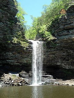
Petit Jean State Park is a 3,471-acre (1,405 ha) park in Conway County, Arkansas managed by the Arkansas Department of Parks and Tourism. It is located atop Petit Jean Mountain adjacent to the Arkansas River in the area between the Ouachita Mountains and Ozark Plateaus.

Bandelier National Monument is a 33,677-acre (13,629 ha) United States National Monument near Los Alamos in Sandoval and Los Alamos counties, New Mexico. The monument preserves the homes and territory of the Ancestral Puebloans of a later era in the Southwest. Most of the pueblo structures date to two eras, dating between 1150 and 1600 AD.

F.D. Roosevelt State Park is a 9,049 acres (36.62 km2) Georgia state park located near Pine Mountain and Warm Springs. The park is named for former U.S. President Franklin Delano Roosevelt, who sought a treatment for his paralytic illness in nearby Warm Springs at the Little White House. The park is located along the Pine Mountain Range. The western portion of the park, formerly named Pine Mountain State Park, was named a National Historic Landmark in 1997. F.D. Roosevelt State Park is Georgia's largest state park.

Fort Smith National Historic Site is a National Historic Site located in Fort Smith, Arkansas, along the Arkansas River. The first fort at this site was established by the United States in 1817, before this area was established as part of Indian Territory. It was later replaced and the second fort was operated by the US until 1871. This site was designated as a National Historic Landmark in 1961.

St. Croix State Park is a state park in Pine County, Minnesota, USA. The park follows the shore of the St. Croix River for 21 miles (34 km) and contains the last 7 miles (11 km) of the Kettle River. At 33,895 acres (13,717 ha) it is the largest Minnesota state park. It was developed as a Recreational Demonstration Area in the 1930s, and is one of the finest surviving properties of this type in the nation. 164 structures built by the Civilian Conservation Corps and the Works Progress Administration survive, the largest collection of New Deal projects in Minnesota. As a historic district they were listed on the National Register of Historic Places and proclaimed a National Historic Landmark in 1997.

Watoga State Park is a state park located near Seebert in Pocahontas County, West Virginia. The largest of West Virginia's state parks, it covers slightly over 10,100 acres (41 km2). Nearby parks include the Greenbrier River Trail, which is adjacent to the park, Beartown State Park, and Droop Mountain Battlefield State Park. Also immediately adjacent to the park is the 9,482-acre Calvin Price State Forest. It is one of the darkest night skies of all of West Virginia State Parks.

Kooser State Park is a 250-acre (101 ha) Pennsylvania state park in Jefferson Township, Somerset County, Pennsylvania, in the United States. The park, which borders Forbes State Forest, was built in the 1930s by the Civilian Conservation Corps, who also built the 4-acre (1.6 ha) Kooser Lake by damming Kooser Run. Kooser State Park is on Pennsylvania Route 31 a one-hour drive from Pittsburgh. The park is surrounded by Forbes State Forest.

Backbone State Park is Iowa's oldest state park, dedicated in 1919. Located in the valley of the Maquoketa River, it is approximately three miles (5 km) south of Strawberry Point in Delaware County. It is named for a narrow and steep ridge of bedrock carved by a loop of the Maquoketa River originally known as the Devil's Backbone. The initial 1,200 acres (490 ha) were donated by E.M. Carr of Lamont, Iowa. Backbone Lake Dam, a relatively low dam built by the Civilian Conservation Corps (CCC) in the 1930s, created Backbone Lake. The CCC constructed a majority of trails and buildings which make up the park.

Westmoreland State Park lies within Westmoreland County, Virginia. The park extends about one and a half miles along the Potomac River and covers 1,321 acres. The Horsehead Cliffs provide visitors with a panoramic view of the Potomac River, and lower levels feature fossils and beach access. The park offers hiking, camping, cabins, fishing, boating and swimming, although mechanical issues have kept the swimming pool closed since 2021. Located on the Northern Neck Peninsula, the park is close to historical sites featuring earlier eras: George Washington's birthplace and Stratford Hall, the birthplace of Robert E. Lee.

Copper Falls State Park is a 3,068-acre (1,242 ha) state park in Wisconsin. The park contains a section of the Bad River and its tributary the Tylers Forks, which flow through a gorge and drop over several waterfalls. Old Copper Culture Indians and later European settlers mined copper in the area. The state park was created in 1929 and amenities were developed by the Civilian Conservation Corps and the Works Progress Administration. In 2005 the park was listed on the National Register of Historic Places as a site with 10 contributing properties.
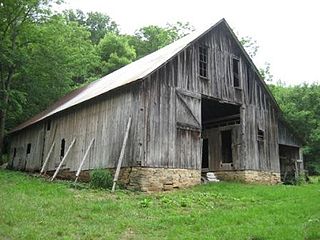
The Big Buffalo Valley Historic District, also known as the Boxley Valley Historic District, is notable as a cultural landscape in Buffalo National River. It comprises the Boxley Valley in northern Arkansas, near the town of Ponca. The valley includes a number of family-operated farms, primarily dating between 1870 and 1930. The farms are situated on either side of the road that parallels the river, Highway 43. Many of these farms are still operated by the descendants of the original homesteaders. However, of fifty residences in the valley, thirty were vacant in 1987, at the time of historic designation.

The Rush Historic District is a zinc mining region of the Ozark Mountains in Arkansas. Now located within Buffalo National River, the district includes ruins dating from 1880 to 1940. The area was an important part of what became known as the North Arkansas Lead and Zinc District, and played a role in the development of railroads and modern infrastructure in the area.
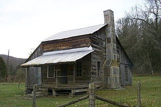
The Parker–Hickman Farm includes the oldest standing log structure in Buffalo National River. The farm was homesteaded in the 1840s by settlers from Tennessee. It embodies an agricultural landscape with farmstead, extant fields, fencerows, roads, cattle gates, garden and orchard plots, wooded slopes and springs. Unlike most farms in the Ozarks the landscape is remarkably intact and provides insights and evidence spanning portions of two centuries of Ozark history; not randomly chosen, it conveys a feeling of enclosure and exemplifies adaptive use of topography. Among farms of its kind in Missouri and Arkansas it was once typical but now survives as a rare baseline example for Ozark yeomanry farms of mixed economies. Parker–Hickman was an agricultural enterprise that continuously operated until 1982 from a farmstead which exemplifies the entire period, and a rare one for the Ozarks since it survives. Clustered around the farmstead are several structures: barns, sheds smokehouse, privy, fences, stock feeders and house that represent a cross-section of rural vernacular architecture still in their original location.

Devil's Den State Park is a 2,500-acre (1,000 ha) Arkansas state park in Washington County, near West Fork, Arkansas in the United States. The park was built by the Civilian Conservation Corps, beginning in 1933. Devil's Den State Park is in the Lee Creek Valley in the Boston Mountains, which are the southwestern part of The Ozarks. The park, with an 8 acres (3.2 ha) CCC-built lake, is open for year-round recreation, with trails for hiking, mountain biking and horseback riding. Devil's Den State Park also has several picnic areas, a swimming pool and cabins, with camping sites ranging from modern to primitive. Fossils of coral and crinoids can be found along the banks and within Lee Creek at Devil's Den State Park.

The historical buildings and structures of Zion National Park represent a variety of buildings, interpretive structures, signs and infrastructure associated with the National Park Service's operations in Zion National Park, Utah. Structures vary in size and scale from the Zion Lodge to road culverts and curbs, nearly all of which were designed using native materials and regional construction techniques in an adapted version of the National Park Service Rustic style. A number of the larger structures were designed by Gilbert Stanley Underwood, while many of the smaller structures were designed or coordinated with the National Park Service Branch of Plans and Designs. The bulk of the historic structures date to the 1920s and 1930s. Most of the structures of the 1930s were built using Civilian Conservation Corps labor.

The Mount Airy Forest, in Cincinnati, Ohio, was established in 1911. It was one of the earliest, if not the first, urban reforestation project in the United States. With nearly 1,500 acres (6.1 km2), it's the largest park in Cincinnati's park system.

The Wonderland Trail is an approximately 93-mile (150 km) hiking trail that circumnavigates Mount Rainier in Mount Rainier National Park, Washington, United States. The trail goes over many ridges of Mount Rainier for a cumulative 22,000 feet (6,700 m) of elevation gain. The trail was built in 1915.
Architects of the National Park Service are the architects and landscape architects who were employed by the National Park Service (NPS) starting in 1918 to design buildings, structures, roads, trails and other features in the United States National Parks. Many of their works are listed on the National Register of Historic Places, and a number have also been designated as National Historic Landmarks.

Petit Jean State Park is the oldest state park in Arkansas. It is located in the central northern part of the state, in western Conway County, atop Petit Jean Mountain, a ridge between the Ozark and Ouachita Mountains. One of the features the park is noted for is prehistoric rock art, some of which is accessible to park visitors via its hiking trails. A total of twelve such sites have been listed on the National Register of Historic Places for their importance. Most of the rock art has been dated to about 1500 CE, and is not obviously associated with habitation sites or other sites bearing evidence of other Native American activities.

Lacey-Keosauqua State Park is located southwest of Keosauqua, Iowa, United States. The park is located along the Des Moines River in Van Buren County. First dedicated in 1921, it is the largest state park in size in Iowa. In 1990, three areas were named nationally recognized historic districts and listed on the National Register of Historic Places.


