
Scouting in Arkansas has a long history, from 1913 to the present day, serving thousands of youth in programs that suit the environment in which they live.

The Ozarks, also known as the Ozark Mountains, Ozark Highlands or Ozark Plateau, is a physiographic region in the U.S. states of Missouri, Arkansas, Oklahoma and the extreme southeastern corner of Kansas. The Ozarks cover a significant portion of northern Arkansas and most of the southern half of Missouri, extending from Interstate 40 in central Arkansas to Interstate 70 in central Missouri.

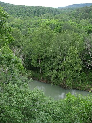
The Buffalo River, located in Northern Arkansas, was the first National River to be designated in the United States. The Buffalo River is 153 miles (246 km) long. The lower 135 miles (217 km) flow within the boundaries of an area managed by the National Park Service, where the stream is designated the Buffalo National River. The river flows through Newton, Searcy, Marion, and Baxter Counties, from west to east. The river originates in the highest part of the Boston Mountains of the Ozarks, flows out onto the Springfield Plateau near the historic community of Erbie, and finally crosses a portion of the Salem Plateau just before joining the White River. The Park is home to the state's only elk herd. The upper section of the river in the Ozark National Forest is managed by the U.S. Forest Service and is designated as a National Scenic River and a National Wild River; that section is not part of the area managed as a park by the Park Service but is managed as a part of the Ozark National Forest.
The Ozark – St. Francis National Forest is a United States National Forest that is located in the state of Arkansas. It is composed of two separate forests, Ozark National Forest in the Ozark Mountains; and St. Francis National Forest on Crowley's Ridge. Each forest has distinct biological, topographical, and geological differences.

Buffalo River State Park is a state park of Minnesota, United States, conserving a prairie bisected by the wooded banks of the Buffalo River. Together with the adjacent Bluestem Prairie Scientific and Natural Area co-owned by The Nature Conservancy and Minnesota's Department of Natural Resources, it protects one of the largest and highest-quality prairie remnants in Minnesota. It use to offer a man-made swimming pond close to the Fargo–Moorhead metropolitan area, however, that has not been open since 2018. Presently, it is most popular for its high quality educational programming, swimming in the Buffalo River, and picnicking. The 1,068-acre (432 ha) park is located just off U.S. Route 10 in Clay County, 4.5 miles (7.2 km) east of Glyndon and 14 miles (23 km) east of Moorhead.

Highway 21 is a north–south state highway in north central Arkansas. The route of 99.14 miles (159.55 km) runs from US Route 64 (US 64) in Clarksville north across US 62 to Missouri Route 13 at the Missouri state line The route is a two-lane highway with the exception of a brief concurrency with US 62, a four-lane highway, in Berryville.
The Buffalo River Trail is a hiking and backpacking trail that follows the path of the Buffalo National River in Arkansas. It consists of two separate sections that are referred to as the Western and Eastern sections. The Western Section is from Boxley Valley to Pruitt. The Eastern Section is from Woolum Ford to Highway 14. The Ozark Highlands Trail joins the Eastern Section of the Buffalo River Trail at Woolum Ford so it is officially designated the Buffalo River/Ozark Highlands Trail.

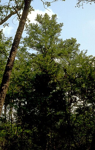
The geography of Arkansas varies widely. The state is covered by mountains, river valleys, forests, lakes, and bayous in addition to the cities of Arkansas. Hot Springs National Park features bubbling springs of hot water, formerly sought across the country for their healing properties. Crowley's Ridge is a geological anomaly rising above the surrounding lowlands of the Mississippi embayment.

Mormon Row is a historic district in Teton County, Wyoming, United States that is listed on the National Register of Historic Places.

The Snake River Land Company Residence and Office are structures associated with John D. Rockefeller Jr.'s acquisition of land in Jackson Hole, Wyoming, United States. Under the guise of the Snake River Land Company, Rockefeller bought much of the land that he eventually donated to the National Park Service, first as Jackson Hole National Monument and a year later as Grand Teton National Park. The buildings are located in the park, in the community of Moran. They served as the residence and office for SRLC vice president Harold Fabian and foreman J. Allan from 1930 to 1945. The buildings are still used by the National Park Service. The property was owned from 1926 to 1930 by John Hogan, a retired politician from the eastern United States. The Snake River Land Company bought the property in 1930.

The Buckner Homestead Historic District, near Stehekin, Washington in Lake Chelan National Recreation Area incorporates a group of structures relating to the theme of early settlement in the Lake Chelan area. Representing a time period of over six decades, from 1889 to the 1950s, the district comprises 15 buildings, landscape structures and ruins, and over 50 acres (200,000 m2) of land planted in orchard and criss-crossed by hand-dug irrigation ditches. The oldest building on the farm is a cabin built in 1889. The Buckner family bought the farm in 1910 and remained there until 1970, when the property was sold to the National Park Service. The Buckner Cabin was listed on the National Register of Historic Places in 1974. The rest of the Buckner farm became a historic district in 1989. Today, the National Park Service maintains the Buckner homestead and farm as an interpretive center to give visitors a glimpse at pioneer farm life in the Stehekin Valley.

Villines Mill, also known as Boxley Mill or Whiteley Mill, was originally built c. 1840 by Abner Casey in the Buffalo River valley, in what is now Buffalo National River. After becoming known as Whiteley Mill, the mill was at the center of a Civil War skirmish known as the Battle of Whiteley's Mill. The mill was rebuilt in 1870 and replaced with a larger mill, becoming known as Villines Mill after the new owner. After three generations of Villines, the mill closed in the 1960s. The mill is included in the Big Buffalo Valley Historic District.

Buffalo River State Park was an Arkansas state park, established in 1938, that was absorbed into Buffalo National River when the Federal park was established in 1972. The area is now known as Buffalo Point. The new state park was developed with Civilian Conservation Corps labor in 1939 with the construction of park structures to plans from the National Park Service Branch of Plans and Designs. The CCC structures now comprise a historic district on the National Register of Historic Places.

The Rush Historic District is a zinc mining region of the Ozark Mountains in Arkansas. Now located within Buffalo National River, the district includes ruins dating from 1880 to 1940. The area was an important part of what became known as the North Arkansas Lead and Zinc District, and played a role in the development of railroads and modern infrastructure in the area.
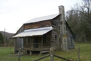
The Parker–Hickman Farm includes the oldest standing log structure in Buffalo National River. The farm was homesteaded in the 1840s by settlers from Tennessee. It embodies an agricultural landscape with farmstead, extant fields, fencerows, roads, cattle gates, garden and orchard plots, wooded slopes and springs. Unlike most farms in the Ozarks the landscape is remarkably intact and provides insights and evidence spanning portions of two centuries of Ozark history; not randomly chosen, it conveys a feeling of enclosure and exemplifies adaptive use of topography. Among farms of its kind in Missouri and Arkansas it was once typical but now survives as a rare baseline example for Ozark yeomanry farms of mixed economies. Parker–Hickman was an agricultural enterprise that continuously operated until 1982 from a farmstead which exemplifies the entire period, and a rare one for the Ozarks since it survives. Clustered around the farmstead are several structures: barns, sheds smokehouse, privy, fences, stock feeders and house that represent a cross-section of rural vernacular architecture still in their original location.

The historical buildings and structures of Zion National Park represent a variety of buildings, interpretive structures, signs and infrastructure associated with the National Park Service's operations in Zion National Park, Utah. Structures vary in size and scale from the Zion Lodge to road culverts and curbs, nearly all of which were designed using native materials and regional construction techniques in an adapted version of the National Park Service Rustic style. A number of the larger structures were designed by Gilbert Stanley Underwood, while many of the smaller structures were designed or coordinated with the National Park Service Branch of Plans and Designs. The bulk of the historic structures date to the 1920s and 1930s. Most of the structures of the 1930s were built using Civilian Conservation Corps labor.

The Buffalo Bill Cody Homestead is the boyhood home of Buffalo Bill Cody, a government scout and Wild West showman. The homestead is located in the broad valley of the Wapsipinicon River Valley south of McCausland, Iowa, United States, in rural Scott County. The farmhouse was built in 1847 by Isaac Cody, Buffalo Bill's father, of native limestone and contains walnut floors and trim.

The Arkansas River Valley is a region in Arkansas defined by the Arkansas River in the western part of the state. Generally defined as the area between the Ozark and Ouachita Mountains, the River Valley is characterized by flat lowlands covered in fertile farmland and lakes periodically interrupted by high peaks. Mount Magazine, Mount Nebo, and Petit Jean Mountain compose the Tri-Peaks Region, a further subdivision of the River Valley popular with hikers and outdoors enthusiasts. In addition to the outdoor recreational activities available to residents and visitors of the region, the River Valley contains Arkansas's wine country as well as hundreds of historical sites throughout the area. It is one of six natural divisions of Arkansas.

The historical buildings and structures of Grand Teton National Park include a variety of buildings and built remains that pre-date the establishment of Grand Teton National Park, together with facilities built by the National Park Service to serve park visitors. Many of these places and structures have been placed on the National Register of Historic Places. The pre-Park Service structures include homestead cabins from the earliest settlement of Jackson Hole, working ranches that once covered the valley floor, and dude ranches or guest ranches that catered to the tourist trade that grew up in the 1920s and 1930s, before the park was expanded to encompass nearly all of Jackson Hole. Many of these were incorporated into the park to serve as Park Service personnel housing, or were razed to restore the landscape to a natural appearance. Others continued to function as inholdings under a life estate in which their former owners could continue to use and occupy the property until their death. Other buildings, built in the mountains after the initial establishment of the park in 1929, or in the valley after the park was expanded in 1950, were built by the Park Service to serve park visitors, frequently employing the National Park Service Rustic style of design.
The Holzwarth Historic District comprises a series of cabins built by the Holzwarth family as a guest ranch inholding within the boundaries of Rocky Mountain National Park, at Grand Lake, Colorado. The Holzwarths made their homestead in the Kawuneeche Valley in 1917, two years after the establishment of the park, and received a patent on the homestead in 1923. Guest ranch use began in 1919 and continued until the ranch was purchased by The Nature Conservancy in 1974. The property was transferred to the National Park Service in 1975 for incorporation into the park. The district comprises a number of rustic cabins on the Colorado River. Operations existed on both sides of the river, first known as the Holzwarth Trout Ranch and later as the Never Summer Ranch. All but Joe Fleshut's cabin have been removed from the east side of the river.

