
Lewisburg is a borough in Union County, Pennsylvania, United States, 30 miles (48 km) south by southeast of Williamsport and 60 miles (97 km) north of Harrisburg. In the past, it was the commercial center for a fertile grain and general farming region. The population was 5,158 as of the 2020 census. It is the county seat of Union County. Located in central Pennsylvania's Susquehanna River Valley, on the West Branch Susquehanna River, Lewisburg is northwest of Sunbury. It is home to Bucknell University and is near the Lewisburg Federal Penitentiary. Its 19th-century downtown is on the National Register of Historic Places. Lewisburg is the principal city of the Lewisburg, PA Micropolitan Statistical Area, and is also part of the larger Bloomsburg-Berwick-Sunbury, PA Combined Statistical Area.

The Buffalo River, located in Northern Arkansas, was the first National River to be designated in the United States. The Buffalo River is 153 miles (246 km) long. The lower 135 miles (217 km) flow within the boundaries of an area managed by the National Park Service, where the stream is designated the Buffalo National River. The river flows through Newton, Searcy, Marion, and Baxter Counties, from west to east. The river originates in the highest part of the Boston Mountains of the Ozarks, flows out onto the Springfield Plateau near the historic community of Erbie, and finally crosses a portion of the Salem Plateau just before joining the White River. The Park is home to the state's only elk herd. The upper section of the river in the Ozark National Forest is managed by the U.S. Forest Service and is designated as a National Scenic River and a National Wild River; that section is not part of the area managed as a park by the Park Service but is managed as a part of the Ozark National Forest.
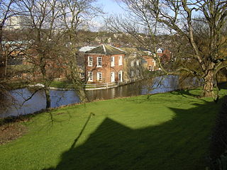
The Porter Brook is a river which flows through the City of Sheffield, England, descending over 1,000 feet (300 m) from its source on Burbage Moor to the west of the city to its mouth where it joins the River Sheaf in a culvert beneath Sheffield railway station. Like the other rivers in Sheffield, its steep gradient made it ideal for powering water mills and works associated with the metalworking and cutlery industries, and around 20 dams were constructed over the centuries to facilitate this. At its lower end, it is extensively culverted, but parts of it are gradually being restored to open channels, as part of a daylighting scheme for the city.

Brandywine Creek is a tributary of the Christina River in southeastern Pennsylvania and northern Delaware in the United States. The Lower Brandywine is 20.4 miles (32.8 km) long and is a designated Pennsylvania Scenic River with several tributary streams. The East Branch and West Branch of the creek originate within 2 miles (3 km) of each other on the slopes of Welsh Mountain in Honey Brook Township, Pennsylvania, about 20 miles (32 km) northwest of their confluence.
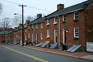
Oella is a mill town on the Patapsco River in western Baltimore County, Maryland, United States, located between Catonsville and Ellicott City. It is a 19th-century village of millworkers' homes.

This is a list of properties and historic districts in Oregon that are listed on the National Register of Historic Places. There are listings in all of Oregon's 36 counties.

This is a list of properties and historic districts in Iowa that are listed on the National Register of Historic Places. There are listings in all of Iowa's 99 counties, adding up to over 2,300 total.

Buildings, sites, districts, and objects in Virginia listed on the National Register of Historic Places:

This is a list of properties and districts listed on the National Register of Historic Places in Pennsylvania. As of 2015, there are over 3,000 listed sites in Pennsylvania. All 67 counties in Pennsylvania have listings on the National Register.

This is a list of properties and districts in Ohio that are listed on the National Register of Historic Places. There are over 4.000 in total. Of these, 73 are National Historic Landmarks. There are listings in each of Ohio's 88 counties.

The Slater Mill is a historic water-powered textile mill complex on the banks of the Blackstone River in Pawtucket, Rhode Island, modeled after cotton spinning mills first established in England. It is the first water-powered cotton spinning mill in America to utilize the Arkwright system of cotton spinning as developed by Richard Arkwright.
Sgt. Alvin C. York State Historic Park is a state park in Pall Mall, in the U.S. state of Tennessee. Situated along the Wolf River, the park contains the farm and gristmill once owned by decorated World War I soldier Alvin C. York (1887–1964), who lived in the Pall Mall area for his entire life. Along with the millhouse and milldam, the park includes York's two-story house, York's general store and post office, the Wolf River Cemetery, the Wolf River Methodist Church, the York Bible Institute, and various picnic facilities.

This is a list of the National Register of Historic Places listings in Dakota County, Minnesota. It is intended to be a complete list of the properties and districts on the National Register of Historic Places in Dakota County, Minnesota, United States. Dakota County is located in the southeastern part of the U.S. state of Minnesota, bounded on the northeast side by the Upper Mississippi River and on the northwest by the Minnesota River. The locations of National Register properties and districts for which the latitude and longitude coordinates are included below, may be seen in an online map.

Boyd's Windmill, also known as Boyd's Wind Grist Mill, is a historic smock mill at Paradise Valley Park on Prospect Avenue in Middletown, Rhode Island. John Peterson built the windmill at the corner of Mill Lane and West Main Rd. in Portsmouth, Rhode Island in 1810, and William Boyd purchased it in 1815. It originally had four common sails, but four more were added by the family. The mill is a timber-frame structure, octagonal in shape, and about 30 feet (9.1 m) tall, with a rotating cap powered by eight vanes with canvas sheets. The grindstones in the middle of the mill are Fall River granite; the upper one, which is connected to the power mechanisms, rotates six times for each turn of the mill's main shaft. In 1916 Benjamin Boyd removed the original vanes and powered the mill using a gasoline engine. It is one of only two historic windmills to survive on Aquidneck Island.
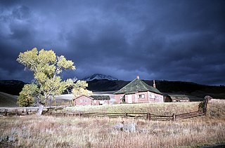
The Lamar Buffalo Ranch is a historic livestock ranch in the Lamar River valley of Yellowstone National Park, in the U.S. state of Wyoming. As an early contribution to the conservation of bison, it was created to preserve one of the last free-roaming American bison (buffalo) herds in the United States. The ranch was established in 1907 when 28 bison were moved from Fort Yellowstone to the Lamar Valley in the northeast corner of the park.

The Watts Mill Bridge is a pin-connected Pratt pony truss bridge located over the Little Beaver Creek in Cannelton, Pennsylvania, United States.
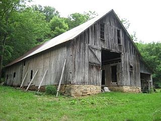
The Big Buffalo Valley Historic District, also known as the Boxley Valley Historic District, is notable as a cultural landscape in Buffalo National River. It comprises the Boxley Valley in northern Arkansas, near the town of Ponca. The valley includes a number of family-operated farms, primarily dating between 1870 and 1930. The farms are situated on either side of the road that parallels the river, Highway 43. Many of these farms are still operated by the descendants of the original homesteaders. However, of fifty residences in the valley, thirty were vacant in 1987, at the time of historic designation.

Buffalo River State Park was an Arkansas state park, established in 1938, that was absorbed into Buffalo National River when the Federal park was established in 1972. The area is now known as Buffalo Point. The new state park was developed with Civilian Conservation Corps labor in 1939 with the construction of park structures to plans from the National Park Service Branch of Plans and Designs. The CCC structures now comprise a historic district on the National Register of Historic Places.

The Rush Historic District is a zinc mining region of the Ozark Mountains in Arkansas. Now located within Buffalo National River, the district includes ruins dating from 1880 to 1940. The area was an important part of what became known as the North Arkansas Lead and Zinc District, and played a role in the development of railroads and modern infrastructure in the area.

Blackstone River Valley National Historical Park is a National Park Service unit in the states of Rhode Island and Massachusetts. The park was created for the purpose of preserving, protecting, and interpreting the industrial heritage of the Blackstone River Valley and the urban, rural, and agricultural landscape of that region. The Blackstone River Valley was the site of some of the earliest successful textile mills in the United States, and these mills contributed significantly to the earliest American Industrial Revolution. The subsequent construction of the Blackstone Canal, a few years after the successful completion of the Erie Canal, helped to sustain the region's industrial strength.


