
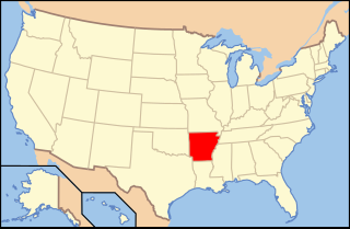
Marion County is located in the Ozark Mountains in the U.S. state of Arkansas. The county is named for Francis Marion, the famous "Swamp Fox" of the Revolutionary War. Created as Arkansas's 35th county in 1836, Marion County is home to one incorporated town and four incorporated cities, including Yellville, the county seat. The county is also the site of numerous unincorporated communities and ghost towns. The county included part of what is now Searcy County, Arkansas, with many opposing to dividing them, which helped fueled the bloody Tutt-Everett War between 1844 and 1850.

Poison Springs Battleground State Park is an Arkansas state park located southeast of Bluff City. It commemorates the Battle of Poison Spring in the American Civil War, which was part of the 1864 Camden Expedition, an element of a Union Army initiative to gain control of Shreveport, Louisiana and get a foothold in Texas.

Blue Spring Heritage Center is a 33-acre (13 ha) privately owned tourist attraction in the Arkansas Heritage Trails System containing native plants and hardwood trees in a setting of woodlands, meadows, and hillsides. It is located at Highway 62 West, five miles (8 km) west of Eureka Springs, Arkansas, and open daily to the public during warmer months for a fee.

This is a list of properties and historic districts in Arkansas that are listed on the National Register of Historic Places. There are more than 2,600 listings in the state, including at least 8 listings in each of Arkansas's 75 counties.

Highway 77 is a north–south state highway in Northeast Arkansas. The route of 66.70 miles (107.34 km) runs from US 70 in West Memphis north along Interstate 55 to the Missouri state line.
The following is an alphabetical list of articles related to the U.S. state of Arkansas.

U.S. Route 62 is a U.S. highway running from El Paso, Texas northeast to Niagara Falls, New York. In the U.S. state of Arkansas, the route runs 329.9 miles from the Oklahoma border near Summers east to the Missouri border in St. Francis, serving the northern portion of the state. The route passes through several cities and towns, including Fayetteville, Springdale, Bentonville, Harrison, Mountain Home, Pocahontas, and also Piggott. US 62 runs concurrent with several highways in Arkansas including Interstate 49 and U.S. Route 71 between Fayetteville and Bentonville, U.S. Route 412 through much of the state, U.S. Route 65 in the Harrison area, and with U.S. Route 63 and U.S. Route 67 in northeast Arkansas.

This is a list of the National Register of Historic Places listings in Marion County, Arkansas.

The Crooked Creek Bridge is a concrete arch bridge that carries U.S. Route 62 Spur over Crooked Creek in Pyatt, Arkansas. Built in 1923, the bridge was listed on the National Register of Historic Places on January 21, 2010.
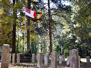
The Camp White Sulphur Springs Confederate Cemetery is an American Civil War cemetery in Arkansas. It is located northeast of the village of Sulphur Springs, also known as White Sulphur Springs, in Jefferson County.
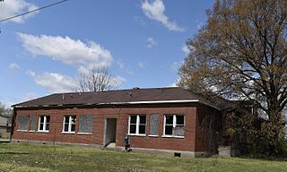
The Marion Colored High School is a historic school building at the northwest corner of Arkansas Highway 77 and Gannt Street in Sunset, Arkansas. It is a single-story brick structure, roughly in an H shape, with hipped roofs on the wings. The oldest portion of the building, a U-shaped section, was built in 1924 with funding from the Rosenwald Fund, and was extended to its present shape sometime before 1940. The original construction is of load-bearing brick, while the added wings are frame construction finished in a matching brick veneer. It was the first school built for African-American students in the area, originally serving grades 1–8. In 1937 the school acquired high school status, and served students from four states in the region, prompting its enlargement. In 1955 it was remodeled for use exclusively as a high school. It is now closed, and only used for special events.

Aggie Hall is a historic former gymnasium in Bruno, Arkansas, a short way south of Arkansas Highway 235. It is a single-story stone structure, topped by a hip roof which has a clerestory section at its center. The clerestory is finished in weatherboard; both roof lines have Craftsman-style exposed rafter ends. The building was erected in 1926 by the student members of the Lincoln Aggie Club, believed to be the first chapter established of the Future Farmers of America, and was originally intended as a gymnasium for the adjacent Bruno School and as a location for the club's activities.
The Aggie Workshop is a historic former school building on Marion County Road 5010 in Bruno, Arkansas. It is a single-story L-shaped structure, built out of local stone and topped by a hip roof with Craftsman-style exposed rafter tails. The WPA-approved building was built in 1935 by the Lincoln Aggie Club and was used as a vocational stone and cement workshop, as part of the local school. A cement swimming pool, contemporaneous to the building's construction, is located in the crook of the L.
The Bruno School Building was a historic school building a short way south of Arkansas Highway 9 in Bruno, Arkansas. It was a single story Plain Traditional (vernacular) frame structure, with a gable roof and a front porch with gabled pediment. Built in 1920, it had some Craftsman style influence, including exposed rafter tails and the square columns on stone piers which supported the porch. It was a locally significant well-preserved example of a rural school building.

The Eros School Building is a historic school building in the small rural community of Eros, Arkansas, at the junction of Arkansas Highway 125 and Marion County Road 4018. It is a single-story Plain Tradition stone structure, with a Craftsman-style side-gable roof with exposed rafter tails. A gable-topped porch projects from the main (west-facing), supported by slender columns on a concrete base. The porch pediment, like those on the sides, is stuccoed. The school was built in 1935 as part of a Depression-era jobs program.

The Fairview School Building is a historic school building in rural Marion County, Arkansas. It is located on the north side of County Road 8064, just west of its junction with Arkansas Highway 178 and the Fairview fire department. It is a single-story stone structure with a gabled tin roof whose eaves have exposed rafter tails in the Craftsman style. Its walls are of both cut and uncut fieldstone, and the foundation is also stone. The main (south-facing) facade is symmetrical, with sash windows flanking a raised double door. The school was built in 1927 by local volunteer labor, despite a downturn in the area's population and economy.

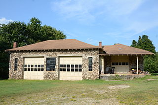
Hirst-Mathew Hall is a historic school building in Bruno, Arkansas. It is located in a complex included several other school buildings south of Arkansas Highway 235, between County Roads 5008 and 5010. It is a single-story stone structure, with a gable-on-hip roof that has exposed rafter ends in the Craftsman style. The main (north-facing) facade has a centered gable-roof porch supported by four columns set on a raised concrete base. The east facade has 14 windows, placed asymmetrically in groups of six, three and five. The west facade has 12 windows in two groups of six. It was built in 1929 as part of the Bruno Agricultural School, and originally housed classrooms. When it was listed on the National Register of Historic Places in 1992, it was in use as a textile factory.

The Pyatt School Building is a historic school building on Old Schoolhouse Road in Pyatt, Arkansas. It is a single-story stone structure, with a hip roof that extended eaves and exposed rafter tails in the Craftsman style, and a Colonial Revival recessed entry sheltered by a gable-roof portico. The school was built in 1925, as the community was adjusting to a decline of a mining boom begun in the 1910s.

The Spring Valley School District 120 Building is a historic school building on County Road 379 in the small village of Spring Valley, Washington County, Arkansas, behind the Spring Valley Baptist Church. It is a single-story stone masonry structure with a hip roof and an entrance recessed under an arched corner porch. It was built in 1934, at the height of the Great Depression, apparently through local efforts, and is reflective of that period of public education in the Ozark region.

Cold Spring is a small fresh-water spring in Ouachita National Forest, east of Waldron, Arkansas in Scott County. It is located on the south side of County Road 93, a short way south of where the road crosses Sugar Creek. The spring is protected by a stone and concrete structure erected by a crew of the Civilian Conservation Corps in c. 1936 to prevent contamination of the spring and erosion of the surrounding hillside. Near the spring are two open-air concrete water holding areas, from which a stone culvert channels the water to Sugar Creek. These CCC-built structures were listed on the National Register of Historic Places in 1993.


