
Yachats is a small coastal city in the southernmost area of Lincoln County, Oregon, United States. According to Oregon Geographic Names, the name comes from the Siletz language and means "dark water at the foot of the mountain". There is a range of differing etymologies. William Bright says the name comes from the Alsea placename yáx̣ayky. At the 2020 census, the city's population was 994.

Olympic National Park is a national park of the United States located in Washington, on the Olympic Peninsula. The park has four regions: the Pacific coastline, alpine areas, the west-side temperate rainforest, and the forests of the drier east side. Within the park there are three distinct ecosystems, including subalpine forest and wildflower meadow, temperate forest, and the rugged Pacific coast.

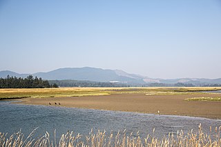
The Oregon Coast is a coastal region of the U.S. state of Oregon. It is bordered by the Pacific Ocean to its west and the Oregon Coast Range to the east, and stretches approximately 362 miles (583 km) from the California state border in the south to the Columbia River in the north. The region is not a specific geological, environmental, or political entity, and includes the Columbia River Estuary.

Humbug Mountain is one of the highest mountains in the U.S. state of Oregon to rise directly from the Pacific Ocean. It lies on the state's southern coast, about 6 miles (10 km) south of Port Orford and 21 miles (34 km) north of Gold Beach. The mountain is completely within Humbug Mountain State Park, and U.S. Route 101 passes by its northern base. Its slopes feature an old-growth temperate rainforest. Two trails run from the state park campground to the mountain's summit, one 1.5 miles (2.4 km) long, the other 2 miles (3.2 km) long. Both are part of the much longer Oregon Coast Trail. The area is popular with hikers, campers, cyclists, and whale watchers although biking and camping on the mountain itself are prohibited.
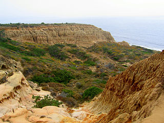
Torrey Pines State Natural Reserve is a coastal state park in San Diego, California. The reserve is one of the wildest stretches of land on the Southern California coast, covering 2,000 acres (810 ha). It is bordered immediately to the south by Torrey Pines Golf Course and to the north by the city of Del Mar. The reserve was designated a National Natural Landmark in 1977.

The Oregon Coast Trail (OCT) is a long-distance hiking route along the Pacific coast of the U.S. state of Oregon in the United States. It follows the coast of Oregon from the mouth of the Columbia River to the California border south of Brookings.
Devil's Punch Bowl may refer to:

Natural Bridges State Beach is a 65-acre (26 ha) California state park in Santa Cruz, California, in the United States. The park features a natural bridge across a section of the beach and a eucalyptus grove provides habitat for monarch butterflies. During monarch butterfly migration, Monarch Butterfly Natural Preserve has up to 150,000 monarch butterflies from October through early February.

Sonoma Coast State Park is a State of California property in Sonoma County consisting of public access use on lands adjoining the Pacific Ocean. This extent of beach runs from a coastal point about 4 miles (6 km) north of Jenner and continues for approximately 17 miles (27 km) to the south to terminate at Bodega Head. The property lies along State Route 1 and consists of a number of named beaches including Arched Rock Beach, Gleason Beach and Goat Rock Beach. The ecosystem consists of alternating sandy beaches and rocky shoreline, with a marine terrace extending above the entire extent with an upland California coastal prairie habitat.
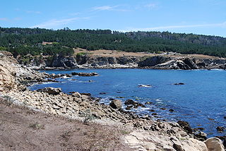
Salt Point State Park is a state park in Sonoma County, California, United States. The park covers 6,000 acres (2,428 ha) on the coast of Northern California, with 20 miles (32 km) of hiking trails and over 6 miles (9.7 km) of a rough rocky coastline including Salt Point which protrudes into the Pacific Ocean. The park also features the first underwater preserves in California. The constant impact of the waves forms the rocks into many different shapes. These rocks continue underwater providing a wide variety of habitats for marine organisms. The activities at Salt Point include hiking, camping, fishing, scuba diving and many others. The weather is often cool with fog and cold winds, even during the summer.

Otter Rock is an unincorporated community in Lincoln County, Oregon, United States. It is located on U.S. Route 101 along the Oregon Coast. Otter Rock is 5.4 miles south of Depoe Bay and 8 miles north of Newport, Oregon. Otter Rock takes its name from a rock located about 1⁄2 mile (0.8 km) offshore and 3.25 miles (5.23 km) north of Yaquina Head where sea otters formerly lived.
The Oregon Coast National Wildlife Refuge Complex consists of six National Wildlife Refuges along the Oregon Coast. It provides wilderness protection to thousands of small islands, rocks, reefs, headlands, marshes, and bays totaling 371 acres spanning 320 miles (515 km) of Oregon's coastline. The areas are all managed by the United States Fish and Wildlife Service.

Moolack Beach is an undeveloped sandy beach on the Oregon Coast about 4 miles (6 km) north of Newport in Lincoln County, United States. It is almost 8 km (5 mi) in length with the south end at Yaquina Head and the north end at Otter Rock, the site of Devils Punch Bowl State Natural Area. The northern beach is the site of Beverly Beach State Park and the community of Beverly Beach. The beach has no obvious break delineating what would seem to be Beverly Beach, though Wade Creek is a likely candidate. The nearly ten-foot (3-metre) tidal range and seasonally varying slope of the beach can cause the sandy beach to completely disappear at times; at other times it can be hundreds of feet wide. The beach is bounded by U.S. Route 101.

Cape Perpetua is a large forested headland projecting into the Pacific Ocean on the central Oregon Coast in Lincoln County, Oregon. The land is managed by the United States Forest Service as part of the Siuslaw National Forest.

Wilder Ranch State Park is a California State Park on the Pacific Ocean coast north of Santa Cruz, California. The park was formerly a dairy ranch, and many of the ranch buildings have been restored for use as a museum. There are no campgrounds; a day-use parking lot provides access to the museum. Dogs are prohibited on the trails, but many trails allow bikes and/or horses. The long trails and ocean views make the area a favorite of hikers, equestrians and mountain bikers. Public beaches continue to the north in Coast Dairies State Park.

Erratic Rock State Natural Site is a state park in the Willamette Valley of Oregon, United States. Featuring a 40-short-ton (36 t) glacial erratic from the Missoula Floods, the small park sits atop a foothill of the Northern Oregon Coast Range in Yamhill County between Sheridan and McMinnville off Oregon Route 18. The day-use-only park is owned and maintained by the Oregon Parks and Recreation Department.
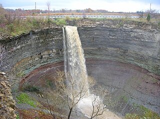
Devil's Punch Bowl is a 37-metre ribbon waterfall on the Niagara Escarpment, in the Stoney Creek community of Hamilton, Ontario, Canada. It is in the Devil's Punchbowl Conservation Area maintained by the Hamilton Conservation Authority, and features an escarpment access trail with connections to a section of the Bruce Trail. Stoney Creek's Dofasco 2000 Trail is nearby. The Punch Bowl is also known as Horseshoe Falls for the distinctive shape of the cliff-face, which somewhat resembles its much larger cousin in Niagara Falls.
Bandon State Natural Area is a state park in the U.S. state of Oregon. It is administered by the Oregon Parks and Recreation Department. The 879-acre (356 ha) park lies west of U.S. Route 101, off Beach Loop Drive, about 5 miles (8 km) south of Bandon. The Oregon Coast Trail passes through the park.

D River State Recreation Site is a state park in the U.S. state of Oregon, administered by the Oregon Parks and Recreation Department. It is a sandy beach of the Pacific Ocean within central Lincoln City along the length of the 120-foot (37 m) long D River, one of the world's shortest rivers.
Sitka Sedge State Natural Area is an estuary and beach on the north coast of the U.S. state of Oregon in Tillamook County. Sitka Sedge consists of 357 acres (144 ha) of tidal marsh, mudflats, dunes, forested wetlands, and uplands at the south end of the Sand Lake estuary, north of Tierra Del Mar.


