
The Willamette River is a major tributary of the Columbia River, accounting for 12 to 15 percent of the Columbia's flow. The Willamette's main stem is 187 miles (301 km) long, lying entirely in northwestern Oregon in the United States. Flowing northward between the Oregon Coast Range and the Cascade Range, the river and its tributaries form the Willamette Valley, a basin that contains two-thirds of Oregon's population, including the state capital, Salem, and the state's largest city, Portland, which surrounds the Willamette's mouth at the Columbia.

West Linn is a city in Clackamas County, Oregon, United States. A southern suburb within the Portland metropolitan area, West Linn developed on the site of the former Linn City, which was named after U.S. Senator Lewis F. Linn of Ste. Genevieve, Missouri, who had advocated the American occupation of the Oregon territory as a counterclaim to the British.

Albany is the county seat of Linn County, Oregon, and is the 11th most populous city in the state. Albany is located in the Willamette Valley at the confluence of the Calapooia River and the Willamette River in both Linn and Benton counties, just east of Corvallis and south of Salem. It is predominantly a farming and manufacturing city that settlers founded around 1848. As of the 2020 United States Census, the population of Albany, Oregon was 56,472.

The Molalla River is a 51-mile (82 km) tributary of the Willamette River in the northwestern part of Oregon in the United States. Flowing northwest from the Cascade Range through Table Rock Wilderness, it passes the city of Molalla before entering the larger river near Canby. The Molalla is the largest Willamette tributary unblocked by a dam.

The McKenzie River is a 90-mile (145 km) tributary of the Willamette River in western Oregon in the United States. It drains part of the Cascade Range east of Eugene and flows westward into the southernmost end of the Willamette Valley. It is named for Donald McKenzie, a Scottish Canadian fur trader who explored parts of the Pacific Northwest for the Pacific Fur Company in the early 19th century. As of the 21st century, six large dams have been built on the McKenzie and its tributaries.

The Willamette Falls is a natural waterfall in the northwestern United States, located on the Willamette River between Oregon City and West Linn, Oregon. The largest waterfall in the Northwest U.S. by volume, it is the seventeenth widest in the world. Horseshoe in shape, it is 1,500 feet (455 m) wide and forty feet (12 m) high, with a flow rate of 30,850 cu ft/s (874 m3/s). Located 26 miles (42 km) upriver from the Willamette's mouth at Portland. Willamette Falls is a culturally significant site for many tribal communities in the region.

Forest Park is a public municipal park in the Tualatin Mountains west of downtown Portland, Oregon, United States. Stretching for more than 8 miles (13 km) on hillsides overlooking the Willamette River, it is one of the country's largest urban forest reserves. The park, a major component of a regional system of parks and trails, covers more than 5,100 acres (2,064 ha) of mostly second-growth forest with a few patches of old growth. More than 80 miles (130 km) of recreational trails, including the Wildwood Trail segment of the city's 40-Mile Loop system, crisscross the park.
The Albany Parks & Recreation is a city agency in Albany, Oregon, United States responsible for maintaining the local city parks as well as organizing cultural events. Its headquarters are at City Hall, 333 Broadalbin Street SW. One goal of the City of Albany is to have all residents live within 2 miles (3 km) of a park.

The Molalla River State Park is located in U.S. state of Oregon. It is a few miles north of Canby, and half a mile from the Canby Ferry. The park is south of the Willamette River and east of the Molalla River, at the confluence of the Pudding, Molalla and Willamette rivers. The Pudding River flows into the Molalla from the west, just before the Molalla joins the Willamette. The floodplains of these rivers provide important habitat for waterfowl, wading birds, deer, small mammals, reptiles and amphibians. A blue heron rookery, one of the largest in the Willamette Valley, is located in Molalla River State Park.
Tryon Creek is a 4.85-mile (7.81 km) tributary of the Willamette River in the U.S. state of Oregon. Part of the drainage basin of the Columbia River, its watershed covers about 6.5 square miles (16.8 km2) in Multnomah and Clackamas counties. The stream flows southeast from the Tualatin Mountains through the Multnomah Village neighborhood of Portland and the Tryon Creek State Natural Area to the Willamette in the city of Lake Oswego. Parks and open spaces cover about 21 percent of the watershed, while single-family homes dominate most of the remainder. The largest of the parks is the state natural area, which straddles the border between the two cities and counties.

Santiam State Forest is one of six state forests managed by the Oregon Department of Forestry. The forest is located approximately 25 miles (40 km) southeast of Salem, Oregon, and includes 47,871 acres (193.73 km2) on the western slope of the Cascade Mountains in three Oregon counties: Clackamas, Linn, and Marion. It is bounded on the east by the Willamette National Forest and Mount Hood National Forest. Silver Falls State Park is located west of the forest. The rest of the land surrounding the forest belongs to the Bureau of Land Management or is privately owned. The forest is managed as part of the Department of Forestry's North Cascade District.
Fanno Creek is a 15-mile (24 km) tributary of the Tualatin River in the U.S. state of Oregon. Part of the drainage basin of the Columbia River, its watershed covers about 32 square miles (83 km2) in Multnomah, Washington, and Clackamas counties, including about 7 square miles (18 km2) within the Portland city limits.

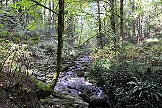
Balch Creek is a 3.5-mile (5.6 km) tributary of the Willamette River in the U.S. state of Oregon. Beginning at the crest of the Tualatin Mountains, the creek flows generally east down a canyon along Northwest Cornell Road in unincorporated Multnomah County and through the Macleay Park section of Forest Park, a large municipal park in Portland. At the lower end of the park, the stream enters a pipe and remains underground until reaching the river. Danford Balch, after whom the creek is named, settled a land claim along the creek in the mid-19th century. After murdering his son-in-law, he became the first person legally hanged in Oregon.

Willamette Mission State Park is a state park in the U.S. state of Oregon, located about four miles (6 km) north of Keizer adjacent to the Wheatland Ferry and east of the Willamette River. It includes Willamette Station Site, Methodist Mission in Oregon, which is listed by the National Register of Historic Places.

The Columbia Slough is a narrow waterway, about 19 miles (31 km) long, in the floodplain of the Columbia River in the U.S. state of Oregon. From its source in the Portland suburb of Fairview, the Columbia Slough meanders west through Gresham and Portland to the Willamette River, about 1 mile (1.6 km) from the Willamette's confluence with the Columbia. It is a remnant of the historic wetlands between the mouths of the Sandy River to the east and the Willamette River to the west. Levees surround much of the main slough as well as many side sloughs, detached sloughs, and nearby lakes. Drainage district employees control water flows with pumps and floodgates. Tidal fluctuations cause reverse flow on the lower slough.

Erratic Rock State Natural Site is a state park in the Willamette Valley of Oregon, United States. Featuring a 40-short-ton (36 t) glacial erratic from the Missoula Floods, the small park sits atop a foothill of the Northern Oregon Coast Range in Yamhill County between Sheridan and McMinnville off Oregon Route 18. The day-use-only park is owned and maintained by the Oregon Parks and Recreation Department.

Cascadia State Park is a state park in the U.S. state of Oregon near Sweet Home along the South Santiam River at Cascadia. The park includes a day use area, campsites, hiking trails and 150 foot Lower Soda Creek Falls.

Cline Falls State Scenic Viewpoint is a state park near Redmond, Oregon, United States. It is located on the Deschutes River. The park covers 9 acres (36,000 m2). It is administered by the Oregon Parks and Recreation Department.

Blue Lake Regional Park is a public park in Fairview, in the U.S. state of Oregon. The 101-acre (41 ha) park, near the south shore of the Columbia River in Multnomah County, includes many covered and uncovered picnic areas, playing fields for sports such as softball, a cross country course and infrastructure related to lake recreation including swimming, boating, and fishing. Encompassing wooded areas, three ponds, and a wetland in addition to the lake, the park is frequented by migrating birds and other wildlife. Paved paths run through the park, which is near the 40-Mile Loop hiking and biking trail. Park vegetation includes cottonwoods, willows, and other trees and shrubs as well as wetland plants such as cattails.

The Willamette Valley is a 150-mile (240 km) long valley in Oregon, in the Pacific Northwest region of the United States. The Willamette River flows the entire length of the valley and is surrounded by mountains on three sides: the Cascade Range to the east, the Oregon Coast Range to the west, and the Calapooya Mountains to the south.


