Image Crossing Carries Location River mile Year built Coordinates OR 99E bridge OR 99E , sidewalk Harrisburg 161.2 1925 44°16′01″N 123°10′29″W / 44.26708°N 123.17483°W / 44.26708; -123.17483 (Oregon Route 99E bridge ) Oregon Electric rail bridge; former vertical-lift type, now fixed in place (formerly) Oregon Electric Railway , Burlington Northern (currently) Portland and Western Railroad Junction City 162.7 1912 44°14′55″N 123°10′31″W / 44.24864°N 123.17538°W / 44.24864; -123.17538 (rail bridge ) (Oregon and California Railroad ) Southern Pacific rail bridge; former swing-span type, now concrete-steel truss bridge (formerly) Southern Pacific (currently) Union Pacific Railroad Amtrak Junction City 162.8 1871/1905/2014 44°14′53″N 123°10′28″W / 44.24815°N 123.17451°W / 44.24815; -123.17451 (rail bridge ) Beltline Highway (westbound), sidewalk OR 569 west Eugene 178.2 1961 44°05′43″N 123°06′23″W / 44.09525°N 123.10651°W / 44.09525; -123.10651 (Beltline Highway (westbound) ) Beltline Highway (eastbound) OR 569 east Eugene 178.2 1966 44°05′43″N 123°06′24″W / 44.09519°N 123.10666°W / 44.09519; -123.10666 (Beltline Highway (eastbound) ) Owosso Bicycle Bridge Eugene 178.7 1985 44°05′31″N 123°06′58″W / 44.09185°N 123.11609°W / 44.09185; -123.11609 (Owosso Bicycle Bridge ) Greenway Bicycle Bridge Eugene 180.6 1978 44°04′03″N 123°06′42″W / 44.06750°N 123.11175°W / 44.06750; -123.11175 (Greenway Bicycle Bridge ) Washington-Jefferson Street Bridge I-105 / OR 126 Eugene 181.2 1960 44°03′50″N 123°06′03″W / 44.06391°N 123.10076°W / 44.06391; -123.10076 (Washington-Jefferson Street Bridge ) Ferry Street Bridge Coburg Road Eugene 182.2 1950 44°03′29″N 123°05′02″W / 44.05794°N 123.08391°W / 44.05794; -123.08391 (Ferry Street Bridge ) Peter DeFazio Bicycle Bridge Eugene 182.35 2000 44°03′25″N 123°05′01″W / 44.05691°N 123.08352°W / 44.05691; -123.08352 (Peter DeFazio Bicycle Bridge )
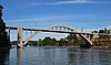
Dave and Lynn Frohnmayer Pedestrian and Bicycle Bridge [ 1] Eugene 182.7 1970 44°03′06″N 123°04′17″W / 44.05160°N 123.07127°W / 44.05160; -123.07127 (Dave and Lynn Frohnmayer Pedestrian and Bicycle Bridge ) Knickerbocker Bicycle Bridge Eugene 183.8 1978 44°02′43″N 123°03′08″W / 44.04529°N 123.05214°W / 44.04529; -123.05214 (Knickerbocker Bicycle Bridge ) Whilamut Passage Bridge (west span) I-5 south Eugene 183.91 2011 44°02′43″N 123°03′00″W / 44.04540°N 123.05010°W / 44.04540; -123.05010 (Whilamut Passage Bridge ) Whilamut Passage Bridge (east span) I-5 north Eugene 183.92 2013 [ 2] 44°02′44″N 123°02′58″W / 44.04550°N 123.04958°W / 44.04550; -123.04958 (Whilamut Passage Bridge ) Springfield Bridge (north span) OR 126 Bus. west (Main Street) , sidewalks Springfield 185.25 1950 44°02′44″N 123°01′39″W / 44.04544°N 123.02743°W / 44.04544; -123.02743 (Springfield Bridge (north span) ) Springfield Bridge (south span) OR 126 Bus. east (South "A" Street) , sidewalk Springfield 185.3 44°02′42″N 123°01′38″W / 44.04511°N 123.02718°W / 44.04511; -123.02718 (Springfield Bridge (south span) ) Springfield Southern Pacific Rail bridge Union Pacific Railroad Amtrak Springfield 185.4 1906/1926 44°02′35″N 123°01′34″W / 44.04308°N 123.02615°W / 44.04308; -123.02615 (Southern Pacific Rail bridge )