Fremont Bridge (Portland, Oregon)

Last updated

Fremont Bridge
FremontBridgePano.jpg
Coordinates 45°32′16″N122°40′57″W / 45.5377083°N 122.6825027°W / 45.5377083; -122.6825027
CarriesFour lanes, two decks
I-405.svgUS 30.svg I-405  / US 30
Crosses Willamette River and surface streets
Locale Portland, Oregon
Official nameFremont Bridge
Maintained by Oregon Department of Transportation
ID number 02529
Characteristics
Design Tied-arch bridge
Total length2,154 feet (657 m)
Height381 feet (116 m)
Longest span1,255 feet (383 m)
longest in Oregon
Clearance above 18.3 feet (5.6 m)
Clearance below 175 feet (53 m)
History
OpenedNovember 15, 1973 [1]
Location
Fremont Bridge (Portland, Oregon)

The Fremont Bridge is a steel tied-arch bridge over the Willamette River located in Portland, Oregon, United States. It carries Interstate 405 and US 30 traffic between downtown and North Portland where it intersects with Interstate 5. It has the longest main span of any bridge in Oregon and is the second longest tied-arch bridge in the world (after Caiyuanba Bridge across the Yangtze River, China). [2] The bridge was designed by Parsons, Brinckerhoff, Quade and Douglas, and built by Murphy Pacific Corporation. [3]

Contents

The bridge has two decks carrying vehicular traffic, each with four lanes. The upper deck is signed westbound on US 30 and southbound on I-405. The lower deck is signed eastbound on US 30 and northbound on I-405.

Mount St. Helens erupting on May 18, 1980, with the Fremont Bridge visible in the lower left corner. MSH-10B Mount St. Helens Erupts, Portland View, May 18, 1980 (22636191326).jpg
Mount St. Helens erupting on May 18, 1980, with the Fremont Bridge visible in the lower left corner.

Design and construction

Due to the public's dissatisfaction with the appearance of the Marquam Bridge, the Portland Art Commission was invited to participate in the design process of the Fremont. The improvement in visual quality resulted in a bridge that was nearly six times as expensive as the purposely economical Marquam Bridge. Designers modeled the bridge after the original 1964 Port Mann Bridge in Vancouver, British Columbia.

The steel tie-girder (I-beam) is 18 feet (5.5 m) tall and 50 inches (130 cm) wide. On October 28, 1971, while still under construction, a six-foot-long (1.8 m) crack was found on the west span of this girder that required a $5.5 million redesign and repair. The ramps and approaches are steel box girders. If the lanes of the bridge were placed end-to-end, there are 3.27 lane-miles (5.26 lane-km) on the arch bridge and 14.12 lane-miles (22.72 lane-km) on the ramps and approaches. [3]

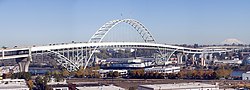
The center span of the bridge, where the rib of the arch is above the deck, is 902 feet (275 m) long. [3] It was fabricated in California then assembled at Swan Island Industrial Park, 1.7 miles (2.7 km) downstream. [2] After assembly it was floated on a barge the 1.7-mile (2.7 km) trip to the construction site. [3] On March 16, 1973, the 6,000 short tons (5,400 t) steel arch span was lifted 170 ft (52 m) using 32 hydraulic jacks. At the time, it was listed in the Guinness Book of World Records as the heaviest lift ever completed. [4]

The bridge was opened on November 15, 1973, [1] [2] at a final cost of $82 million (equivalent to $593 million in 2022), [2] most of which was financed by the Federal Highway Administration. In 1976, an American flag and an Oregon flag were added atop the structure as part of the bicentennial celebration for the United States. [5] The flags were installed with the use of a helicopter. [3] The 15-by-25-foot (4.6 m × 7.6 m) flags are attached to 50-foot (15 m) tall flagpoles at the crest of the arches. [5]

Falcon nest

The Fremont Bridge was also the 26th Peregrine falcon nest site designated in Oregon in 1995 after the raptor was placed on the U.S. Threatened and Endangered Species list in 1970. [6]

The raptor has since been removed from the list and is now listed as least concern. [7]

Etymology

The bridge as well as Portland's associated Fremont Street were named for John C. Fremont (1813–1890). Fremont was an early explorer of the Oregon Country. He served in the United States Army at the time as a Captain and was later promoted to General. In 1856, he ran for president, but was defeated by James Buchanan. [8]


USACE Fremont Bridge Portland.jpg
Fremont Bridge and the skyline of Portland c.1988
FremontBridgeBottom.jpg
From the east end
Fremont bridge pedal 1230.jpeg
Annual Bridge Pedal on the top deck of the Fremont Bridge
Amtrak underneath Fremont Bridge.jpg
An Amtrak train passing beneath the Fremont Bridge
Vigor and the Fremont Bridge.jpg
The Fremont Bridge from the University of Portland
Fremont Bridge Sunset, Portland (19386167285).jpg
Looking west at the Fremont Bridge during sunset


See also

Related Research Articles

<span class="mw-page-title-main">Steel Bridge</span> Bridge in Portland, Oregon

The Steel Bridge is a through truss, double-deck vertical-lift bridge across the Willamette River in Portland, Oregon, United States, opened in 1912. Its lower deck carries railroad and bicycle/pedestrian traffic, while the upper deck carries road traffic, and light rail (MAX), making the bridge one of the most multimodal in the world. It is the only double-deck bridge with independent lifts in the world and the second oldest vertical-lift bridge in North America, after the nearby Hawthorne Bridge. The bridge links the Rose Quarter and Lloyd District in the east to Old Town Chinatown neighborhood in the west.

<span class="mw-page-title-main">St. Johns Bridge</span> Bridge in Portland, Oregon

The St. Johns Bridge is a steel suspension bridge that spans the Willamette River in Portland, Oregon, United States, between the Cathedral Park neighborhood in North Portland and the Linnton and Northwest Industrial neighborhoods in Northwest Portland. It carries the U.S. Route 30 Bypass. It is the only suspension bridge in the Willamette Valley and one of three public highway suspension bridges in Oregon.

<span class="mw-page-title-main">Hawthorne Bridge</span> Bridge over the Willamette River in Portland, Oregon

The Hawthorne Bridge is a truss bridge with a vertical lift that spans the Willamette River in Portland, Oregon, joining Hawthorne Boulevard and Madison Street. It is the oldest vertical-lift bridge in operation in the United States and the oldest highway bridge in Portland. It is also the busiest bicycle and transit bridge in Oregon, with over 8,000 cyclists and 800 TriMet buses daily. It was added to the National Register of Historic Places in November 2012.

<span class="mw-page-title-main">Burnside Bridge</span> Bridge in Portland, Oregon

The Burnside Bridge is a 1926-built bascule bridge that spans the Willamette River in Portland, Oregon, United States, carrying Burnside Street. It is the second bridge at the same site to carry that name. It was added to the National Register of Historic Places in November 2012.

<span class="mw-page-title-main">Morrison Bridge</span> Bridge in Oregon, U.S.

The Morrison Bridge is a bascule bridge that spans the Willamette River in Portland, Oregon. Completed in 1958, it is the third bridge at approximately the same site to carry that name. It is one of the most heavily used bridges in Portland. It was added to the National Register of Historic Places in November 2012.

<span class="mw-page-title-main">Marquam Bridge</span> Carries Interstate 5 traffic over the Willamette River in Portland, Oregon

The Marquam Bridge is a double-deck, steel-truss cantilever bridge that carries Interstate 5 traffic across the Willamette River from south of downtown Portland, Oregon, on the west side to the industrial area of inner Southeast on the east. It is the busiest bridge in Oregon, carrying 140,500 vehicles a day as of 2016. The upper deck carries northbound traffic; the lower deck carries southbound traffic. The Marquam also has on and off ramps for Interstate 405 on the south end of the bridge, while the terminus on the east bank of the river is near the interchange with Interstate 84.

<span class="mw-page-title-main">Broadway Bridge (Portland, Oregon)</span> Bridge in Portland, Oregon

The Broadway Bridge is a Rall-type bascule bridge spanning the Willamette River in Portland, Oregon, United States, built in 1913. It was Portland's first bascule bridge, and it continues to hold the distinction of being the longest span of its bascule design type in the world. It was added to the National Register of Historic Places in November 2012.

<span class="mw-page-title-main">Ross Island Bridge</span> Bridge in Portland, Oregon

The Ross Island Bridge is a cantilever truss bridge that spans the Willamette River in Portland, Oregon. It carries U.S. Route 26 across the river between southwest and southeast Portland. The bridge opened in 1926 and was designed by Gustav Lindenthal and honors Oregon pioneer Sherry Ross. It is named for its proximity to Ross Island. Although it looks like a deck arch bridge, it is a cantilever deck truss bridge, a rare type in Oregon.

<span class="mw-page-title-main">Sellwood Bridge</span> Bridge in Portland, OR

The Sellwood Bridge is a deck arch bridge that spans the Willamette River in Portland, Oregon, in the United States. The current bridge opened in 2016 and replaced a 1925 span that had carried the same name. The original bridge was Portland's first fixed-span bridge and, being the only river crossing for miles in each direction, the busiest two-lane bridge in Oregon. The Sellwood Bridge links the Sellwood and Westmoreland neighborhoods of Portland on the east side with Oregon Route 43/Macadam Avenue on the west side. At its east end it leads to Tacoma Street. The bridge is owned and operated by Multnomah County. The original span of 1925 was a steel truss bridge, while its 2016 replacement is a deck-arch-type bridge.

<span class="mw-page-title-main">BNSF Railway Bridge 5.1</span> Railroad bridge in Portland, Oregon

The BNSF Railway Bridge 5.1, also known as the St. Johns Railroad Bridge or the Willamette River Railroad Bridge, is a through truss railway bridge with a vertical lift that spans the Willamette River in Portland, Oregon, United States. Built by the Spokane, Portland and Seattle Railway (SP&S) and completed in 1908, it was originally a swing-span bridge, and its swing-span section was the longest in the world at the time. However, 81 years later the main span was converted from a swing-type to a vertical-lift type, in order to widen the navigation channel. The lift span is one of the highest and longest in the world. The bridge consists of five sections, with the two sections closest to the bank on each side fixed.

<span class="mw-page-title-main">Abernethy Bridge</span> Bridge in Oregon City, Oregon

The George Abernethy Bridge, or simply Abernethy Bridge, is a steel plate and box girder bridge that spans the Willamette River between Oregon City and West Linn, Oregon, United States, and which carries Interstate 205. It is also known as the Oregon City Freeway Bridge and the I-205 Bridge.

<span class="mw-page-title-main">Yaquina Bay Bridge</span> Bridge in Newport, Oregon

The Yaquina Bay Bridge is an arch bridge that spans Yaquina Bay south of Newport, Oregon. It is one of the most recognizable of the U.S. Route 101 bridges designed by Conde McCullough and one of eleven major bridges on the Oregon Coast Highway designed by him. It superseded the last ferry crossing on the highway.

<span class="mw-page-title-main">Interstate 405 (Oregon)</span> Interstate highway in Portland, Oregon, U.S.

Interstate 405 (I-405), also known as the Stadium Freeway No. 61, is a short north–south Interstate Highway in Portland, Oregon. It forms a loop that travels around the west side of Downtown Portland, between two junctions with I-5 on the Willamette River near the Marquam Bridge to the south and Fremont Bridge to the north.

<span class="mw-page-title-main">Downtown Portland, Oregon</span> Neighborhood in Portland, Oregon, United States

Downtown Portland is the central business district of Portland, Oregon, United States. It is on the west bank of the Willamette River in the northeastern corner of the southwest section of the city and where most of the city's high-rise buildings are found.

<span class="mw-page-title-main">Harbor Drive</span> Road of historical significance in Portland, Oregon

Harbor Drive is a short roadway in Portland, Oregon, spanning a total length of 0.7 miles (1.1 km), which primarily functions as a ramp to and from Interstate 5. It was once much longer, running along the western edge of the Willamette River in the downtown area. Originally constructed from 1942–43, the vast majority of the road was replaced with Tom McCall Waterfront Park in the 1970s. Signed as U.S. Route 99W, it had been the major route through the city and its removal is often cited as the first instance of freeway removal in the U.S. and as a milestone in urban planning; the original road is remembered as the first limited-access highway built in the city.

<span class="mw-page-title-main">Boone Bridge (Oregon)</span> Bridge in Wilsonville, Oregon

Boone Bridge is a steel girder highway bridge over the Willamette River at Wilsonville, Oregon, in the United States. Built in 1954, it crosses the river to the Charbonneau section of Wilsonville, carrying Interstate 5 into the open Willamette Valley from the Portland metropolitan area. Maintained by the Oregon Department of Transportation, the 1,111-foot-long (339 m) bridge has three travel lanes in each direction. To the west is the site of the former Boone's Ferry, which the bridge replaced.

<span class="mw-page-title-main">Interstate 5 in Oregon</span> Interstate highway in Oregon

Interstate 5 (I-5) in the U.S. state of Oregon is a major Interstate Highway that traverses the state from north to south. It travels to the west of the Cascade Mountains, connecting Portland to Salem, Eugene, Medford, and other major cities in the Willamette Valley and across the northern Siskiyou Mountains. The highway runs 308 miles (496 km) from the California state line near Ashland to the Washington state line in northern Portland, forming the central part of Interstate 5's route between Mexico and Canada.

<span class="mw-page-title-main">Wapato Bridge</span> Bridge near Portland, Oregon, United States

The Wapato Bridge, formerly known as the Sauvie Island Bridge, crosses the Multnomah Channel of the Willamette River near Portland, Oregon, United States. The original Parker truss bridge, built in 1950 with a 200-foot (61 m) main span, was replaced with a tied arch bridge with a 360-foot (110 m) span in 2008 due to cracks discovered in 2001.

<span class="mw-page-title-main">Ellsworth Street Bridge</span> Bridge in Albany, Oregon

The Ellsworth Street Bridge is a highway bridge that crosses the Willamette River in Albany, Oregon, United States. Built in 1925, the two-lane structure carries U.S. Route 20 eastbound traffic, with the adjacent Lyon Street Bridge carrying westbound traffic. The 1,090-foot-long (330 m) steel truss bridge was designed by Conde McCullough and opened in 1926.

<span class="mw-page-title-main">Tilikum Crossing</span> Bridge over the Willamette River, Portland, OR, USA

Tilikum Crossing, Bridge of the People is a cable-stayed bridge across the Willamette River in Portland, Oregon, United States. It was designed by TriMet, the Portland metropolitan area's regional transit authority, for its MAX Orange Line light rail passenger trains. The bridge also serves city buses and the Portland Streetcar, as well as bicycles, pedestrians, and emergency vehicles. Private cars and trucks are not permitted on the bridge. It is the first major bridge in the U.S. that was designed to allow access to transit vehicles, cyclists and pedestrians but not cars.

References

  1. 1 2 "Fremont Bridge opens with wheeze". The Oregonian . November 16, 1973. p. 22.
  2. 1 2 3 4 Wood, Sharon; Wortman, Ed (2006). The Portland Bridge Book (3rd ed.). Urban Adventure Press. pp. 23–30. ISBN   0-9787365-1-6.
  3. 1 2 3 4 5 Bottenberg, Ray (2007). Bridges of Portland. Arcadia Publishing. pp. 105–116. ISBN   9780738548760.
  4. Smith, Dwight A.; Norman, James B.; Dykman, Pieter T. (1989). Historic Highway Bridges of Oregon. Oregon Historical Society Press. p. 300. ISBN   0-87595-205-4.
  5. 1 2 "News Q&A". The Oregonian . May 1, 2005.
  6. "Fremont Bridge Peregrines: A Decade of Successful Nesting". Audubon Society of Portland. Retrieved January 11, 2010.
  7. "Peregrine falcon". United States National Park Service. Retrieved May 19, 2023.
  8. Snyder, Eugene E. (1979). Portland Names and Neighborhoods: Their Historic Origin. Portland: Binford & Mort. p. 133.