
Wilsonville is a city in Clackamas and Washington counties in the U.S. state of Oregon. Founded with the name Boones Landing for the Boones Ferry that crossed the Willamette River, the community became Wilsonville in 1880. The city was incorporated in 1969 with a population of approximately 1,000. The population was 19,509 at the 2010 census and grew to 26,664 as of the 2020 census.
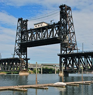
The Steel Bridge is a through truss, double-deck vertical-lift bridge across the Willamette River in Portland, Oregon, United States, opened in 1912. Its lower deck carries railroad and bicycle/pedestrian traffic, while the upper deck carries road traffic, and light rail (MAX), making the bridge one of the most multimodal in the world. It is the only double-deck bridge with independent lifts in the world and the second oldest vertical-lift bridge in North America, after the nearby Hawthorne Bridge. The bridge links the Rose Quarter and Lloyd District in the east to Old Town Chinatown neighborhood in the west.

The Hawthorne Bridge is a truss bridge with a vertical lift that spans the Willamette River in Portland, Oregon, joining Hawthorne Boulevard and Madison Street. It is the oldest vertical-lift bridge in operation in the United States and the oldest highway bridge in Portland. It is also the busiest bicycle bridge in Oregon, with over 8,000 cyclists and 800 TriMet buses daily. It was added to the National Register of Historic Places in November 2012.

The Fremont Bridge is a steel tied-arch bridge over the Willamette River located in Portland, Oregon, United States. It carries Interstate 405 and US 30 traffic between downtown and North Portland where it intersects with Interstate 5. It has the longest main span of any bridge in Oregon and is the second longest tied-arch bridge in the world. The bridge was designed by Parsons, Brinckerhoff, Quade and Douglas, and built by Murphy Pacific Corporation. In 2006, Sharon Wood Wortman published the third and latest version of The Portland Bridge Book. This book provides even more detail about the Fremont Bridge than covered here.

The Morrison Bridge is a bascule bridge that spans the Willamette River in Portland, Oregon. Completed in 1958, it is the third bridge at approximately the same site to carry that name. It is one of the most heavily used bridges in Portland. It was added to the National Register of Historic Places in November 2012.

The Marquam Bridge is a double-deck, steel-truss cantilever bridge that carries Interstate 5 traffic across the Willamette River from south of downtown Portland, Oregon, on the west side to the industrial area of inner Southeast on the east. It is the busiest bridge in Oregon, carrying 140,500 vehicles a day as of 2016. The upper deck carries northbound traffic; the lower deck carries southbound traffic. The Marquam also has on and off ramps for Interstate 405 on the south end of the bridge, while the terminus on the east bank of the river is near the interchange with Interstate 84.

The Ross Island Bridge is a cantilever truss bridge that spans the Willamette River in Portland, Oregon. It carries U.S. Route 26 across the river between southwest and southeast Portland. The bridge opened in 1926 and was designed by Gustav Lindenthal and honors Oregon pioneer Sherry Ross. It is named for its proximity to Ross Island. Although it looks like a deck arch bridge, it is a cantilever deck truss bridge, a rare type in Oregon.

The Interstate Bridge is a pair of nearly identical steel vertical-lift, Parker through-truss bridges that carry Interstate 5 traffic over the Columbia River between Vancouver, Washington and Portland, Oregon in the United States.

The Sellwood Bridge is a deck arch bridge that spans the Willamette River in Portland, Oregon, in the United States. The current bridge opened in 2016 and replaced a 1925 span that had carried the same name. The original bridge was Portland's first fixed-span bridge and, being the only river crossing for miles in each direction, the busiest two-lane bridge in Oregon.

The George Abernethy Bridge, or simply Abernethy Bridge, is a steel plate and box girder bridge that spans the Willamette River between Oregon City and West Linn, Oregon, United States, and which carries Interstate 205. It is also known as the Oregon City Freeway Bridge and the I-205 Bridge.

Oregon Route 217 (OR 217), also known as the Beaverton-Tigard Highway No. 144, is a north-south controlled-access state highway in Washington County, Oregon. The route travels along the west suburbs of Portland, starting at US Route 26 (US 26) in Beaverton and ending at Interstate 5 (I-5) in Tigard.

Interstate 205 (I-205) is an auxiliary Interstate Highway in the Portland metropolitan area of Oregon and Washington, United States. The north–south freeway serves as a bypass route of I-5 along the east side of Portland, Oregon, and Vancouver, Washington. It intersects several major highways and serves Portland International Airport.

Oregon Route 551 is an Oregon state highway that runs between the cities of Wilsonville and Hubbard. It is known as the Wilsonville-Hubbard Highway No. 51 and is also called the "Hubbard Cutoff." It is 5.94 miles (9.56 km) long, and is a two-lane limited access highway for its entire length.

Boones Ferry was a cable ferry which crossed the Willamette River at present-day Wilsonville, Oregon, United States, from 1847 to 1954. It was part of a major land-based thoroughfare in pioneer times linking fledgling Portland with the pre-territorial government at Champoeg, and later Salem. It was eventually made obsolete by the Boone Bridge on Interstate 5.
Historic ferries in Oregon are water transport ferries that operated in Oregon Country, Oregon Territory, and the state of Oregon, United States. These ferries allowed people to cross bodies of water, mainly rivers such as the Willamette in the Willamette Valley, and the Columbia, in order to transport goods, move people, and further communications until permanent bridges were built to allow faster crossing of the water. The early ferries were used by wagons and pedestrians, while later ones transported trains and then automobiles. Oregon has a few automobile ferries still in operation.

Interstate 5 (I-5) in the U.S. state of Oregon is a major Interstate Highway that traverses the state from north to south. It travels to the west of the Cascade Mountains, connecting Portland to Salem, Eugene, Medford, and other major cities in the Willamette Valley and across the northern Siskiyou Mountains. The highway runs 308 miles (496 km) from the California state line near Ashland to the Washington state line in northern Portland, forming the central part of Interstate 5's route between Mexico and Canada.

The Wilsonville railroad bridge is a steel truss bridge that crosses the Willamette River at Wilsonville, Oregon, United States. This 1,220-foot-long (370 m) structure was finished in 1975 to replace a 1907 bridge at the same location and carries rail traffic for the Portland and Western Railroad. The original bridge was built to carry the Oregon Electric Railway across the river near the Boones Ferry.

The Wapato Bridge, formerly known as the Sauvie Island Bridge, crosses the Multnomah Channel of the Willamette River near Portland, Oregon, United States. The original Parker truss bridge, built in 1950 with a 200-foot (61 m) main span, was replaced with a tied arch bridge with a 360-foot (110 m) span in 2008 due to cracks discovered in 2001.

The Columbia River Crossing (CRC) was a joint freeway megaproject from 2005 to 2013 between Oregon and Washington, which proposed to widen and modernize Interstate 5 where it crossed the Columbia River. Central to this was the replacement of the Interstate Bridge, a pair of through-truss bridges. The northbound bridge dates to 1917, and its nearly identical companion was opened in 1958 to carry southbound traffic. The bridges, the earlier of which pre-dates the U.S. Highway System by nine years, served as the crossing for U.S. Route 99 before the establishment of the Interstate Highway System and Interstate 5 as the new route number. Each of the current bridges currently has three traffic lanes and no emergency lanes. Each bridge also has a vertical-lift draw bridge span on the Washington State side of the river to allow shipping traffic access upriver.

The Van Buren Street Bridge was a swing span, steel motor vehicle bridge spanning the Willamette River at Corvallis in the U.S. state of Oregon. Opened in 1913, the black colored bridge was the first bridge across the river at Corvallis. Owned by the state and maintained by the Oregon Department of Transportation (ODOT), the 708-foot (216 m) long span was of a through truss design and carries one lane of traffic of Oregon Route 34 eastbound from Corvallis into neighboring Linn County.


