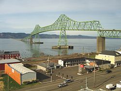
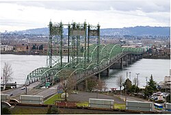
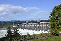
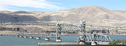
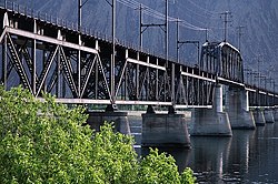
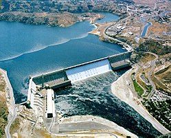
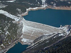
Photo Crossing River mile Carries Location Coordinates Astoria-Megler Bridge 13.5 [ 1] US 101 Astoria, Oregon Megler, Washington 46°13′02″N 123°51′47″W / 46.217222°N 123.863056°W / 46.217222; -123.863056 (Astoria-Megler Bridge ) Wahkiakum County Ferry 43.2 SR 409 Westport, Oregon Puget Island, Washington 46°08′12″N 123°22′41″W / 46.13675°N 123.378028°W / 46.13675; -123.378028 (Wahkiakum County Ferry ) Julia Butler Hansen Bridge n/a [ 2] SR 409 Puget Island, Washington Cathlamet, Washington 46°11′57″N 123°22′56″W / 46.19929°N 123.382323°W / 46.19929; -123.382323 (Julia Butler Hansen Bridge ) Lewis and Clark Bridge 66.0 SR 433 Longview, Washington Rainier, Oregon 46°06′17″N 122°57′42″W / 46.10472°N 122.961774°W / 46.10472; -122.961774 (Lewis and Clark Bridge ) Burlington Northern Railroad Bridge 9.6 105.6 BNSF Railway Portland, Oregon Vancouver, Washington 45°37′29″N 122°41′27″W / 45.624722°N 122.690833°W / 45.624722; -122.690833 (Burlington Northern Railroad Bridge 9.6 ) Interstate Bridge 106.5 I-5 45°37′05″N 122°40′30″W / 45.618068°N 122.675138°W / 45.618068; -122.675138 (Interstate 5 Bridge ) Glenn L. Jackson Memorial Bridge 112.7 I-205 45°35′35″N 122°32′55″W / 45.593056°N 122.548611°W / 45.593056; -122.548611 (Glenn L. Jackson Memorial Bridge ) Bonneville Dam 147.1 Lake Bonneville Bonneville, Oregon and North Bonneville, Washington 45°38′32″N 121°56′41″W / 45.642265°N 121.944792°W / 45.642265; -121.944792 (Bonneville Dam ) Bridge of the Gods 148.3 Pacific Crest Trail Cascade Locks, Oregon Stevenson, Washington 45°39′45″N 121°54′05″W / 45.662424°N 121.901276°W / 45.662424; -121.901276 (Bridge of the Gods ) Hood River Bridge 168.8 Hood River, Oregon White Salmon, Washington 45°43′05″N 121°29′43″W / 45.717976°N 121.495211°W / 45.717976; -121.495211 (Hood River Bridge ) The Dalles Bridge 191.3 US 197 The Dalles, Oregon Dallesport, Washington 45°36′36″N 121°08′21″W / 45.610136°N 121.139099°W / 45.610136; -121.139099 (The Dalles Bridge ) The Dalles Dam 191.5 Lake Celilo The Dalles, Oregon 45°36′46″N 121°07′55″W / 45.612868°N 121.132061°W / 45.612868; -121.132061 (The Dalles Dam ) Oregon Trunk Rail Bridge 200.0 BNSF Railway Sam Hill Memorial Bridge 208.2 US 97 Biggs Junction, Oregon Maryhill, Washington 45°40′34″N 120°50′11″W / 45.676143°N 120.836373°W / 45.676143; -120.836373 John Day Dam 215.6 Lake Umatilla 45°42′53″N 120°41′37″W / 45.714722°N 120.693611°W / 45.714722; -120.693611 (John Day Dam ) Umatilla Bridge 290.3 I-82 / US 395 Umatilla, Oregon Plymouth, Washington McNary Dam 292.0 Lake Wallula 45°55′47″N 119°17′46″W / 45.929722°N 119.296111°W / 45.929722; -119.296111 (McNary Dam ) Union Pacific Rail bridge 323.5 Union Pacific Railway 46°10′43″N 119°01′02″W / 46.17871°N 119.01731°W / 46.17871; -119.01731 BNSF Rail Bridge 328 BNSF Railway Pasco, Washington Kennewick, Washington Cable Bridge 328.5 SR 397 46°13′06″N 119°06′14″W / 46.218401°N 119.103813°W / 46.218401; -119.103813 (Cable Bridge ) Blue Bridge 330 US 395 46°13′10″N 119°06′15″W / 46.21955°N 119.10404°W / 46.21955; -119.10404 (Blue Bridge ) I-182 Bridge aka Lee-Volpentest Bridges 336 I-182 / US 12 Pasco, Washington Richland, Washington 46°15′50″N 119°14′45″W / 46.263917°N 119.245949°W / 46.263917; -119.245949 (Interstate 182 Bridge ) Vernita Bridge 388 SR 24 West of Hanford Site Mattawa Ropeway Conveyor Mattawa, Washington to West of Hanford Site 46°37′37″N 119°51′51″W / 46.62684°N 119.864298°W / 46.62684; -119.864298 (Mattawa Ropeway Conveyor ) Priest Rapids Dam 397.1 Priest Rapids Lake Beverly Railroad Bridge aka Milwaukee Road Bridge Former Chicago, Milwaukee, St. Paul and Pacific Railroad Beverly, Washington 46°49′52″N 119°56′54″W / 46.831111°N 119.948333°W / 46.831111; -119.948333 (Beverly Railroad Bridge ) Wanapum Dam 415.8 Lake Wanapum 46°52′31″N 119°58′16″W / 46.875213°N 119.971004°W / 46.875213; -119.971004 (Wanapum Dam ) Vantage Bridge I-90 Vantage, Washington 46°56′32″N 119°58′23″W / 46.942293°N 119.973106°W / 46.942293; -119.973106 (Vantage Bridge ) Rock Island Dam 453.4 Rock Island Pool 47°20′32″N 120°05′41″W / 47.342155°N 120.094773°W / 47.342155; -120.094773 (Rock Island Dam ) Rock Island Railroad Bridge BNSF Railway Rock Island, Washington 47°22′01″N 120°09′13″W / 47.366861°N 120.153722°W / 47.366861; -120.153722 (Rock Island Railroad Bridge ) Senator George Sellar Bridge SR 285 Wenatchee, Washington East Wenatchee, Washington Old Wenatchee Bridge Pedestrian, water pipeline Richard Odabashian Bridge US 2 / US 97 Rocky Reach Dam 473.7 Lake Entiat 47°32′00″N 120°17′40″W / 47.533264°N 120.294424°W / 47.533264; -120.294424 (Rocky Reach Dam ) Beebe Bridge US 97 Chelan, Washington Wells Dam 515.1 Lake Pateros 47°56′43″N 119°51′58″W / 47.9454°N 119.866°W / 47.9454; -119.866 (Wells Dam ) Brewster Bridge SR 173 Brewster, Washington Bridgeport Bridge SR 17 Bridgeport, Washington Chief Joseph Dam 545.1 Rufus Woods Lake 47°59′43″N 119°38′00″W / 47.995206°N 119.63321°W / 47.995206; -119.63321 (Chief Joseph Dam ) Grand Coulee Bridge SR 155 Coulee Dam, Washington Grand Coulee Dam 596.6 Franklin D. Roosevelt Lake 47°57′24″N 118°59′00″W / 47.956667°N 118.983333°W / 47.956667; -118.983333 (Grand Coulee Dam ) Keller-Wilbur Ferry SR 21 Keller, Washington Wilbur, Washington Gifford-Inchelium Ferry Gifford, Washington Inchelium, Washington Kettle Falls Bridges US 395 / SR 20 BNSF Railway Kettle Falls, Washington Northport Bridge SR 25 Northport, Washington Trail Bridge Highway 3B / Highway 22A Trail, British Columbia Kinnaird Bridge Highway 3 ( Crowsnest Highway ) Castlegar, British Columbia Rail bridge Canadian Pacific Railway Castlegar, British Columbia Robson, British Columbia Castlegar-Robson Bridge Broadwater Road Keenleyside Dam 780.0 North of Castlegar, British Columbia Needles Cable Ferry Highway 6 Needles, British Columbia Fauquier, British Columbia Arrow Park Ferry West Arrow Park East Arrow Park Upper Arrow Lake Ferry Highway 23 Galena Bay, British Columbia Shelter Bay, British Columbia Big Eddy Bridge Big Eddy Road Revelstoke, British Columbia Rail bridge Canadian Pacific Railway Revelstoke Bridge Highway 1 ( Trans-Canada Highway ) / Highway 23 Revelstoke Dam 934.0 Revelstoke Lake Mica Dam 1018.0 Mica Creek, British Columbia 52°04′34″N 118°33′59″W / 52.076117°N 118.566404°W / 52.076117; -118.566404 Boat Encampment ferry Boat Encampment Boat Encampment bridge Big Bend Highway Rail bridge Canadian Pacific Railway Donald, British Columbia Donald ferry Donald highway bridge Highway 1 ( Trans-Canada Highway ) Kicking Horse Drive Bridge Kicking Horse Drive Golden, British Columbia Canyon Creek Bridge Nicholson, British Columbia Parson bridge Parson River Crossing Road Parson, British Columbia Parson ferry Spillimacheen bridge Westside Road Spillimacheen, British Columbia Spillimacheen ferry Botts Channel Bridge Brisco Road Brisco, British Columbia Brisco Road bridge Brisco Road Brisco ferry Forsters Landing Bridge Forsters Landing Road Radium Hot Springs, British Columbia 50°37′26″N 116°06′23″W / 50.62376624°N 116.10639095°W / 50.62376624; -116.10639095 Athalmer bridge Athalmer Road Athalmer, British Columbia 50°30′56″N 116°01′09″W / 50.515608°N 116.019303°W / 50.515608; -116.019303 Athalmer ferry Fairmont Bridge Highway 93 / Highway 95 Fairmont Hot Springs, British Columbia 50°19′25″N 115°51′59″W / 50.323552°N 115.8662818°W / 50.323552; -115.8662818