
Vantage is a census-designated place (CDP) in Kittitas County, Washington, United States. The population was 74 at the 2010 census.

Wanapum Dam is a run-of-the-river hydroelectric project located on the Columbia River downstream (south) from Vantage, Washington where Interstate 90 crosses the Columbia from Grant County into Kittitas County. It is owned by the Grant County Public Utility District. Its reservoir is named Lake Wanapum.

Priest Rapids Dam is a hydroelectric, concrete gravity dam; located on the Columbia River, between the Yakima Firing Range and the Hanford Nuclear Reservation, and bridges Yakima County and Grant County, in the U.S. state of Washington. The dam is 24 miles south of the town of Vantage, and 47 miles northwest of the city of Richland. It is located at mile marker 397.1 from the mouth of the Columbia. It is owned by the Grant County Public Utility District (PUD). Priest Rapids, for which the dam was named, are now submerged beneath the dam's reservoir.

Grand Coulee Dam is a concrete gravity dam on the Columbia River in the U.S. state of Washington, built to produce hydroelectric power and provide irrigation water. Constructed between 1933 and 1942, Grand Coulee originally had two powerhouses. The third powerhouse ("Nat"), completed in 1974 to increase energy production, makes Grand Coulee the largest power station in the United States by nameplate capacity at 6,809 MW.
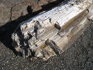
Ginkgo Petrified Forest State Park/Wanapum Recreational Area is a geologic preserve and public recreation area covering 7,124-acre (2,883 ha) on the western shoreline of the Columbia River's Wanapum Reservoir at Vantage, Washington. Petrified wood was discovered in the region in the early 1930s, which led to creation of the state park as a national historic preserve. Over 50 species are found petrified at the site, including ginkgo, sweetgum, redwood, Douglas-fir, walnut, spruce, elm, maple, horse chestnut, cottonwood, magnolia, madrone, sassafras, yew, and witch hazel.

Dworshak Dam is a concrete gravity dam in the western United States, on the North Fork of the Clearwater River in north central Idaho. In Clearwater County, the dam is located approximately four miles (6 km) northwest of Orofino and impounds the Dworshak Reservoir for flood control and hydroelectricity generation.

The Wanapum tribe of Native Americans formerly lived along the Columbia River from above Priest Rapids down to the mouth of the Snake River in what is now the US state of Washington. About 60 Wanapum still live near the present day site of Priest Rapids Dam. The name "Wanapum" is from the Sahaptin wánapam, meaning "river people", from wána, "river", and -pam, "people". Today they are enrolled in the federally recognized Confederated Tribes and Bands of the Yakama Nation.

State Route 26 (SR 26) is a state highway in central Washington in the United States. It travels east–west for 114 miles (183 km) from Interstate 90 (I-90) near Vantage to U.S. Route 195 (US 195) in Colfax. The highway intersects several major north–south highways, including SR 24, SR 17, US 395, and SR 261 before ending in Colfax. The route serves as a connector between Vantage, Royal City, Othello, Washtucna, La Crosse, and Colfax.

Priest Rapids was a narrow, fast-flowing stretch of the Columbia River, located in the central region of the U.S. state of Washington. It was flooded by the construction of the Priest Rapids Dam in the 1950s.

Keechelus Lake is a lake and reservoir in the northwest United States, near Hyak in Kittitas County, Washington. Approximately fifty miles (80 km) southeast of Seattle and a few miles southeast of Snoqualmie Pass, it is the source of the Yakima River.

Interstate 90 (I-90), designated as the American Veterans Memorial Highway, is a transcontinental Interstate Highway that runs from Seattle, Washington, to Boston, Massachusetts. It crosses Washington state from west to east, traveling 298 miles (480 km) from Seattle across the Cascade Mountains and into Eastern Washington, reaching the Idaho state line east of Spokane. I-90 intersects several of the state's other major highways, including I-5 in Seattle, I-82 and U.S. Route 97 (US 97) near Ellensburg, and US 395 and US 2 in Spokane.

The Snake River Bridge, is located on State Route 261 at the confluence of the Snake and Palouse Rivers, near Starbuck, Washington, USA. The bridge is listed on the National Register of Historic Places in 1982 and is located next to Lyons Ferry Park.

State Route 261 (SR 261) is a 62.71-mile-long (100.92 km) state highway in the U.S. state of Washington. Serving Columbia, Franklin, and Adams counties, the highway begins at U.S. Route 12 (US 12) east of Starbuck and becomes concurrent with SR 260 from Kahlotus to SR 26 in Washtucna before ending at Interstate 90 (I-90) and US 395 in Ritzville. The highway has been legislated since 1937 from Ritzville to Washtucna as Secondary State Highway 11E (SSH 11E) and in 1957 from Washtucna to the Starbuck area as a branch of SSH 11B. The two secondary highways became SR 261 during the 1964 highway renumbering, and a gap between Washtucna and Starbuck was not paved until the construction of the Snake River Bridge was completed in 1968.

State Route 243 (SR 243) is a state highway in Grant County, Washington. It travels north–south along the Columbia River for 28 miles (45 km), connecting SR 24 at the Vernita Bridge to SR 26 near Vantage. The highway travels through a predominantly rural and desert area, serving two hydroelectric dams and the communities of Desert Aire, Mattawa, and Beverly.

Wanapum Lake is a reservoir on the Columbia River in the U.S. state of Washington. It was created in 1963 with the construction of Wanapum Dam. It stretches from there upstream to the Rock Island Dam. The lake is named for the Wanapum people.
Priest Rapids Lake is a reservoir on the Columbia River in the U.S. state of Washington. It was created in 1959 with the construction of Priest Rapids Dam. The reservoir stretches from there upstream to the Wanapum Dam.
The following outline is provided as an overview of and topical guide to infrastructure of the U.S. state of Washington.

Sentinel Gap is a water gap formed by the Columbia River in the Saddle Mountains, near Mattawa in Washington state. The gap is "a water gap where erosion by the Columbia River was able to keep pace with folding, faulting and uplifting across the Saddle Mountain anticline". During Ice Age floods in which waters from the Channeled Scablands found passage to the Pacific Ocean here and at Wallula Gap, this opening was "repeatedly reamed out, which probably widened and steepened the walls of the gap". Strandlines from the floods can be seen on the basalt walls of the gap.

