The Kariba Dam is a double curvature concrete arch dam in the Kariba Gorge of the Zambezi river basin between Zambia and Zimbabwe. The dam stands 128 metres (420 ft) tall and 579 metres (1,900 ft) long. The dam forms Lake Kariba, which extends for 280 kilometres (170 mi) and holds 185 cubic kilometres (150,000,000 acre⋅ft) of water.

The Cowlitz River is a river in the state of Washington in the United States, a tributary of the Columbia River. Its tributaries drain a large region including the slopes of Mount Rainier, Mount Adams, and Mount St. Helens.

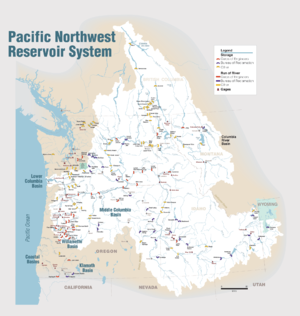
Rocky Reach Dam is a hydroelectric dam in the U.S. state of Washington owned and operated by Chelan County Public Utility District. It has 11 generators rated in total 1300 MW. The project is on the Columbia River in north central Washington state about seven miles (11 km) upstream from the city of Wenatchee. The dam is 473 miles (761 km) above the mouth of the Columbia. The reservoir impounded by the dam is Lake Entiat. The project provides energy for more than 7 million people throughout the Pacific Northwest.

Rock Island Dam is a hydroelectric dam on the Columbia River, in the U.S. state of Washington. Chelan County Public Utility District's Rock Island Dam and Hydro Project was the first dam to span the Columbia, having been built from 1929 to 1933. It is located near the geographical center of Washington, about 12 miles (19 km) downstream from the city of Wenatchee. By river, the dam is 235 miles (378 km) south of the Canada–US border and 453 miles (729 km) above the mouth of the river at Astoria, Oregon. The dam's reservoir is called Rock Island Pool.
Wells Dam is a hydroelectric dam located on the Columbia River, downstream from the confluence of the Okanogan River, Methow River, and the Columbia River in Washington state. The dam, associated structures, and machinery make up the Wells Hydroelectric Project. It is owned and operated by Douglas County Public Utility District.

Priest Rapids Dam is a hydroelectric, concrete gravity dam; located on the Columbia River, between the Yakima Firing Range and the Hanford Nuclear Reservation, and bridges Yakima County and Grant County, in the U.S. state of Washington. The dam is 24 miles south of the town of Vantage, and 47 miles northwest of the city of Richland. It is located at mile marker 397.1 from the mouth of the Columbia. It is owned by the Grant County Public Utility District (PUD). Priest Rapids, for which the dam was named, are now submerged beneath the dam's reservoir.

Oroville Dam is an earthfill embankment dam on the Feather River east of the city of Oroville, California, in the Sierra Nevada foothills east of the Sacramento Valley. At 770 feet (235 m) high, it is the tallest dam in the U.S. and serves mainly for water supply, hydroelectricity generation and flood control. The dam impounds Lake Oroville, the second largest man-made lake in the state of California, capable of storing more than 3.5 million acre feet.
The Chelan County Public Utility District, or Chelan County PUD, provides electric, water, wastewater public utility and telecommunications services in Chelan County, in north-central Washington, USA.
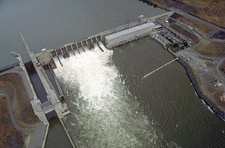
Ice Harbor Lock and Dam is a hydroelectric, concrete gravity run-of-the-river dam on the Snake River in Walla Walla and Franklin counties in the U.S. state of Washington. The dam is located 8 miles (13 km) northeast of the town of Burbank and 12 miles (19 km) east of Pasco, river mile 9.7. Its name comes from a tiny bay in the river where boats once tied up to wait for upstream ice-jams to break up.

Lake Chelan Dam officially known as the Lake Chelan Hydroelectric Project is located approximately 32 miles (51 km) north of the city of Wenatchee in Chelan County, near the geographic center of Washington state. The dam is located at the lower or southeasterly end of 50.4 miles long Lake Chelan, and is within the limits of the city of Chelan. The powerhouse is located near the community of Chelan Falls. The reservoir has 677,400 acre feet (835,600,000 m3) of usable water storage. The 10-year average generation for the Project is 365,000 megawatt hours.
Energy Northwest is a public power joint operating agency in the northwest United States, formed 64 years ago in 1957 by Washington state law to produce at-cost power for Northwest utilities. Headquartered in the Tri-Cities at Richland, Washington, the WPPSS became commonly known as "Whoops!," due to over-commitment to nuclear power in the 1970s which brought about financial collapse and the second largest municipal bond default in U.S. history. WPPSS was renamed Energy Northwest in November 1998, and agency membership includes 28 public power utilities, including 23 of the state's 29 public utility districts.

Condit Hydroelectric Project was a development on the White Salmon River in the U.S. state of Washington. It was completed in 1913 to provide electrical power for local industry and is listed in the National Register of Historic Places as an engineering and architecture landmark.
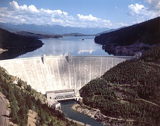
Hungry Horse Dam is an arch dam in the western United States, on the South Fork Flathead River in the Rocky Mountains of northwest Montana. It is located in Flathead National Forest in Flathead County, about fifteen miles (24 km) south of the west entrance to Glacier National Park, nine miles (14 km) southeast of Columbia Falls, and twenty miles (32 km) northeast of Kalispell. The Hungry Horse project, dam, and powerplant are operated by the U.S. Bureau of Reclamation. The entrance road leading to the dam is located in Hungry Horse.
Public Utility District No. 2 of Grant County, or Grant County PUD, is a public utility district in north central Washington state. It is owned by its customers and governed by a Board of Commissioners elected by the customer-owners. Though it is not regulated by another governmental unit, a PUD is, by state statute, a nonprofit corporation. PUDs must comply with state regulations for municipal corporations. The local customer-owner of the PUD receives benefits in the form of reduced rates for service. Grant County PUD operates two hydroelectric projects, Priest Rapids Dam and Wanapum Dam. In addition to these, the PUD also operates the Quincy Chute Hydroelectric Project, Potholes East Canal Headworks Project and part of the Nine Canyon Wind Project.
Snohomish County Public Utility District is a public utility providing power to over 350,000 customers in Snohomish County and on Camano Island, Washington. It provides water service to over 21,000 customers in the northeast section of the Snohomish County.

The Culmback Dam is a large rockfill hydroelectric and water supply dam on the Sultan River, a tributary of the Skykomish River, in Washington. Built in 1965, the dam is 640 feet (200 m) long at the crest and 262 feet (80 m) high. Its reservoir, Spada Lake, provides water for 70 to 75 percent of Snohomish County and feeds the Jackson Hydro Project, providing 112 megawatts of clean energy to Snohomish county. Some critics charge that the dam has strongly impacted the runs of salmon and other migratory fish in the Sultan River by depleting gravel and sediment needed to line the riverbed. The dam's operator counters that Culmback Dam dramatically reduces flooding events, benefiting fish populations and the surrounding communities. The dam was named in honor of George Culmback, a former mayor of Everett.
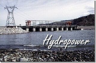
Hydroelectric power in the United States is, as of 2019, the second-largest renewable source of energy in both generation and nominal capacity. In 2019, hydroelectric power produced 38% of the total renewable electricity, and 6.6% of the total U.S. electricity.
The Enloe Dam, also known as the Similkameen Dam, and its powerplant are located on the Similkameen River about 4 miles (6.4 km) west-northwest of Oroville, Washington. Located just above Similkameen (Coyote) Falls, the concrete arch-gravity dam stands about 54 feet (16 m) high, with a crest length of about 290 feet (88 m), built between 1916 and 1923. The dam was named after the president of the Okanogan Valley Power Company, Eugene Enloe. The dam was operated to generate power at its powerplant, located about 850 feet (260 m) downstream from the dam. Lacking fish ladders, Enloe Dam blocks fish passage and completely extirpated anadromous fish migration into the upper reaches of the Similkameen River and its tributaries in Canada.
Moccasin Dam is a small dam on Moccasin Creek in Tuolumne County, California, in the town of Moccasin, west of Yosemite. It holds the Moccasin Reservoir. The dam, reservoir and associated hydroelectric power plant are part of the Hetch Hetchy Project, which provide water and power to the city of San Francisco. The dam is located near the junction of Highway 120 and Highway 49.

In February 2017, Oroville Dam's main and emergency spillways were damaged, prompting the evacuation of more than 180,000 people living downstream along the Feather River and the relocation of a fish hatchery.