Mica Dam was constructed by BC Hydro as part of three projects, along with Duncan Dam and Arrow Dam, required under the Columbia River Treaty, ratified in 1964. Construction began in 1967, and was completed on March 23, 1973.[1]
Mica Dam was operational on March 29, 1973.[9] The dam was built to a height of 244 metres (801ft) above bedrock, near the first location of the village Mica Creek. The dam operated with a 427km2 (165sqmi) reservoir containing 15km3 (12million acre-feet) of live storage and 24.8km3 (20.1million acre-feet) of total storage in McNaughton Lake, later renamed Kinbasket Lake in 1980.[10]
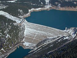
Mica Dam spillway
The underground powerhouse, begun in 1973, was built to be 54 metres (177ft) high, 24 metres (79ft) wide and 237 metres (778ft) long. In 1976, the first two electrical generators were commissioned, and in 1977 two more were completed bringing the total capacity of the powerhouse to 1,805 MW. Another two 500 MW generators were added and became operational in 2014 and in 2015, giving a total generating capacity of 2,805 MW.[3]
The Mica powerhouse delivers its power to Nicola Substation via a 500-kilovolt, 570-kilometre (350mi) transmission line. A second power transmission line was built to the Meridian Substation near Port Moody, British Columbia, Canada.
The creation of Kinbasket Lake submerged parts of the Big Bend Country, a subregion of the Columbia Country. This included a number of small communities along the Big Bend Highway, and the eastern section of that route.[1] Also, the Canadian Pacific Railway (CP) line ran along the Columbia Valley from Donald to Beavermouth. Consequently, west of Donald, CP diverted the line to a higher elevation, which required constructing four new bridges and a 336-metre (1,102ft) tunnel.[11]
Mica Dam was built to provide 8.6km3 (7million acre-feet) of water storage as outlined in the Columbia River Treaty, plus another 6.2km3 (5million acre-feet), referred to as "non-Treaty storage". Since 1977, BC Hydro and the Bonneville Power Administration (BPA) have made a series of long and short term agreements for using non-Treaty storage. Negotiations for a new long-term agreement began in 2011. If implemented, it would manage non-Treaty storage until 2024.[12]
Climate
Climate station located just south of Mica Dam at an elevation of 579.10 metres (1,899.9ft).[13]
Kinbasket Lake above Mica Dam normally has unused capacity to store water and Revelstoke Lake below the dam has minimal storage capacity. A proposed pumped storage addition on the side of Mica Dam would pump water into Kinbasket Lake, which would later be used to generate power at Mica and Revelstoke dams.[14] This project was discussed in 2017 as storage for intermittent power from wind turbines in the event that the Site C Dam was cancelled.
This page is based on this Wikipedia article Text is available under the CC BY-SA 4.0 license; additional terms may apply. Images, videos and audio are available under their respective licenses.