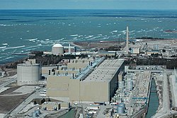
List of largest power stations in Canada

Last updated

Bruce Nuclear Generating Station in Bruce County, Ontario. Bruce-Nuclear-Szmurlo.jpg
Bruce Nuclear Generating Station in Bruce County, Ontario.

This article lists the largest electrical generating stations in Canada in terms of current installed electrical capacity. Non-renewable power stations are those that run on coal, fuel oils, nuclear, natural gas, oil shale and peat, while renewable power stations run on fuel sources such as biomass, geothermal heat, hydro, solar energy, solar heat, tides, waves and wind.

Contents

As of 2023 the largest power generating facility is the Bruce Nuclear Generating Station in Ontario and has an installed capacity of 6,610 MW.

Largest power stations

List of the electrical generating facilities in Canada with a current installed capacity of at least 250 MW.

RankNameProvinceStartup Location Capacity
(MW)
Annual Generation
(GWh)
TypeOwnerRef
1 Bruce Nuclear [note 1] Flag of Ontario.svg  Ontario 1977 44°19′31″N81°35′58″W / 44.32528°N 81.59944°W / 44.32528; -81.59944 (Bruce Nuclear) 6,61048,169 Nuclear (PHWR) Bruce Power [1] [2]
2 Robert-Bourassa Flag of Quebec.svg  Quebec 1979 53°46′55″N77°31′58″W / 53.78194°N 77.53278°W / 53.78194; -77.53278 (Robert-Bourassa) 5,61631,000 Hydro Hydro-Québec [3]
3 Churchill Falls Flag of Newfoundland and Labrador.svg  Newfoundland and Labrador 1971 53°31′32″N63°57′25″W / 53.52556°N 63.95694°W / 53.52556; -63.95694 (Churchill Falls) 5,42835,000 Hydro NL Hydro [4] [5]
4 Darlington Nuclear [note 2] Flag of Ontario.svg  Ontario 1990 43°52′22″N78°43′11″W / 43.87278°N 78.71972°W / 43.87278; -78.71972 (Darlington Nuclear) 3,51228,000 Nuclear (PHWR) OPG [6]
5 Pickering Nuclear [note 3] Flag of Ontario.svg  Ontario 1971 43°48′42″N79°03′57″W / 43.81167°N 79.06583°W / 43.81167; -79.06583 (Pickering Nuclear) 3,09420,000 Nuclear (PHWR) OPG [8]
6 Gordon M. Shrum Flag of British Columbia.svg  British Columbia 1968 56°0′58″N122°12′19″W / 56.01611°N 122.20528°W / 56.01611; -122.20528 (W. A. C. Bennett Dam) 2,90715,000 Hydro BC Hydro [9]
7 Mica Flag of British Columbia.svg  British Columbia 1973 52°4′35″N118°34′0″W / 52.07639°N 118.56667°W / 52.07639; -118.56667 (Mica Dam) 2,8057,202 Hydro BC Hydro [10] [9]
8 La Grande-4 Flag of Quebec.svg  Quebec 1984 53°53′12″N73°27′55″W / 53.88667°N 73.46528°W / 53.88667; -73.46528 (La Grande-4) 2,77914,600 Hydro Hydro-Québec [3]
9 Revelstoke Dam Flag of British Columbia.svg  British Columbia 1984 51°3′15″N118°11′40″W / 51.05417°N 118.19444°W / 51.05417; -118.19444 (Revelstoke Dam) 2,4807,800 Hydro BC Hydro [9]
10 La Grande-3 Flag of Quebec.svg  Quebec 1984 53°43′40″N75°59′55″W / 53.72778°N 75.99861°W / 53.72778; -75.99861 (La Grande-3) 2,41812,300 Hydro Hydro-Québec [3]
11 Lennox Flag of Ontario.svg  Ontario 1976 44°8′46″N76°51′9″W / 44.14611°N 76.85250°W / 44.14611; -76.85250 (Lennox) 2,14050 Natural gas or Fuel oil OPG [11]
12 La Grande-2-A Flag of Quebec.svg  Quebec 1992 53°46′46″N77°32′57″W / 53.77944°N 77.54917°W / 53.77944; -77.54917 (La Grande-2-A) 2,10611,600 Hydro Hydro-Québec [3]
13 Sundance Flag of Alberta.svg  Alberta 1970 53°30′27″N114°33′26″W / 53.50750°N 114.55722°W / 53.50750; -114.55722 (Sundance) 1,861 ? Natural gas TransAlta [12]
14 Beauharnois Flag of Quebec.svg  Quebec 1961 45°18′51″N73°54′37″W / 45.31417°N 73.91028°W / 45.31417; -73.91028 (Beauharnois) 1,85311,700 Hydro (ROR) Hydro-Québec [3]
15 Daniel-Johnson Flag of Quebec.svg  Quebec 1970 50°38′23″N68°43′37″W / 50.63972°N 68.72694°W / 50.63972; -68.72694 (Manic-5) 1,5967,400 Hydro Hydro-Québec [3]
16 Sir Adam Beck II Flag of Ontario.svg  Ontario 1954 43°08′45″N79°02′41″W / 43.1459°N 79.0446°W / 43.1459; -79.0446 (Sir Adam Beck II) 1,5162,149 Hydro OPG [13] [14]
17 La Grande-1 Flag of Quebec.svg  Quebec 1995 53°44′04″N78°34′26″W / 53.73444°N 78.57389°W / 53.73444; -78.57389 (La Grande-1) 1,4367,900 Hydro (ROR) Hydro-Québec [3]
18 Limestone Flag of Manitoba.svg  Manitoba 1990 56°30′25″N94°6′25″W / 56.50694°N 94.10694°W / 56.50694; -94.10694 (Limestone) 1,3509,000 Hydro (ROR) Manitoba Hydro [15]
19 René-Lévesque Flag of Quebec.svg  Quebec 1976 49°44′25″N68°35′34″W / 49.74028°N 68.59278°W / 49.74028; -68.59278 (René-Lévesque) 1,3265,400 Hydro (ROR) Hydro-Québec [3]
20 Genesee Flag of Alberta.svg  Alberta 1989 53°20′35″N114°18′11″W / 53.34306°N 114.30306°W / 53.34306; -114.30306 (Genesee) 1,286 ? Coal (81%)
Natural gas (19%)
Capital Power (83.3%)
TransAlta (16.7%)
[16] [17]
21 Keephills Flag of Alberta.svg  Alberta 1983 53°26′54″N114°27′02″W / 53.44833°N 114.45056°W / 53.44833; -114.45056 (Keephills) 1,240 ? Coal and

Natural gas

TransAlta (83.3%)
Capital Power (16.7%)
[18] [19]
22 Jean-Lesage Flag of Quebec.svg  Quebec 1967 49°19′18″N68°20′49″W / 49.32167°N 68.34694°W / 49.32167; -68.34694 (Jean-Lesage) 1,229 ? Hydro (ROR) Hydro-Québec [3]
23 Kettle Flag of Manitoba.svg  Manitoba 1973 56°23′3″N94°37′54″W / 56.38417°N 94.63167°W / 56.38417; -94.63167 (Kettle) 1,2208,500 Hydro (ROR) Manitoba Hydro [15]
24 Bersimis-1 Flag of Quebec.svg  Quebec 1956 49°18′31″N69°33′50″W / 49.30861°N 69.56389°W / 49.30861; -69.56389 (Bersimis-1) 1,178 ? Hydro Hydro-Québec [3]
25 Manic-5-PA Flag of Quebec.svg  Quebec 1970 50°38′26″N68°44′13″W / 50.64056°N 68.73694°W / 50.64056; -68.73694 (Manic-5-PA) 1,064 ? Hydro Hydro-Québec [3]
26 R. H. Saunders Flag of Ontario.svg  Ontario 1958 45°00′28″N74°47′34″W / 45.0077°N 74.7929°W / 45.0077; -74.7929 (R.H. Saunders) 1,045 ? Hydro OPG [20]
27 Outardes-3 Flag of Quebec.svg  Quebec 1969 49°33′33″N68°43′58″W / 49.55917°N 68.73278°W / 49.55917; -68.73278 (Outardes-3) 1,026 ? Hydro (ROR) Hydro-Québec [3]
28 Greenfield Flag of Ontario.svg  Ontario 2008 42°45′44″N82°27′09″W / 42.7622°N 82.4525°W / 42.7622; -82.4525 (Greenfield) 1,005 ? Natural gas Calpine (50%)
Mitsui (50%)
[21]
29 Long Spruce Flag of Manitoba.svg  Manitoba 1979 56°24′1″N94°22′10″W / 56.40028°N 94.36944°W / 56.40028; -94.36944 (Long Spruce) 9807,100 Hydro (ROR) Manitoba Hydro [15]
30 Coleson Cove Flag of New Brunswick.svg  New Brunswick 1976 45°09′13″N66°12′11″W / 45.15361°N 66.20306°W / 45.15361; -66.20306 (Coleson Cove) 1050 ? Fuel oil NB Power [22]
31 Shipshaw Flag of Quebec.svg  Quebec 2002 48°26′54″N71°12′54″W / 48.44833°N 71.21500°W / 48.44833; -71.21500 (Shipshaw) 896 ? Hydro Rio Tinto [23]
32 Sainte-Marguerite-3 Flag of Quebec.svg  Quebec 2003 50°42′18″N66°46′47″W / 50.70500°N 66.77972°W / 50.70500; -66.77972 (SM-3) 8842,730 Hydro Hydro-Québec [3]
33 Laforge-1 Flag of Quebec.svg  Quebec 1994 54°10′14″N72°36′55″W / 54.17056°N 72.61528°W / 54.17056; -72.61528 (Laforge-1) 8784,500 Hydro Hydro-Québec [3]
34 Bersimis-2 Flag of Quebec.svg  Quebec 1959 49°10′02″N69°14′26″W / 49.16722°N 69.24056°W / 49.16722; -69.24056 (Bersimis-2) 869 ? Hydro (ROR) Hydro-Québec [3]
35 Goreway Flag of Ontario.svg  Ontario 2009 43°44′46″N79°40′48″W / 43.74611°N 79.68000°W / 43.74611; -79.68000 (Goreway) 839 ? Natural gas Sithe Global Power [24]
36 Muskrat Falls Flag of Newfoundland and Labrador.svg  Newfoundland and Labrador 2021 53°14′44″N60°46′22″W / 53.24556°N 60.77278°W / 53.24556; -60.77278 (Muskrat Falls) 8244,900 Hydro NL Hydro [25] [26] [27] [28]
37 Seven Mile Flag of British Columbia.svg  British Columbia 1979 49°1′47″N117°30′11″W / 49.02972°N 117.50306°W / 49.02972; -117.50306 (Seven Mile) 8053,400 Hydro BC Hydro [9]
38 Shepard Flag of Alberta.svg  Alberta 2015 50°58′15″N113°53′07″W / 50.9707°N 113.8852°W / 50.9707; -113.8852 (Shepard) 800 ? Natural gas Capital Power (50%)
ENMAX (50%)
[29]
39 Kemano Flag of British Columbia.svg  British Columbia 1954 53°33′48″N127°56′32″W / 53.56333°N 127.94222°W / 53.56333; -127.94222 (Kemano) 790 ? Hydro Rio Tinto [30]
40 Outardes-4 Flag of Quebec.svg  Quebec 1969 49°42′21″N68°54′24″W / 49.70583°N 68.90667°W / 49.70583; -68.90667 (Outardes-4) 785 ? Hydro Hydro-Québec [3]
41 Sheerness Flag of Alberta.svg  Alberta 1986 51°26′32″N111°47′32″W / 51.44222°N 111.79222°W / 51.44222; -111.79222 (Sheerness) 7805,500 Natural gas Heartland Generation (50%)
TransAlta (50%)
[31] [32]
42 Eastmain-1-A Flag of Quebec.svg  Quebec 52°10′47″N76°2′7″W / 52.17972°N 76.03528°W / 52.17972; -76.03528 (Eastmain-1-A) 7682,300 Hydro Hydro-Québec [3]
43 Carillon Flag of Quebec.svg  Quebec 1962 45°34′07″N74°23′01″W / 45.56861°N 74.38361°W / 45.56861; -74.38361 (Carillon) 753 ? Hydro (ROR) Hydro-Québec [3]
44 Chutes-des-Passes Flag of Quebec.svg  Quebec 49°50′26″N71°09′46″W / 49.84056°N 71.16278°W / 49.84056; -71.16278 (Chute-des-Passes) 750 ? Hydro Rio Tinto [23]
45 Peace Canyon Flag of British Columbia.svg  British Columbia 55°58′57″N121°59′34″W / 55.98250°N 121.99278°W / 55.98250; -121.99278 (Peace Canyon Dam) 6943,250 Hydro BC Hydro [9]
46 Halton Hills Flag of Ontario.svg  Ontario 2010 43°33′41″N79°50′42″W / 43.56139°N 79.84500°W / 43.56139; -79.84500 (Halton Hills) 683 ? Natural gas OPG [33] [34]
47 Mactaquac Flag of New Brunswick.svg  New Brunswick 1968 45°57′18″N66°52′03″W / 45.9550°N 66.8675°W / 45.9550; -66.8675 (Mactaquac) 6721,600 Hydro NB Power [22]
48 Point Lepreau Nuclear [note 4] Flag of New Brunswick.svg  New Brunswick 1983 45°04′10″N66°27′20″W / 45.06944°N 66.45556°W / 45.06944; -66.45556 (Point Lepreau) 6604,111 Nuclear (PHWR) NB Power [22]
49 Romaine-2 Flag of Quebec.svg  Quebec 2014 50°37′28″N63°11′39″W / 50.62444°N 63.19417°W / 50.62444; -63.19417 (Romaine-2) 6403,300 Hydro Hydro-Québec [37]
50 Queen Elizabeth Flag of Saskatchewan.svg  Saskatchewan 1959 52°5′43″N106°42′22″W / 52.09528°N 106.70611°W / 52.09528; -106.70611 (Queen Elizabeth) 634 ? Natural gas SaskPower [38]
51 Holyrood Flag of Newfoundland and Labrador.svg  Newfoundland and Labrador 1971 47°27′10″N53°05′43″W / 47.45278°N 53.09528°W / 47.45278; -53.09528 (Holyrood) 624.52,996 Fuel oil (80%)
Diesel (20%)
NL Hydro [39] [40]
52 Lingan Flag of Nova Scotia.svg  Nova Scotia 1979 46°14′12″N60°2′14″W / 46.23667°N 60.03722°W / 46.23667; -60.03722 (Lingan) 6202,288 Coal Nova Scotia Power [41]
53 Bay d'Espoir Flag of Newfoundland and Labrador.svg  Newfoundland and Labrador 1967 47°59′25″N55°47′59″W / 47.9902°N 55.7996°W / 47.9902; -55.7996 (Bay d'Espoir) 613.42,657 Hydro NL Hydro [42]
54 Kootenay Canal Flag of British Columbia.svg  British Columbia 1976 49°27′10″N117°30′55″W / 49.45278°N 117.51528°W / 49.45278; -117.51528 (Kootenay Canal) 5832,482 Hydro BC Hydro [9]
55 Poplar River [note 5] Flag of Saskatchewan.svg  Saskatchewan 1981 49°3′27″N105°28′59″W / 49.05750°N 105.48306°W / 49.05750; -105.48306 (Poplar River) 582 ? Coal SaskPower [44]
56 Brighton Beach Flag of Ontario.svg  Ontario 2004 42°16′47″N83°05′42″W / 42.27972°N 83.09500°W / 42.27972; -83.09500 (Brighton Beach) 580 ? Natural gas ATCO Power (50%)
OPG (50%)
[45]
57 St. Clair Flag of Ontario.svg  Ontario 2009 42°53′47″N82°23′54″W / 42.89639°N 82.39833°W / 42.89639; -82.39833 (St. Clair) 577 ? Natural gas Invenergy [46]
58 Bécancour (TC Energy)Flag of Quebec.svg  Quebec 2006 46°22′2″N72°24′15″W / 46.36722°N 72.40417°W / 46.36722; -72.40417 (Bécancour (TC Energy)) 550 ? Natural gas TC Energy [47]
59 Portlands Flag of Ontario.svg  Ontario 2008 43°38′58″N79°19′51″W / 43.64944°N 79.33083°W / 43.64944; -79.33083 (Portlands) 550 ? Natural gas OPG [48] [34]
60 Battle River Flag of Alberta.svg  Alberta 1969 52°28′08″N112°08′02″W / 52.46889°N 112.13389°W / 52.46889; -112.13389 (Battle River) 540 ? Coal (50%)
Natural gas (50%)
ATCO Power [49]
60 Boundary Dam Flag of Saskatchewan.svg  Saskatchewan 1959 49°5′47″N103°1′49″W / 49.09639°N 103.03028°W / 49.09639; -103.03028 (Boundary Dam) 531 ? Coal SaskPower [44]
61 Toulnustouc Flag of Quebec.svg  Quebec 2005 49°58′14″N68°09′34″W / 49.97056°N 68.15944°W / 49.97056; -68.15944 (Toulnustouc) 5262,600 Hydro Hydro-Québec [3]
62 Outardes-2 Flag of Quebec.svg  Quebec 1978 49°08′59″N68°24′17″W / 49.14972°N 68.40472°W / 49.14972; -68.40472 (Outardes-2) 523 ? Hydro (ROR) Hydro-Québec [3]
63 Sarnia Regional Flag of Ontario.svg  Ontario 2006 42°56′04″N82°26′17″W / 42.93444°N 82.43806°W / 42.93444; -82.43806 (Sarnia Regional) 506 ? Natural gas TransAlta [50]
64 Waneta Flag of British Columbia.svg  British Columbia 1954 49°00′15″N117°36′43″W / 49.0041°N 117.6119°W / 49.0041; -117.6119 (Waneta) 4901,980 Hydro Teck (67%)
BC Hydro (33%)
[51] [52]
65 Eastmain-1 Flag of Quebec.svg  Quebec 2012 52°10′54″N76°03′05″W / 52.18167°N 76.05139°W / 52.18167; -76.05139 (Eastmain-1) 4802,700 Hydro Hydro-Québec [3]
65 Joffre Flag of Alberta.svg  Alberta 2000 52°18′24″N113°33′16″W / 52.30667°N 113.55444°W / 52.30667; -113.55444 (Joffre) 480 ? Natural gas Heartland Generation (40%)
Capital Power (40%)
NOVA Chemicals (20%)
[53]
67 Grand Rapids Flag of Manitoba.svg  Manitoba 1957 53°9′29″N99°17′33″W / 53.15806°N 99.29250°W / 53.15806; -99.29250 (Grand Rapids) 4792,320 Hydro Manitoba Hydro [15]
68 Bridge River Flag of British Columbia.svg  British Columbia 1948 50°43′54″N122°14′33″W / 50.73167°N 122.24250°W / 50.73167; -122.24250 (Bridge River) 4782,500 Hydro BC Hydro [54]
69 Brisay Flag of Quebec.svg  Quebec 1993 54°27′16″N70°31′09″W / 54.45444°N 70.51917°W / 54.45444; -70.51917 (Brisay) 4692,300 Hydro Hydro-Québec [3]
70 Belledune Flag of New Brunswick.svg  New Brunswick 1993 47°54′21″N65°51′48″W / 47.905962°N 65.863468°W / 47.905962; -65.863468 (Belledune) 458 ? Coal NB Power [22]
71 Sir Adam Beck I Flag of Ontario.svg  Ontario 1922 43°08′57″N79°02′40″W / 43.1491°N 79.0445°W / 43.1491; -79.0445 (Sir Adam Beck I) 4463,040 [note 6] Hydro OPG [13]
72 Des Joachims Flag of Ontario.svg  Ontario 1950 46°10′52″N77°41′45″W / 46.1811°N 77.6958°W / 46.1811; -77.6958 (Des Joachims) 429 ? Hydro OPG [20]
73 Tufts Cove Flag of Nova Scotia.svg  Nova Scotia 1965 44°40′35″N63°35′46″W / 44.67639°N 63.59611°W / 44.67639; -63.59611 (Tufts Cove) 415 ? Fuel oil (71%)
Natural gas (29%)
Nova Scotia Power [41]
74 Bécancour (Hydro-Québec)Flag of Quebec.svg  Quebec 46°23′31″N72°21′8″W / 46.39194°N 72.35222°W / 46.39194; -72.35222 (Bécancour (Hydro-Québec)) 411 ? Natural gas Hydro-Québec [55] [56]
75 Isle-Maligne Flag of Quebec.svg  Quebec 1926 48°34′37″N71°38′05″W / 48.57694°N 71.63472°W / 48.57694; -71.63472 (Isle-Maligne) 402 ? Hydro Rio Tinto [23]
76 York Flag of Ontario.svg  Ontario 2012 44°04′32″N79°31′54″W / 44.07556°N 79.53167°W / 44.07556; -79.53167 (York) 400 ? Natural gas Capital Power (50%)
Unknown (50%)
[57]
77 Millbank Flag of New Brunswick.svg  New Brunswick 1991 47°04′26″N65°27′19″W / 47.07389°N 65.45528°W / 47.07389; -65.45528 (Millbank) 399 ? Fuel oil NB Power [22] [58]
78 Romaine-3 Flag of Quebec.svg  Quebec 2017 51°07′51″N63°24′49″W / 51.13086°N 63.41363°W / 51.13086; -63.41363 (Romaine-3) 395 ? Hydro Hydro-Québec
79 Péribonka Flag of Quebec.svg  Quebec 1952 49°30′28″N71°10′59″W / 49.50778°N 71.18306°W / 49.50778; -71.18306 (Peribonka) 3852,200 Hydro (ROR) Hydro-Québec [3]
80 McCormick Flag of Quebec.svg  Quebec 49°11′35″N68°19′37″W / 49.19306°N 68.32694°W / 49.19306; -68.32694 (McCormick) 367 ? Hydro Hydro-Québec (60%)
Alcoa (40%)
[3] [59]
81 Seigneurie de Beaupré Flag of Quebec.svg  Quebec 2013 47°22′20″N70°51′39″W / 47.3721°N 70.8609°W / 47.3721; -70.8609 (Seigneurie de Beaupré Wind Farm) 363.5 ? Wind Boralex (50%)
Énergir (46.8%)
La Côte-de-Beaupré (3.2%)
[60] [61]
82 Brazeau Flag of Alberta.svg  Alberta 52°57′59″N115°34′44″W / 52.96639°N 115.57889°W / 52.96639; -115.57889 (Brazeau) 355397 Hydro TransAlta [62]
83 Rivière-du-Moulin Flag of Quebec.svg  Quebec 2014 47°58′00″N71°01′00″W / 47.9667°N 71.0167°W / 47.9667; -71.0167 (Rivière-du-Moulin Wind Project) 350 ? Wind EDF Renewables [63]
84 Abitibi Flag of Ontario.svg  Ontario 1936 49°52′40″N81°34′15″W / 49.87778°N 81.57083°W / 49.87778; -81.57083 (Abitibi Canyon) 349 ? Hydro OPG [64]
85 Waneta Dam Expansion Flag of British Columbia.svg  British Columbia 2015 49°00′15″N117°36′42″W / 49.0041°N 117.6116°W / 49.0041; -117.6116 (Waneta Dam Expansion) 335627.4 Hydro Columbia Power (58%)
Columbia Basin Trust (42%)
86 Laforge-2 Flag of Quebec.svg  Quebec 1996 54°35′30″N71°16′15″W / 54.59167°N 71.27083°W / 54.59167; -71.27083 (Laforge-2) 3191,800 Hydro (ROR) Hydro-Québec [3]
87 Trenton Flag of Nova Scotia.svg  Nova Scotia 1969 45°37′13″N62°38′53″W / 45.62028°N 62.64806°W / 45.62028; -62.64806 (Trenton) 305 ? Coal Nova Scotia Power [41]
88 Trenche Flag of Quebec.svg  Quebec 47°45′12″N72°52′44″W / 47.75333°N 72.87889°W / 47.75333; -72.87889 (Trenche) 302 ? Hydro (ROR) Hydro-Québec [3]
89 Blackspring Ridge Flag of Alberta.svg  Alberta 2014 50°08′03″N112°54′55″W / 50.134124°N 112.915408°W / 50.134124; -112.915408 (Blackspring Ridge Wind Project) 300 ? Wind EDF Renewables [65]
89 Calgary Flag of Alberta.svg  Alberta 2003 51°10′49″N113°56′12″W / 51.1803°N 113.9368°W / 51.1803; -113.9368 (Calgary Energy Centre) 300 ? Natural gas Enmax [66]
89 Henvey Inlet Flag of Ontario.svg  Ontario 2019 45°58′35″N80°33′38″W / 45.97639°N 80.56056°W / 45.97639; -80.56056 (Henvey Inlet) 300 ? Wind Pattern Energy [67] [68]
89 Lac Alfred Flag of Quebec.svg  Quebec 2016 48°24′51″N67°41′15″W / 48.41417°N 67.68750°W / 48.41417; -67.68750 (Lac Alfred (Phase I) Wind Project) 300 ? Wind EDF Renewables [69]
93 La Tuque Flag of Quebec.svg  Quebec 1955 47°26′39″N72°47′58″W / 47.44417°N 72.79944°W / 47.44417; -72.79944 (La Tuque) 294 ? Hydro (ROR) Hydro-Québec [3]
94 E.B. Campbell Flag of Saskatchewan.svg  Saskatchewan 1963 53°41′19″N103°20′47″W / 53.6885°N 103.3465°W / 53.6885; -103.3465 (E.B. Campbell) 288900 Hydro SaskPower [70]
95 Kelsey Flag of Manitoba.svg  Manitoba 1961 56°2′21″N96°31′54″W / 56.03917°N 96.53167°W / 56.03917; -96.53167 (Kelsey) 2871,970 Hydro (ROR) Manitoba Hydro [15]
96 Bayside Flag of New Brunswick.svg  New Brunswick 45°16′30″N66°01′36″W / 45.27500°N 66.02667°W / 45.27500; -66.02667 (Bayside) 280 ? Natural gas NB Power [71]
97 Shand Flag of Saskatchewan.svg  Saskatchewan 1992 49°5′16″N102°51′49″W / 49.08778°N 102.86361°W / 49.08778; -102.86361 (Shand) 276 ? Coal SaskPower [44]
98 Island Flag of British Columbia.svg  British Columbia 2002 50°04′08″N125°16′55″W / 50.0689°N 125.2819°W / 50.0689; -125.2819 (Island) 275 ? Natural gas Capital Power [72]
99 Lower Notch Flag of Ontario.svg  Ontario 1971 47°08′20″N79°27′15″W / 47.1390°N 79.4541°W / 47.1390; -79.4541 (Lower Notch) 274 ? Hydro OPG [64]
100 Beaumont Flag of Quebec.svg  Quebec 1959 47°33′20″N72°50′12″W / 47.55556°N 72.83667°W / 47.55556; -72.83667 (Beaumont) 270 ? Hydro (ROR) Hydro-Québec [73]
100 Romaine-1 Flag of Quebec.svg  Quebec 2015 50°23′01″N63°15′37″W / 50.38361°N 63.26028°W / 50.38361; -63.26028 (Romaine-1) 270 ? Hydro (ROR) Hydro-Québec [73]
102 Smoky Falls Flag of Ontario.svg  Ontario 1931 50°03′40″N82°09′41″W / 50.06111°N 82.16139°W / 50.06111; -82.16139 (Smoky Falls) 267 ? Hydro OPG (75%)
Moose Cree (25%)
[74]
103 Thorold Flag of Ontario.svg  Ontario 2010 43°06′25″N79°11′55″W / 43.10694°N 79.19861°W / 43.10694; -79.19861 (Thorold) 265 ? Natural gas Northland Power [75]
104 Brandon Flag of Manitoba.svg  Manitoba 1958 49°50′44″N99°53′16″W / 49.84556°N 99.88778°W / 49.84556; -99.88778 (Brandon) 263 ? Natural gas Manitoba Hydro [15]
105 North Battleford Flag of Saskatchewan.svg  Saskatchewan 2013 52°41′00″N108°10′18″W / 52.6833°N 108.1717°W / 52.6833; -108.1717 (North Battleford) 260 ? Natural gas Northland Power [76]
106 Nipawin Flag of Saskatchewan.svg  Saskatchewan 1985 53°19′11″N104°2′31″W / 53.31972°N 104.04194°W / 53.31972; -104.04194 (Nipawin) 255 ? Hydro SaskPower [77]

Notes

  1. Uprated from 6,408 MW to 6,550 MW in October of 2021 with an added 60 MW from Unit 2 in 2022 taking the total to 6610MW, with a target capacity of 7,000 MW by mid-2033.
  2. Refurbishment to be completed by 2026.
  3. To be decommissioned by 31 December 2024. [7]
  4. A 100 MW small modular reactor was approved in December 2019. Upon completion of the reactor in 2028, Point Lepreau will have an installed capacity of 760 MW. [35] [36]
  5. To be decommissioned by 2030. [43]
  6. Estimated from the published total annual generation of the two Sir Adam Beck stations, weighted by their relative nameplate capacities [13]

Largest power stations under construction

List of the electrical generating facilities under construction in Canada with an expected installed capacity of at least 250 MW.

RankNameProvince Location Capacity (MW)TypeOwnerYearRef
1 Napanee Flag of Ontario.svg  Ontario 44°08′53″N76°50′31″W / 44.14806°N 76.84194°W / 44.14806; -76.84194 (Napanee (Under construction)) 900 Natural gas OPG On Hold [34]
2 Keeyask Flag of Manitoba.svg  Manitoba 56°20′47″N95°12′17″W / 56.34639°N 95.20472°W / 56.34639; -95.20472 (Keeyask (Under construction)) 695 Hydro Manitoba Hydro 2021 [78]
3 Site C dam Flag of British Columbia.svg  British Columbia 56°11′41″N120°54′51″W / 56.19472°N 120.91417°W / 56.19472; -120.91417 (Site C (Under construction)) 1,100 Hydro BC Hydro 2024 [79]

Largest decommissioned power stations

List of former electrical generating facilities in Canada that had an installed capacity of at least 250 MW at the time of their decommissioning. Only facilities that have permanently shut down all of their electricity generating units are included.

NameImageProvince Location Capacity
(MW)
TypeOwnerYearsYears in
service
Smokestack
configuration
[80] [ circular reference ]
Nanticoke Nanticoke Generating Station 2.jpg Flag of Ontario.svg  Ontario 42°48′0″N80°3′1″W / 42.80000°N 80.05028°W / 42.80000; -80.05028 (Nanticoke (Demolished)) 3,964 Coal OPG 1973-201340 years198 m (650 ft) ×2
Lakeview Lakeview GS-1.jpg Flag of Ontario.svg  Ontario 43°34′16″N79°33′6″W / 43.57111°N 79.55167°W / 43.57111; -79.55167 (Lakeview (Demolished)) 2,400 Coal OPG 1962-2005
43 years150 m (492 ft) ×4
Lambton Lambton GS.JPG Flag of Ontario.svg  Ontario 42°47′50″N82°28′10″W / 42.79722°N 82.46944°W / 42.79722; -82.46944 (Lambton (Decommissioned)) 1,976 Coal OPG 1969-201344 years168 m (550 ft) ×3
Hearn Hearn Generating Station.jpg Flag of Ontario.svg  Ontario 43°38.730′N79°20.105′W / 43.645500°N 79.335083°W / 43.645500; -79.335083 1,200 Coal OPG 1951-198332 years215 m (705 ft) ×1
Gentilly Nuclear Centrale nucleaire Gentilly.jpg Flag of Quebec.svg  Quebec 46°23′45″N72°21′25″W / 46.39583°N 72.35694°W / 46.39583; -72.35694 (Gentilly Nuclear (Decommissioned)) 925 Nuclear
(SGHWR, PHWR)
Hydro-Québec 1983-201229 yearsna
Wabamun Flag of Alberta.svg  Alberta 53°33′30″N114°29′17″W / 53.55833°N 114.48806°W / 53.55833; -114.48806 (Wabamun (Demolished)) 582 Coal TransAlta 1956-201054 years156 (512 ft) ×3
Dalhousie Flag of New Brunswick.svg  New Brunswick 48°03′07″N66°22′15″W / 48.051919°N 66.370770°W / 48.051919; -66.370770 (Dalhousie (Demolished)) 315 Coal NB Power 1967-201245 years167 m (551 ft) & 162 m (532 ft)
Thunder Bay ThunderBayCoalGenStn.jpg Flag of Ontario.svg  Ontario 48°21′36″N89°13′12″W / 48.36000°N 89.22000°W / 48.36000; -89.22000 (Thunder Bay (Decommissioned)) 306 Coal (1963-2014)
Biomass (2015-2018)
OPG 1963-2018 [81] 55 years198 m (650 ft) & 107 m (350 ft)

See also

Map all coordinates using: OpenStreetMap

Related Research Articles

<span class="mw-page-title-main">Pickering Nuclear Generating Station</span> Nuclear power plant in Canada

Pickering Nuclear Generating Station is a Canadian nuclear power station located on the north shore of Lake Ontario in Pickering, Ontario. It is one of the oldest nuclear power stations in the world and Canada's third-largest, with eight CANDU reactors. Since 2003, two of these units have been defueled and deactivated. The remaining six produce about 16% of Ontario's power and employ 3,000 workers.

<span class="mw-page-title-main">NB Power</span> Electric utility company

New Brunswick Electric Power Corporation, operating as NB Power, is the primary electric utility in the Canadian province of New Brunswick. NB Power is a vertically-integrated Crown corporation by the government of New Brunswick and is responsible for the generation, transmission, and distribution of electricity. NB Power serves all the residential and industrial power consumers in New Brunswick, with the exception of those in Saint John, Edmundston and Perth-Andover who are served by Saint John Energy, Energy Edmundston, and the Perth-Andover Electric Light Commission, respectively.

<span class="mw-page-title-main">Electricity sector in Canada</span>

The electricity sector in Canada has played a significant role in the economic and political life of the country since the late 19th century. The sector is organized along provincial and territorial lines. In a majority of provinces, large government-owned integrated public utilities play a leading role in the generation, transmission, and distribution of electricity. Ontario and Alberta have created electricity markets in the last decade to increase investment and competition in this sector of the economy.

<span class="mw-page-title-main">Nanticoke Generating Station</span> Former coal-fired power station in Nanticoke, Ontario, Canada

The Nanticoke Generating Station was a coal-fired power station in Nanticoke, Ontario in operation from 1972 to 2013. It was the largest coal power station in North America and, at full capacity, it could provide 3,964 MW of power into the southern Ontario power grid from its base in Nanticoke, Ontario, Canada, and provided as much as 15% of Ontario's electricity.

<span class="mw-page-title-main">Hydro-Québec's electricity transmission system</span> International power transmission system centred in Quebec, Canada

Hydro-Québec's electricity transmission system is an international electric power transmission system centred in Quebec, Canada. The system pioneered the use of very high voltage 735-kilovolt (kV) alternating current (AC) power lines that link the population centres of Montreal and Quebec City to distant hydroelectric power stations like the Daniel-Johnson Dam and the James Bay Project in northwestern Quebec and the Churchill Falls Generating Station in Labrador.

<span class="mw-page-title-main">Ontario Power Generation</span> Electric utility company in Canada

Ontario Power Generation Inc. (OPG) is a Crown corporation and "government business enterprise" that is responsible for approximately half of the electricity generation in the province of Ontario, Canada. It is wholly owned by the government of Ontario. Sources of electricity include nuclear, hydroelectric, wind, gas and biomass. Although Ontario has an open electricity market, the provincial government, as OPG's sole shareholder, regulates the price the company receives for its electricity to be less than the market average, in an attempt to stabilize prices. Since 1 April 2008, the company's rates have been regulated by the Ontario Energy Board.

According to the International Hydropower Association, Canada is the fourth largest producer of hydroelectricity in the world in 2021 after the United States, Brazil, and China. In 2019, Canada produced 632.2 TWh of electricity with 60% of energy coming from Hydroelectric and Tidal Energy Sources).

Brookfield Renewable Partners L.P. is a publicly traded limited partnership that owns and operates renewable power assets, with corporate headquarters in Toronto, Ontario, Canada. It is 60% owned by Brookfield Asset Management.

<span class="mw-page-title-main">Hydroelectricity in the United Kingdom</span>

As of 2018, hydroelectric power stations in the United Kingdom accounted for 1.87 GW of installed electrical generating capacity, being 2.2% of the UK's total generating capacity and 4.2% of UK's renewable energy generating capacity. This includes four conventional hydroelectric power stations and run-of-river schemes for which annual electricity production is approximately 5,000 GWh, being about 1.3% of the UK's total electricity production. There are also four pumped-storage hydroelectric power stations providing a further 2.8 GW of installed electrical generating capacity, and contributing up to 4,075 GWh of peak demand electricity annually.

Smoky Falls Generating Station is one of four stations in the Lower Mattagami River Hydroelectric Complex owned by Ontario Power Generation (OPG) and the Moose Cree First Nation. The station is approximately 85 km (53 mi) northeast of Kapuskasing in the Cochrane District of Northern Ontario. Smoky Falls was originally commissioned as a 54 MW generating station in 1931 by the Spruce Falls Power and Paper Company but it was sold to OPG's predecessor, Ontario Hydro, in 1991. OPG completed a $2.6 billion upgrade of the four Lower Mattagami dams in 2014 and 2015. The new Smoky Falls was commissioned in late 2014 with a 267.9 MW installed capacity.

Kipling Generating Station is one of four stations in the Lower Mattagami River Hydroelectric Complex. The station is jointly owned by Ontario Power Generation and the Moose Cree First Nation (25%). The station is approximately 95 km (59 mi) northeast of Kapuskasing in the Cochrane District of Northern Ontario and is the last of four stations in OPG's Lower Mattagami River complex. Kipling GS was originally commissioned as a 2-unit, 155 MW generating station in 1966 by OPG's predecessor, Ontario Hydro. OPG completed a $2.6 billion construction project covering the four Lower Mattagami dams in 2014 and 2015, and added a third generating unit with 78.3 MW capacity to Kipling GS, bringing the total station capacity to 233.3 MW.

References

  1. Bruce Power (July 2007), A Reporter's Guide to Bruce Power (PDF), archived from the original (PDF) on 2010-04-01, retrieved 2010-08-22
  2. "Bruce Power increases output though innovation and efficiency". Bruce Power. Retrieved 30 November 2019.
  3. 1 2 3 4 5 6 7 8 9 10 11 12 13 14 15 16 17 18 19 20 21 22 23 24 25 26 27 Hydro-Québec Production (2014), Hydroelectric Generating Stations (as of November 11, 2014), Hydro-Québec, retrieved 2015-10-17
  4. Nalcor Energy, Churchill Falls , retrieved 2010-08-24
  5. Hydro-Québec (April 2010), Shaping The Future : Annual Report 2009 (PDF), Montreal, p. 52, ISBN   978-2-550-58101-7, ISSN   0702-6706, archived from the original (PDF) on 2011-06-05, retrieved 2010-04-08{{citation}}: CS1 maint: location missing publisher (link)
  6. Ontario Power Generation, Darlington Nuclear, archived from the original on 2009-03-26, retrieved 2010-08-22
  7. "Ontario government supports OPG proposal to operate Pickering nuclear station past planned 2024 closing" . Retrieved 2020-01-19.
  8. Ontario Power Generation, Pickering Nuclear, archived from the original on 2010-09-12, retrieved 2010-08-22
  9. 1 2 3 4 5 6 BCHydro (June 2017), Quick Facts for the Year Ended March 31, 2017 (PDF), retrieved 2018-04-28
  10. Mica Projects: February 2015 Project Update (PDF) (Report). BC Hydro. p. 1. Retrieved 12 October 2023.
  11. Ontario Power Generation, Lennox Generating Station, archived from the original on 2008-12-07, retrieved 2010-08-21
  12. "Sundance". TransAlta. 2018. Archived from the original on 1 September 2019. Retrieved 24 January 2020.
  13. 1 2 3 Ontario Power Generation, OPG's Sir Adam Beck I hydro station celebrates a century of clean power, archived from the original on 2022-08-29, retrieved 2022-08-29
  14. "Two new, efficient units set to boost clean power output at Sir Adam Beck 1 Hydroelectric Station".
  15. 1 2 3 4 5 6 ManitobaHydro (2015), Your Energy: Manitoba Hydro-Electric Board 64th Annual Report For the Year Ended March 31, 2015 (PDF), Winnipeg: ManitobaHydro, p. 93, archived from the original (PDF) on 2016-03-04, retrieved 2015-10-18
  16. Capital Power Corporation, Genesee Unit 1 and 2, archived from the original on 2012-04-21, retrieved 2012-02-28
  17. Capital Power Corporation, Genesee 3, archived from the original on 2010-05-04, retrieved 2010-08-22
  18. TransAlta (May 23, 2014), Keephills , retrieved 2015-10-18
  19. Capital Power Corporation (September 1, 2011). "Keephills 3". Archived from the original on April 21, 2012. Retrieved 2012-02-28.
  20. 1 2 Ontario Power Generation, Ottawa / St. Lawrence Plant Group, archived from the original on 2010-07-29, retrieved 2010-08-23
  21. "Calpine | Greenfield Energy Centre". www.calpine.com. Retrieved 2020-01-19.
  22. 1 2 3 4 5 NB Power, System Map, archived from the original on 2008-12-22, retrieved 2010-08-22
  23. 1 2 3 Alcan (May 2005), Water Energy : The Management of Lac Saint-Jean (PDF), archived from the original (PDF) on 2011-07-07, retrieved 2010-08-23
  24. Ontario Power Authority, Goreway Station, archived from the original on 2014-07-25, retrieved 2011-01-13
  25. "Muskrat Falls Generating Project | Nalcor Energy – Lower Churchill Project" . Retrieved 2020-01-29.
  26. "Final Commissioning of Lower Churchill Project Delayed Again" . Retrieved 2022-01-31.
  27. "35-year hydro electricity supply set to flow into Nova Scotia" . Retrieved 2022-01-31.
  28. "Backgrounder - Quick Facts – Muskrat Falls Development Generation and Transmission" . Retrieved 2022-01-31.
  29. ENMAX, Shepard Energy Centre , retrieved 2015-10-17
  30. Rio Tinto Alcan, Power Operations/Watershed Management, archived from the original on 2010-07-29, retrieved 2010-08-27
  31. ATCO Power (October 1, 2015), Sheerness Thermal Generating Station , retrieved 2015-10-18
  32. TransAlta (August 21, 2009), Sheerness , retrieved 2015-10-18
  33. Ontario Power Authority, Halton Hills Generating Station, archived from the original on 2014-07-25, retrieved 2011-01-13
  34. 1 2 3 "Napanee gas plant sold in multi-billion dollar deal". Quinte News. Retrieved 2020-01-22.
  35. "N.B. makes step forward on second nuclear reactor at Point Lepreau". Atlantic. 2019-12-09. Retrieved 2020-01-19.
  36. "ARC-100 Reactor". ARC. Retrieved 2020-01-19.
  37. Hydro-Québec Production (2017). "Projet de la Romaine: En bref" (in French). Montréal: Hydro-Québec. Retrieved 2018-01-14.
  38. "Queen Elizabeth Power Station". www.saskpower.com. Retrieved 2020-01-28.
  39. "Thermal Generation". Newfoundland & Labrador Hydro. Retrieved 2020-01-22.
  40. "New combustion turbine at Holyrood running at full capacity". CBC. Retrieved 2022-02-03.
  41. 1 2 3 NS Power, NS Power Thermal Generating Facilities, archived from the original on 2011-07-06, retrieved 2010-08-22
  42. Newfoundland and LabradorHydro, Bay d'Espoir Hydroelectric Generating Facility, archived from the original on 2013-01-01, retrieved 2010-08-24
  43. McElroy, Daniel. "Impending Power Plant Closure Means Trying Times Ahead for Coronach". SwiftCurrentOnline.com. Retrieved 2020-02-12.
  44. 1 2 3 SaskPower, Baseload Thermal Stations, archived from the original on 2010-11-21, retrieved 2010-10-09
  45. ATCO Power, Brighton Beach Combined-Cycle Generating Station , retrieved 2015-10-18
  46. Ontario Power Authority, St. Clair Energy Centre, archived from the original on 2014-07-25, retrieved 2011-01-13
  47. "Bécancour Cogeneration Plant" (PDF). TC Energy. February 2018. Retrieved 21 January 2020.
  48. Portlands Energy Centre, Portlands Energy Centre Fact Sheet (PDF), archived from the original (PDF) on 2009-11-27, retrieved 2010-08-22
  49. "Demand". www.aer.ca. Retrieved 2020-02-03.
  50. Sarnia, January 17, 2011, retrieved 2015-10-18
  51. BC Hydro (17 June 2009), BC Hydro plans to purchase one-third interest in Waneta Dam, archived from the original on 11 June 2011, retrieved 2010-08-25
  52. Teck Resources Limited (5 March 2010), Teck Announces Waneta Dam Sale Closing, archived from the original on 2010-07-14, retrieved 2010-08-25
  53. ATCO Power, Joffre Cogeneration Plant, archived from the original on 2010-07-27, retrieved 2010-08-21
  54. BC Hydro Bridge River Recreation Info page
  55. Hydro-Québec Production (2011), Thermal generating stations, Hydro-Québec, retrieved 2011-05-17
  56. "Thermal generating stations | Hydro-Québec Production". www.hydroquebec.com. Retrieved 2020-01-19.
  57. IESO, York Energy Centre, archived from the original on 2014-07-10, retrieved 2015-10-17
  58. "Millbank OCGT Generating Station Canada - GEO". globalenergyobservatory.org. Retrieved 2020-01-20.
  59. Alcoa. "Manicouagan Power Station". Archived from the original on 2012-02-29. Retrieved 2012-02-28.
  60. Hydro-Québec Distribution. "Wind farms and generating stations covered by supply contracts" . Retrieved 2013-01-02.
  61. Téotonio, Jean-Manuel (November 29, 2013). "Mise en service des premières éoliennes dans la Seigneurie de Beaupré". L'Autre Voix (in French). Archived from the original on December 18, 2013. Retrieved 2013-12-28.
  62. "Brazeau". www.transalta.com . Retrieved 2017-12-26.
  63. EDF Energies Nouvelles commissions Rivière-du-Moulin, its largest wind farm (350 MW) Archived 2016-07-12 at the Wayback Machine . Retrieved 12. July 2016.
  64. 1 2 Ontario Power Generation (February 2010), OPG Generating Stations (PDF), archived from the original (PDF) on 2010-08-27, retrieved 2010-08-23
  65. "Blackspring Ridge Wind Project, Alberta". Power Technology | Energy News and Market Analysis. Retrieved 2019-10-13.
  66. Enmax, Calgary Energy Centre, archived from the original on 2011-07-10, retrieved 2010-08-22
  67. "Henvey Inlet Wind". Pattern Energy. Retrieved 2020-01-22.
  68. "Henvey Inlet Wind Power Project, Ontario, Canada". Power Technology | Energy News and Market Analysis. Retrieved 2020-01-22.
  69. "Lac-Alfred Wind | Saint-Cleophas & Sainte-Irene | Canada". EDF Renewables. Retrieved 2019-10-27.
  70. SaskPower, E.B. Campbell Hydroelectric Station, archived from the original on 2010-12-22, retrieved 2010-10-09
  71. "NB Power purchases Bayside Generating Station from Emera Energy Inc". www.nbpower.com. Retrieved 2020-01-22.
  72. "Island Generation". Capital Power. Retrieved 2020-01-22.
  73. 1 2 "Hydroelectric generating stations | Hydro-Québec Production". www.hydroquebec.com. Retrieved 2020-01-28.
  74. "OPG projects > Lower Mattagami River Project". OPG. Retrieved 2020-01-30.
  75. "Northland Power - Thorold". www.northlandpower.com. Retrieved 2020-01-28.
  76. "Northland Power - North Battleford". www.northlandpower.com. Retrieved 2020-01-28.
  77. "Nipawin Hydroelectric Station". www.saskpower.com. Retrieved 2019-10-19.
  78. "Keeyask Generating Station". www.hydro.mb.ca. Retrieved 2020-01-22.
  79. "Site C Backgrounder" (PDF). BC Hydro. 23 June 2016. Archived from the original (PDF) on 23 June 2016. Retrieved 29 April 2018.
  80. List of tallest structures in Canada#Tallest smokestacks/chimneys in Canada
  81. Ontario Power Generation, Thunder Bay Generating Station, archived from the original on 2010-01-12, retrieved 2010-08-21