
The Columbia River is the largest river in the Pacific Northwest region of North America. The river rises in the Rocky Mountains of British Columbia, Canada. It flows northwest and then south into the US state of Washington, then turns west to form most of the border between Washington and the state of Oregon before emptying into the Pacific Ocean. The river is 1,243 miles (2,000 km) long, and its largest tributary is the Snake River. Its drainage basin is roughly the size of France and extends into seven US states and a Canadian province. The fourth-largest river in the United States by volume, the Columbia has the greatest flow of any North American river entering the Pacific.

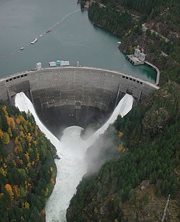
The W. A. C. Bennett Dam is a large hydroelectric dam on the Peace River in northern British Columbia, Canada. At 183 metres (600 ft) high, it is one of the world's highest earth fill dams. Construction of the dam began in 1961 and culminated in 1968. At the dam, the Finlay, the Parsnip and the Peace Rivers feed into Williston Lake, also referred to as Williston Reservoir. It is the third largest artificial lake in North America as well as the largest body of fresh water in British Columbia. Williston Lake runs 250 kilometres north-south and 150 kilometres east-west.

The BC Hydro and Power Authority is a Canadian electric utility in the province of British Columbia, generally known simply as BC Hydro. It is the main electricity distributor, serving 1.8 million customers in most areas, with the exception of the City of New Westminster, where the city runs its own electrical department and the Kootenay region, where FortisBC, a subsidiary of Fortis Inc. directly provides electric service to 213,000 customers and supplies municipally owned utilities in the same area. As a provincial Crown corporation, BC Hydro reports to the BC Ministry of Energy and Mines, and is regulated by the British Columbia Utilities Commission (BCUC). Its mandate is to generate, purchase, distribute and sell electricity.

Grand Coulee Dam is a concrete gravity dam on the Columbia River in the U.S. state of Washington, built to produce hydroelectric power and provide irrigation water. Constructed between 1933 and 1942, Grand Coulee originally had only two powerhouses. The third powerhouse, completed in 1974 to increase energy production, makes Grand Coulee the largest power station in the United States by nameplate-capacity at 6,809 MW.
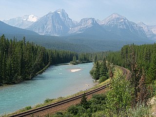
The Bow River is a river in the Canadian province of Alberta. It begins in the Rocky Mountains and winds through the Alberta foothills onto the prairies, where it meets the Oldman River, the two then forming the South Saskatchewan River. These waters ultimately flow through the Nelson River into Hudson Bay. The Bow River runs through the city of Calgary, taking in the Elbow River at the historic site of Fort Calgary near downtown. The Bow River pathway, developed along the river's banks, is considered a part of Calgary's self-image.

The Columbia River drainage basin is the drainage basin of the Columbia River in the Pacific Northwest region of North America. It covers 668,000 km2 or 258,000 sq mi. In common usage, the term often refers to a smaller area, generally the portion of the drainage basin that lies within eastern Washington.

The Kootenay is a major river in the Northwest Plateau, within the borders of southeastern British Columbia, Canada, and northern Montana and Idaho in the United States. It is one of the uppermost major tributaries of the Columbia River, the largest North American river that empties into the Pacific Ocean. The Kootenay River runs 781 kilometres (485 mi) from its headwaters in the Kootenay Ranges of the Canadian Rockies, flowing from British Columbia's East Kootenay region into northwestern Montana, then west into the northernmost Idaho Panhandle and returning to British Columbia in the West Kootenay region, where it joins the Columbia at Castlegar.

Hugh Keenleyside Dam (originally known as the High Arrow Dam is a flood control dam spanning the Columbia River, 12 km upstream of the city of Castlegar, British Columbia, Canada.

The Columbia Basin Project in Central Washington, United States, is the irrigation network that the Grand Coulee Dam makes possible. It is the largest water reclamation project in the United States, supplying irrigation water to over 670,000 acres (2,700 km2) of the 1,100,000 acres (4,500 km2) large project area, all of which was originally intended to be supplied and is still classified as irrigable and open for the possible enlargement of the system. Water pumped from the Columbia River is carried over 331 miles (533 km) of main canals, stored in a number of reservoirs, then fed into 1,339 miles (2,155 km) of lateral irrigation canals, and out into 3,500 miles (5,600 km) of drains and wasteways. The Grand Coulee Dam, powerplant, and various other parts of the CBP are operated by the Bureau of Reclamation. There are three irrigation districts in the project area, which operate additional local facilities.
The Columbia River Treaty is a 1961 agreement between Canada and the United States on the development and operation of dams in the upper Columbia River basin for power and flood control benefits in both countries. Four dams were constructed under this treaty: three in British Columbia, Canada and one in Montana in the United States.

Kitimat is a district municipality in the North Coast region of British Columbia, Canada. It is a member municipality of the Regional District of Kitimat-Stikine regional government. The Kitimat Valley is part of the most populous urban district in northwest British Columbia, which includes Terrace to the north along the Skeena River Valley. The city was planned and built by the Aluminum Company of Canada (Alcan) during the 1950s.
Ross Dam is a 540-foot (160 m)-high, 1,300-foot (400 m)-long concrete thin arch dam across the Skagit River, forming Ross Lake. The dam is in Washington State, while Ross Lake extends 23 miles (37 km) north to British Columbia, Canada. Both dam and reservoir are located in Ross Lake National Recreation Area, is bordered on both sides by Stephen Mather Wilderness and combined with Lake Chelan National Recreation Area they make up North Cascades National Park Complex.

Columbia Power Corporation is a Crown Corporation, owned by the province of British Columbia, Canada. Its mandate is to undertake hydro-electricity projects in the Columbia River region of British Columbia. In so doing, it is required to work with its sister crown corporation the Columbia Basin Trust.
The Kenney Dam is a rock-fill embankment dam on the Nechako River in northwestern British Columbia, built in the early 1950s. The impoundment of water behind the dam forms the Nechako Reservoir, which is also commonly known as the Ootsa Lake Reservoir. The dam was constructed to power an aluminum smelter in Kitimat, British Columbia by Alcan, although in the late 1980s the company increased their economic activity by selling excess electricity across North America. The development of the dam caused various environmental problems along with the displacement of the Cheslatta T'En First Nation, whose traditional land was flooded.
The Nechako Reservoir, sometimes called the Ootsa Lake Reservoir, is a hydroelectric reservoir in British Columbia, Canada that was formed by the Kenney Dam making a diversion of the Nechako River through a 16-km intake tunnel in the Kitimat Ranges of the Coast Mountains to the 890 MW Kemano Generating Station at sea level at Kemano to service the then-new Alcan aluminum smelter at Kitimat. When it was constructed on the Nechako River in 1952, it resulted in the relocation of over 75 families. It was one of the biggest reservoirs built in Canada until the completion of the Columbia Treaty Dams and the W.A.C. Bennett Dam that created Lake Williston. The water level may swing 10 feet between 2790 and 2800 feet.
The Nile Basin Initiative (NBI) is a partnership among the Nile riparian states that “seeks to develop the river in a cooperative manner, share substantial socioeconomic benefits, and promote regional peace and security”. The NBI began with a dialogue among the riparian states that resulted in a shared vision objective “to achieve sustainable socioeconomic development through the equitable utilization of, and benefit from, the common Nile Basin water resources." It was formally launched in February 1999 by the water ministers of nine countries that share the river: Egypt, Sudan, Ethiopia, Uganda, Kenya, Tanzania, Burundi, Rwanda, the Democratic Republic of Congo (DRC), as well as Eritrea as an observer. From its beginning the Nile Basin Initiative has been supported by the World Bank and by other external partners. The World Bank has a mandate to support the work of the NBI, as lead development partner and as administrator of the multi-donor Nile Basin Trust Fund. One of the partners is the "Nile Basin Discourse", which describes itself as "a civil society network of organisations seeking to achieve positive influence over the development of projects and programmes under the Nile Basin Initiative".

The Site C Dam is an early-stage project of BC Hydro for a large-scale earth fill hydroelectric dam on the Peace River near Fort St. John in northeastern British Columbia, Canada. The site is downstream from the existing W.A.C. Bennett and Peace Canyon dams. Designs call for an estimated peak capacity of approximately 1,100 MW, average output of 900 MW, and an annual output of 5,100 GWh of electricity. When completed, Site C will be the first large dam built in BC since 1984 and BC's fourth largest producer of electricity. However, the project has drawn considerable opposition from several quarters due to its planned flooding of agricultural land, lack of support from some First Nations groups and local landowners, high cost of the project vs. projected revenues, uncertainty of future demand and future electricity prices, possible alternatives, and cost to the environment.

The Cheslatta Carrier NationCheslatta T'En, of the Dakelh or Carrier people (Ta-cullies, meaning "people who go upon water", whose traditional lands where originally where the Kitimat Kemano Project I was built, form a large portion of the Central Interior of present-day British Columbia, Canada, is a First Nation of the Nechako River area at the headwaters of the Fraser River.
Moran Dam, also called High Moran Dam or Moran Canyon Dam, was a 1950s proposal to dam the Fraser River in the Canadian province of British Columbia (BC). The structure was planned in the wake of devastating floods in a time of rapidly growing power demand, and if built, would have powered the largest hydroelectric facility in North America. After a protracted environmental battle, Moran Dam was defeated in 1972, mainly over concerns of its adverse impact on salmon populations in the Fraser River basin. The shelving of the project also influenced cancellation of other hydro developments along the river, and today the Fraser remains one of the most productive salmon fisheries on the continent.
This page describes energy and electricity production, consumption and import in Laos.