
Small hydro is the development of hydroelectric power on a scale suitable for local community and industry, or to contribute to distributed generation in a regional electricity grid. Exact definitions vary, but a "small hydro" project is less than 50 megawatts (MW), and can be further subdivide by scale into "mini" (<1MW), "micro" (<100 kW), "pico" (<10 kW). In contrast many hydroelectric projects are of enormous size, such as the generating plant at the Three Gorges Dam at 22,500 megawatts or the vast multiple projects of the Tennessee Valley Authority.

The W. A. C. Bennett Dam is a large hydroelectric dam on the Peace River in northern British Columbia, Canada. At 186 metres (610 ft) high, it is one of the world's highest earth fill dams. Construction of the dam began in 1961 and culminated in 1968. At the dam, the Finlay, the Parsnip and the Peace rivers feed into Williston Lake, also referred to as Williston Reservoir. It is the third largest artificial lake in North America as well as the largest body of fresh water in British Columbia. Williston Lake runs 250 kilometres north–south and 150 kilometres east–west.
The British Columbia Hydro and Power Authority, operating as BC Hydro, is a Canadian electric utility in the province of British Columbia. It is the main electricity distributor, serving more than 4 million customers in most areas, with the exception of the City of New Westminster, where the city runs its own electrical department and portions of the West Kootenay, Okanagan, the Boundary Country and Similkameen regions, where FortisBC, a subsidiary of Fortis Inc. directly provides electric service to 213,000 customers and supplies municipally owned utilities in the same area. As a provincial Crown corporation, BC Hydro reports to the BC Ministry of Energy, Mines and Low Carbon Innovation, and is regulated by the British Columbia Utilities Commission (BCUC). Its mandate is to generate, purchase, distribute and sell electricity.

The Elk River is a 220-kilometre (140 mi) long river, in the southeastern Kootenay district of the Canadian province of British Columbia. Its drainage basin is 4,450 square kilometres (1,720 sq mi) in area. Its mean discharge is approximately 60 cubic metres per second (2,100 cu ft/s), with a maximum recorded discharge of 818 cubic metres per second (28,900 cu ft/s). It is a tributary of the Kootenay River, and falls within the basin of the Columbia River.

The Kootenay River or Kootenai River is a major river of the Northwest Plateau in southeastern British Columbia, Canada, and northern Montana and Idaho in the United States. It is one of the uppermost major tributaries of the Columbia River, the largest North American river that empties into the Pacific Ocean. The Kootenay River runs 781 kilometres (485 mi) from its headwaters in the Kootenay Ranges of the Canadian Rockies, flowing from British Columbia's East Kootenay region into northwestern Montana, then west into the northernmost Idaho Panhandle and returning to British Columbia in the West Kootenay region, where it joins the Columbia at Castlegar.
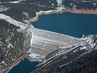
Mica Dam is a hydroelectric embankment dam spanning the Columbia River 135 kilometres north of Revelstoke, British Columbia, Canada. It was built as one of three Canadian projects under the terms of the 1964 Columbia River Treaty and is operated by BC Hydro. Completed in 1973, the Mica powerhouse had an original generating capacity of 1,805 megawatts (MW). Mica Dam, named after the nearby settlement of Mica Creek and its associated stream, in turn named after the abundance of mica minerals in the area, is one of the largest earthfill dams in the world. The reservoir created by the dam is Kinbasket Lake. Water from the dam flows south directly into Revelstoke Lake, the reservoir for the Revelstoke Dam. Mica Dam is the tallest dam in Canada and second tallest in North America after the Chicoasén Dam in Mexico and it is the farthest upstream dam on the Columbia River. The dam's underground powerhouse was the second largest in the world at the time of its construction, and was the first 500 kV installation of sulphur hexafluoride (SF6) insulated switchgear in the world.

Hugh Keenleyside Dam is a flood control dam spanning the Columbia River, 12 km upstream of the city of Castlegar, British Columbia, Canada.

Kootenay Lake is a lake located in British Columbia, Canada. It is part of the Kootenay River. The lake has been raised by the Corra Linn Dam and has a dike system at the southern end, which, along with industry in the 1950s–70s, has changed the ecosystem in and around the water. The Kootenay Lake ferry is a year-round toll-free ferry that crosses between Kootenay Bay and Balfour. The lake is a popular summer tourist destination.

The Arrow Lakes in British Columbia, Canada, divided into Upper Arrow Lake and Lower Arrow Lake, are widenings of the Columbia River. The lakes are situated between the Selkirk Mountains to the east and the Monashee Mountains to the west. Beachland is fairly rare, and is interspersed with rocky headlands and steep cliffs. Mountain sides are heavily forested, and rise sharply to elevations around 2,600 metres.
The Columbia River Treaty is a 1961 agreement between Canada and the United States on the development and operation of dams in the upper Columbia River basin for power and flood control benefits in both countries. Four dams were constructed under this treaty: three in the Canadian province of British Columbia and one in the U.S. state of Montana.

Lajoie Dam is the uppermost of the storage dams of BC Hydro's Bridge River Power Project, which is located in the southwestern Interior of British Columbia. It is located just west of the small semi-ghost town of Gold Bridge. An earthfill structure, it is 87 m (287 ft) and impounds c. 570,000 acre-feet (700,000,000 m3) of water in Downton Lake Reservoir. The Lajoie Powerhouse generates 22 MW with an average generating capacity of 170 GWh/year. A few miles downstream is Carpenter Lake, which is formed by Terzaghi Dam, the largest of the Bridge River Power Project's structures.
Run-of-river hydroelectricity (ROR) or run-of-the-river hydroelectricity is a type of hydroelectric generation plant whereby little or no water storage is provided. Run-of-the-river power plants may have no water storage at all or a limited amount of storage, in which case the storage reservoir is referred to as pondage. A plant without pondage is subject to seasonal river flows, so the plant will operate as an intermittent energy source. Conventional hydro uses reservoirs, which regulate water for flood control, dispatchable electrical power, and the provision of fresh water for agriculture.
FortisBC is a Canadian owned, British Columbia based regulated utility providing natural gas, and electricity. FortisBC has approximately 2,600 employees serving more than 1.2 million customers in 135 B.C. communities and 58 First Nations communities across 150 Traditional Territories.
The Duncan River is in the West Kootenay region of southeastern British Columbia. Entering the North Arm of Kootenay Lake, the river is a major tributary of the Kootenay River, which in turn flows into the Columbia River. The Selkirk Mountains lie to the west and the Purcell Mountains to the east.
According to the International Hydropower Association, Canada is the fourth largest producer of hydroelectricity in the world in 2021 after the United States, Brazil, and China. In 2019, Canada produced 632.2 TWh of electricity with 60% of energy coming from Hydroelectric and Tidal Energy Sources).

Corra Linn Dam is a concrete hydroelectric dam on the Kootenay River between the cities of Castlegar and Nelson, in the West Kootenay region of southern British Columbia.

The Kootenay Canal is a hydroelectric power station, located 19 km downstream of Nelson, British Columbia, Canada. Where the Kootenay River flows out of the reservoir formed by the Corra Linn Dam on Kootenay Lake., a canal diverts water to BC Hydro's Kootenay Canal Generating Station. Its construction was a result of the Duncan Dam and Libby Dam providing year round flows into Kootenay Lake. The powerhouse was completed in 1976.
Azhutha Dam is a small diversion dam built on the Azhutha River which is a tributary of the Pamba River, at Azhutha in Peerumed Grama Panchayat of Idukki District, Kerala, India. It is a small concrete gravity dam that is only 72 metres (236 ft) long and 14 metres (46 ft) high. It acts mainly as a diversion dam to supply water to the Idukki Dam. The Azhutha Dam was constructed as an augmentation dam for the Idukki Hydro Electric Project. Construction of the project started in 1987 and was expected to be commissioned in 1991, but the project overrun and was only partially commissioned in June 1998. The year of completion was 2007. The release of the water from the dam is to Azhutha river and it flows through Ranni and Ayroor taluks.
Veluthodu dam is a part of Kakkad Hydro Electric Project and is located in Seethathode panchayath of Ranni Taluk in Pathanamthitta District of Kerala, India. Its a Concrete-Gravity dam built across the Veluthodu river, a tributary of Kakkad River which is again a tributary of Pamba River The dam is built primarily for electricity. This diversion dam diverts water to the water conductor system from Moozhiyar reservoir to Kakkad Power Station. This power station utilises the tail race water from Sabarigiri power station and flow received from moozhiyar and velluthode rivers. After power generation, water from Kakkad power station is released to the Kakkad River. Taluks through which release flow are Ranni, Konni, Kozhencherry, Thiruvalla, Chengannur, Kuttanadu, Mavelikara and Karthikappally It is operated by Kerala State Electricity Board.

