
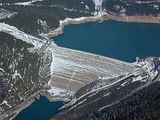
The W. A. C. Bennett Dam is a large hydroelectric dam on the Peace River in northern British Columbia, Canada. At 186 metres (610 ft) high, it is one of the world's highest earth fill dams. Construction of the dam began in 1961 and culminated in 1968. At the dam, the Finlay, the Parsnip and the Peace rivers feed into Williston Lake, also referred to as Williston Reservoir. It is the third largest artificial lake in North America as well as the largest body of fresh water in British Columbia. Williston Lake runs 250 kilometres north–south and 150 kilometres east–west.
The British Columbia Hydro and Power Authority, operating as BC Hydro, is a Canadian electric utility in the province of British Columbia. It is the main electricity distributor, serving more than 4 million customers in most areas, with the exception of the City of New Westminster, where the city runs its own electrical department and portions of the West Kootenay, Okanagan, the Boundary Country and Similkameen regions, where FortisBC, a subsidiary of Fortis Inc. directly provides electric service to 213,000 customers and supplies municipally owned utilities in the same area. As a provincial Crown corporation, BC Hydro reports to the BC Ministry of Energy, Mines and Low Carbon Innovation, and is regulated by the British Columbia Utilities Commission (BCUC). Its mandate is to generate, purchase, distribute and sell electricity.

The Kootenay River or Kootenai River is a major river of the Northwest Plateau in southeastern British Columbia, Canada, and northern Montana and Idaho in the United States. It is one of the uppermost major tributaries of the Columbia River, the largest North American river that empties into the Pacific Ocean. The Kootenay River runs 781 kilometres (485 mi) from its headwaters in the Kootenay Ranges of the Canadian Rockies, flowing from British Columbia's East Kootenay region into northwestern Montana, then west into the northernmost Idaho Panhandle and returning to British Columbia in the West Kootenay region, where it joins the Columbia at Castlegar.
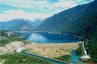
Mica Dam is a hydroelectric embankment dam spanning the Columbia River 135 kilometres north of Revelstoke, British Columbia, Canada. It was built as one of three Canadian projects under the terms of the 1964 Columbia River Treaty and is operated by BC Hydro. Completed in 1973, the Mica powerhouse had an original generating capacity of 1,805 megawatts (MW). Mica Dam, named after the nearby settlement of Mica Creek and its associated stream, in turn named after the abundance of mica minerals in the area, is one of the largest earthfill dams in the world. The reservoir created by the dam is Kinbasket Lake. Water from the dam flows south directly into Revelstoke Lake, the reservoir for the Revelstoke Dam. Mica Dam is the tallest dam in Canada and second tallest in North America after the Chicoasén Dam in Mexico and it is the farthest upstream dam on the Columbia River. The dam's underground powerhouse was the second largest in the world at the time of its construction, and was the first 500 kV installation of sulphur hexafluoride (SF6) insulated switchgear in the world.

Hugh Keenleyside Dam is a flood control dam spanning the Columbia River, 12 km upstream of the city of Castlegar, British Columbia, Canada.

The Peace River is a 1,923-kilometre-long (1,195 mi) river in Canada that originates in the Rocky Mountains of northern British Columbia and flows to the northeast through northern Alberta. The Peace River joins the Athabasca River in the Peace-Athabasca Delta to form the Slave River, a tributary of the Mackenzie River. The Finlay River, the main headwater of the Peace River, is regarded as the ultimate source of the Mackenzie River. The combined Finlay–Peace–Slave–Mackenzie river system is the 13th longest river system in the world.

Kootenay Lake is a lake located in British Columbia, Canada. It is part of the Kootenay River. The lake has been raised by the Corra Linn Dam and has a dike system at the southern end, which, along with industry in the 1950s–70s, has changed the ecosystem in and around the water. The Kootenay Lake ferry is a year-round toll-free ferry that crosses between Kootenay Bay and Balfour. The lake is a popular summer tourist destination.
The Columbia River Treaty is a 1961 agreement between Canada and the United States on the development and operation of dams in the upper Columbia River basin for power and flood control benefits in both countries. Four dams were constructed under this treaty: three in the Canadian province of British Columbia and one in the U.S. state of Montana.
FortisBC is a Canadian owned, British Columbia based regulated utility providing natural gas, and electricity. FortisBC has approximately 2,600 employees serving more than 1.2 million customers in 135 B.C. communities and 58 First Nations communities across 150 Traditional Territories.

Columbia Lake is the primary lake at the headwaters of the Columbia River, in British Columbia, Canada. It is fed by several small tributaries. The village of Canal Flats is located at the south end of the lake.
The Nechako Reservoir, sometimes called the Ootsa Lake Reservoir, is a hydroelectric reservoir in British Columbia, Canada that was formed by the Kenney Dam making a diversion of the Nechako River through a 16-km intake tunnel in the Kitimat Ranges of the Coast Mountains to the 890 MW Kemano Generating Station at sea level at Kemano to service the then-new Alcan aluminum smelter at Kitimat. When it was constructed on the Nechako River in 1952, it resulted in the relocation of over 75 families. It was one of the biggest reservoirs built in Canada until the completion of the Columbia Treaty Dams and the W.A.C. Bennett Dam that created Lake Williston. The water level may swing 10 feet between 2790 and 2800 feet.
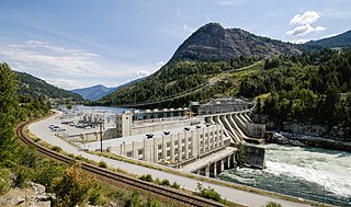
Brilliant Dam is a hydroelectric dam on the Kootenay River near Castlegar, British Columbia, Canada. It was built during the Second World War, mostly by Doukhobour men exempt from military service, and its 129 MW twin turbines first came into operation in June, 1944. The Columbia Power Corporation purchased the dam from Teck Cominco in 1996.
According to the International Hydropower Association, Canada is the fourth largest producer of hydroelectricity in the world in 2021 after the United States, Brazil, and China. In 2019, Canada produced 632.2 TWh of electricity with 60% of energy coming from Hydroelectric and Tidal Energy Sources).
Duncan Dam is a dam spanning the Duncan River in the Canadian province of British Columbia.

The Baillie-Grohman Canal was a shipping canal between the headwaters of the Columbia River and the upper Kootenay River in the East Kootenay region of British Columbia at a place now known as Canal Flats, BC. The construction of the canal was required by the provincial government of British Columbia as a condition of the canal's promoter receiving substantial land concessions from the provincial government of British Columbia in the area of Creston, BC. The promoter, William Adolf Baillie-Grohman (1851–1921), was a wealthy adventurer, hunter author, and business promoter. He declared the canal to be complete in 1889. The canal was an expensive failure, being used only three times during its entire existence. In 1902, on the last use by a vessel, the sternwheeler North Star, the sternwheeler's captain, Frank P. Armstrong deliberately blew out the canal's lower lock gates with dynamite to allow the transit of his vessel.

Bonnington Falls were waterfalls submerged by dams on the Kootenay River between the cities of Castlegar and Nelson, in the West Kootenay region of southern British Columbia. The upper falls was named after the Falls of Clyde upper falls of Bonnington Linn.

The Kootenay Canal is a hydroelectric power station, located 19 km downstream of Nelson, British Columbia, Canada. Where the Kootenay River flows out of the reservoir formed by the Corra Linn Dam on Kootenay Lake., a canal diverts water to BC Hydro's Kootenay Canal Generating Station. Its construction was a result of the Duncan Dam and Libby Dam providing year round flows into Kootenay Lake. The powerhouse was completed in 1976.
Denis-Perron dam is a rockfill embankment dam spanning the Sainte-Marguerite River, a tributary of the lower Saint Lawrence River, in eastern Quebec, Canada. Standing 171 metres (561 ft) high and 378 metres (1,240 ft) long, the dam is the primary component of Hydro-Québec's Sainte-Marguerite 3 hydroelectric project. The dam is the second highest in Quebec and the hydraulic head afforded to its power plant is also the largest in the province.

The Vilyuy Dam is a large dam and hydroelectric power station on the Vilyuy River in Chernyshevsky, Mirninsky District, Sakha Republic (Yakutia), Russia. The dam was built between 1964 and 1967 to provide power for diamond mines in the area. It is located in the southern part of the Vilyuy Plateau and was one of the first of such major structures in the world to be built on permafrost. Vilyuy is reported to have the coldest operating conditions of any hydroelectric plant in the world.

