This is a list of hydroelectric power stations in Guatemala : [1] [2] [3] The list is incomplete. The Guatemalan Electricity regulating Authority CNEE also has a listing on their website.
*) Building costs in millions of US$
This is a list of hydroelectric power stations in Guatemala : [1] [2] [3] The list is incomplete. The Guatemalan Electricity regulating Authority CNEE also has a listing on their website.

Central America is a subregion of North America. Its political boundaries are defined as bordering Mexico to the north, Colombia to the south, the Caribbean Sea to the east, and the Pacific Ocean to the west. Central America is usually defined as consisting of seven countries: Belize, Costa Rica, El Salvador, Guatemala, Honduras, Nicaragua, and Panama. Within Central America is the Mesoamerican biodiversity hotspot, which extends from northern Guatemala to central Panama. Due to the presence of several active geologic faults and the Central America Volcanic Arc, there is a high amount of seismic activity in the region, such as volcanic eruptions and earthquakes, which has resulted in death, injury, and property damage.
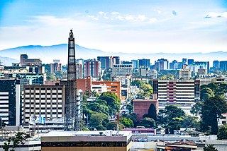
Guatemala City, known nationally also as Guate, is the capital and largest city of Guatemala. It is also a municipality capital of the Guatemala Department and the most populous urban area in Central America. The city is located in the south-central part of the country, nestled in a mountain valley called Valle de la Ermita.

The economy of Guatemala is a considered a developing economy, highly dependent on agriculture, particularly on traditional crops such as coffee, sugar, and bananas. Guatemala's GDP per capita is roughly one-third of Brazil's. The Guatemalan economy is the largest in Central America. It grew 3.3 percent on average from 2015 to 2018. However, Guatemala remains one of the poorest countries in Latin America and the Caribbean, having highly unequal incomes and chronically malnourished children. The country is beset by political insecurity, and lacks skilled workers and infrastructure. It depends on remittances for nearly one-tenth of the GDP.
Guatemalans are people connected to the country of Guatemala. This connection may be residential, legal, historical or cultural. For most Guatemalans, several of these connections exist.
The Guatemala national football team represents Guatemala in men's international football and is controlled by the Federación Nacional de Fútbol de Guatemala. Founded in 1919, it has been affiliated to FIFA since 1946, as a member of CONCACAF.
The Nicaragua national football team represents Nicaragua in men's international football and is controlled by the Nicaraguan Football Federation. Nicaragua achieved their first qualification into a major international competition in 2009, as they qualified for the 2009 Gold Cup as the last entrant from Central America, after a 2–0 victory against Guatemala in the fifth place match in the 2009 Nations Cup. However, the team has never qualified for the FIFA World Cup.
Concepción is a municipality in the Sololá department of Guatemala. The outstanding characteristic of the municipality is that 100% of its inhabitants are native people.

Mundo Maya International Airport, formerly Flores International Airport as indicated by its 3-letter code, is an international airport located in the suburb of Santa Elena, in the city of Flores, Guatemala. It serves national and international air traffic for the areas of Flores, Santa Elena, and San Benito, as well as all the Maya sites of Tikal or Yaxhá and destinations such as Guatemala City and Belize.

Volcán Tajumulco is a large stratovolcano in the department of San Marcos in western Guatemala. It is the highest mountain in Central America at 4,203 metres (13,789 ft). It is part of the mountain range of the Sierra Madre de Chiapas, which begins in Mexico's southernmost state of Chiapas.
Which Wich Superior Sandwiches is an American fast casual restaurant chain specializing in sandwiches and salads. It has its headquarters in Downtown Dallas, Texas. As of 2022, it has 168 locations open in 27 U.S. states as well as the District of Columbia, along with international locations in Oman, Qatar, Saudi Arabia and the United Kingdom.

The volcano Tacaná is the second highest peak in Central America at 4,060 metres (13,320 ft), located in the Sierra Madre de Chiapas of northern Guatemala and southern Mexico. It is also known in Mexico as Volcán Tacina.
Guatemalan Americans are Americans of full or partial Guatemalan descent. The Guatemalan American population at the 2010 Census was 1,044,209. Guatemalans are the sixth largest Hispanic group in the United States and the second largest Central American population after Salvadorans. Half of the Guatemalan population is situated in two parts of the country, the Northeast and Southern California.
The Colombia women's national football team represents Colombia in international women's football competitions and is controlled by the Colombian Football Federation. They are a member of the CONMEBOL. The team is currently ranked 28th in the FIFA Ranking and has qualified for three FIFA Women's World Cups, in Germany 2011, Canada 2015 and Australia–New Zealand 2023.
The Venezuela women's national football team represents Venezuela in international women's football.
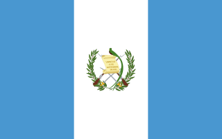
Guatemala, officially the Republic of Guatemala, is a country in Central America. It is bordered to the north and west by Mexico, to the northeast by Belize, to the east by Honduras, and to the southeast by El Salvador. It is hydrologically bordered to the south by the Pacific Ocean and to the northeast by the Gulf of Honduras.
Guatemala participated in the 2010 Summer Youth Olympics in Singapore.

Guatemala–India relations refers to the bilateral ties between India and Guatemala. The countries established diplomatic relations with each other in the 1970s, and have decided to open resident missions in the other country.