Westport, Oregon | |
|---|---|
 Volunteer Fire Department in Westport | |
 Westport Location within the state of Oregon  Westport Westport (the United States) | |
| Coordinates: 46°07′45″N123°22′31″W / 46.12917°N 123.37528°W | |
| Country | United States |
| State | Oregon |
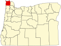
| County | Clatsop |
| Area | |
• Total | 0.66 sq mi (1.72 km2) |
| • Land | 0.66 sq mi (1.72 km2) |
| • Water | 0.00 sq mi (0.00 km2) |
| Elevation | 16 ft (5 m) |
| Population | |
• Total | 319 |
| • Density | 481.15/sq mi (185.90/km2) |
| Time zone | UTC-8 (Pacific (PST)) |
| • Summer (DST) | UTC-7 (PDT) |
| ZIP code | 97016 |
| Area codes | 503 and 971 |
| FIPS code | 41-80400 |
| GNIS feature ID | 2611784 [2] |
Westport is an unincorporated community and census-designated place on the Columbia River in Clatsop County, Oregon, United States. As of the 2010 census, it had a population of 321. [4]
Contents
Westport is connected to Cathlamet, Washington, across the river via the Wahkiakum County ferry to Puget Island. U.S. Route 30 passes through the community, connecting it to Astoria to the west and Clatskanie to the east. [5]
Westport is named after "Captain" John West, a millwright and lumberman who settled in the area in the early 1850s. [6] West was a native of Scotland, [6] emigrated to Canada as a young man where he worked in a sawmill on the St. Lawrence River and then came to Oregon via California during the gold rush of 1849. [7] West ran a sawmill and a salmon cannery in the community. [6] The Westport post office was established in 1863 [6] with West as its first postmaster.[ citation needed ]