River Point, Oregon | |
|---|---|
 River Point  River Point | |
| Coordinates: 46°08′36″N123°48′15″W / 46.14333°N 123.80417°W | |
| Country | United States |
| State | Oregon |
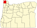
| County | Clatsop |
| Area | |
• Total | 0.60 sq mi (1.56 km2) |
| • Land | 0.52 sq mi (1.35 km2) |
| • Water | 0.08 sq mi (0.21 km2) |
| Elevation | 49 ft (15 m) |
| Population | |
• Total | 397 |
| • Density | 762.00/sq mi (294.45/km2) |
| Time zone | UTC-8 (Pacific (PST)) |
| • Summer (DST) | UTC-7 (PDT) |
| ZIP Code | 97103 (Astoria) |
| Area codes | 503/971 |
| FIPS code | 41-62292 |
| GNIS feature ID | 2812873 [2] |
River Point is an unincorporated community and census-designated place (CDP) in Clatsop County, Oregon, United States. It was first listed as a CDP prior to the 2020 census. [2]
Contents
The CDP is in northwestern Clatsop County, 4 miles (6 km) south of Astoria along Oregon Route 202, the Nehalem Highway. It sits on the land between two rivers, the Youngs River to the west and the Wallooskee River to the north, extending to their confluence. The Youngs River is a tidal waterway leading to Youngs Bay at Astoria and thence the Columbia River.