Navy Heights, Oregon | |
|---|---|
 Navy Heights  Navy Heights | |
| Coordinates: 46°11′23″N123°46′46″W / 46.18972°N 123.77944°W | |
| Country | United States |
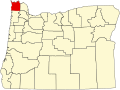
| State | Oregon |
| County | Clatsop |
| Elevation | 325 ft (99 m) |
| Time zone | UTC-8 (Pacific (PST)) |
| • Summer (DST) | UTC-7 (PDT) |
| ZIP code | 97103 |
| Area codes | 503 and 971 |
| GNIS feature ID | 1136563 [1] |
Navy Heights is an unincorporated community in Clatsop County, Oregon, United States. [2] It began as a housing project in nearby Astoria. [3]