Wauna, Oregon | |
|---|---|
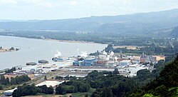 Paper mill from Bradley State Scenic Viewpoint | |
 Wauna Location within the state of Oregon  Wauna Wauna (the United States) | |
| Coordinates: 46°09′25″N123°24′22″W / 46.15694°N 123.40611°W [1] | |
| Country | United States |
| State | Oregon |
| County | Clatsop |
| Elevation | 20 ft (6 m) |
| Time zone | UTC-8 (Pacific (PST)) |
| • Summer (DST) | UTC-7 (PDT) |
| ZIP code | 97016 |
| Area codes | 503 and 971 |
| GNIS feature ID | 1128740 [1] |
Wauna is an unincorporated community on the Columbia River in Clatsop County, Oregon, United States. According to Oregon Geographic Names, it names a Native American mythological being associated with the Columbia River. There was a post office in Wauna from January 21, 1911, to circa 1980. Wauna is best known as the home of a Georgia-Pacific paper mill.